
Grantee Research Project Results
Final Report: A Probabilistic Framework for Projections of Watershed Services in US Headwaters under Climate Change Scenarios
EPA Grant Number: R834196Title: A Probabilistic Framework for Projections of Watershed Services in US Headwaters under Climate Change Scenarios
Investigators: Wagener, Thorsten
Institution: Pennsylvania State University
EPA Project Officer: Packard, Benjamin H
Project Period: August 1, 2009 through July 31, 2012 (Extended to July 31, 2013)
Project Amount: $239,782
RFA: Consequences of Global Change for Water Quality (2008) RFA Text | Recipients Lists
Research Category: Aquatic Ecosystems , Ecological Indicators/Assessment/Restoration , Watersheds , Water , Climate Change
Objective:
Watersheds collect, store and release incoming precipitation and thus provide important freshwater related ecosystem services for aquatic ecosystems and for human uses. US headwaters are particularly important source regions and highly sensitive to climate change impacts. Headwater streams are the most abundant portion of the river network but conversely the least monitored. As such, we have a limited understanding of headwater stream behavior and how it is influenced by catchment properties such as topography and vegetation. Observational networks are strongly biased towards larger rivers, despite the increasingly recognized importance of headwaters in controlling ecological and water quality functions throughout river basins. Our hydrologic knowledge of and modeling capabilities in these headwaters are very low, which severely limits our ability to assess ecosystem services.
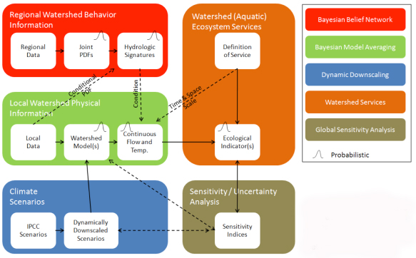
The objective of this project has been to provide probabilistic projections of indicators of watershed services for aquatic ecosystems and human uses in US headwaters under historical conditions and potential future climate change scenarios through (see Fig. 1):
- Characterizing changes to (freshwater flow and temperature dependent) indicators of watershed services under climate change scenarios in a probabilistic framework.
- Identifying main controls (and uncertainties) on these indicators.
- Estimation of resulting changes to watershed‐scale ecosystem services for selected headwater basins in different US regions.
Figure 1. Schematic representation of the project and its elements, as well as the connectivity between
elements.
Summary/Accomplishments (Outputs/Outcomes):
Here we discuss briefly our findings in the context of the four hypotheses posed by the project.
Hypothesis 1
Assimilating regional information on watershed response behavior into watershed models built from local physical characteristics will significantly reduce the uncertainty in watershed model predictions of critical hydrologic variables in ungauged headwater basins (including ET, soil moisture, snow and streamflow).
The vast majority of US headwater basins is ungauged with respect to important hydrologic variables such as streamflow. Most strategies for continuous predictions of hydrologic variables in ungauged basins focused on estimating the parameters of a hydrologic model through regionalization or by linking parameter estimates to local physical watershed characteristics such as soil types, i.e., a priori parameters. We proposed that valuable information can be gained by estimating the expected behavior of the watershed under study, rather than focusing on the hydrologic model (Wagener and Montanari, 2011). We tested this hypothesis in different locations (USA and South Africa), with different models (HBV, HyMod, DHSVM) and using both formal (Bayesian) and informal (set-theoretic) statistical frameworks to integrate different sources of information. We found that assimilating regionalized information on the expected hydrologic behavior of watersheds (in the form of hydrologic indices such as runoff ratio or baseflow index) significantly reduced uncertainty in ungauged basins (Singh, et al., 2013). This is not to say that strategies for estimating model parameters cannot still be improved (Singh, et al., 2014b). There can even be circumstances when local information on the model parameters is preferable. This is usually the case when streamflow observations used as a basis for the regional information are impacted by human abstractions (Kapangaziwiri, et al., 2012). We generally witnessed the emergence of approaches that combine both local (parameter) and regional (watershed response behavior) information to reduce uncertainty in a commentary and found a convergence of the community towards such strategies (Wagener and Montanari, 2011).
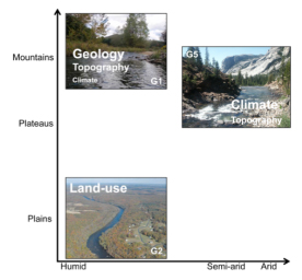
Figure 2. The major controls on parameter transfer
across the groups in this study. Each image represents
a watershed group. Climate is plotted on the x-axis
ranging from humid to arid. Topography is plotted on
the y-axis ranging from plains to mountains. The text
inside the image outlines the dominant controls on
successful parameter transfer for about 400 watersheds
distrubuted across the USA. (Singh et al., 2014b)
Hypothesis 2
Driving an ensemble of watershed models with downscaled climate change scenarios allows for an assessment of the uncertainty in the temporal propagation of climate signals through watershed flowpaths into different hydrologic response.
The propagation of downscaled climate projections through hydrological models has become a standard approach to estimating the potential regional impact of climate change on the water cycle. In a parallel project we have shown how the uncertainty in the downscaling process can be quantified and considered in an ensemble strategy (Ning et al., 2012a; 2012b). The approach uses a computationally inexpensive statistical downscaling strategy and can easily be tailored to any location of interest assuming that some historical meteorological observations are available. However, another issue came to light in this process.
Figure 3. Three-step procedure for predicting streamflow for future climate scenarios (Singh et al., 2013).
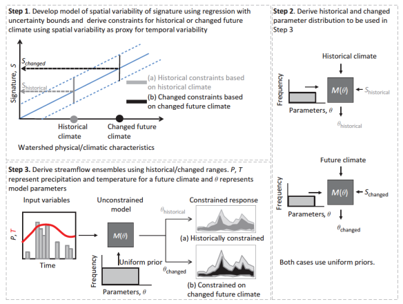
The common approach to derive climate change impact projections is by forcing a hydrologic model, calibrated on historical data or using a priori parameter estimates, with future scenarios of precipitation and temperature. It has been widely demonstrated that a priori parameters can be very unreliable and that calibration is generally needed for robust parameter estimates of watershed models. However, several recent studies suggest that the climatic regime of the calibration period is reflected in the resulting parameter estimates and model performance can be negatively impacted if the climate for which projections are made is significantly different from that during calibration. So how can we calibrate a hydrologic model for historically unobserved climatic conditions? To address this issue, we propose a new trading-space-for-time framework that utilizes the similarity between the predictions under change (PUC) and predictions in ungauged basins (PUB) problems (Singh et al., 2011; 2013). To demonstrate this new framework we first regionalize climate dependent streamflow characteristics (called signatures) using 394 US watersheds. We then assume that this spatial relationship between climate and streamflow characteristics is similar to the one we would observe between climate and streamflow over long time periods at a single location. This assumption is what we refer to as trading-space-for-time. Therefore, we change the limits for extrapolation to future climatic situations from the restricted locally observed historical variability to the variability observed across all watersheds used to derive the regression relationships. A typical watershed model is subsequently calibrated (conditioned) on the predicted signatures for any future climate scenario to account for the impact of climate on model parameters within a Bayesian framework. As a result, we can obtain ensemble predictions of continuous streamflow at both gauged and ungauged locations. We demonstrated the value new strategy for both the US (Singh et al., 2011) and for South Africa (Singh et al., 2013).
Hypothesis 3
Extracting indicators relevant for (specific) aquatic ecosystems and testing their controls (incl. model and climatic) through global sensitivity analysis will separate indicators most impacted by climate change from those more sensitive to other disturbances.
We have demonstrated and established the use of global sensitivity analysis to understand the dominant controls in environmental models over the last few years. We demonstrated the methodology for a wide range of model complexities ranging from empirical models of water temperature (Kelleher et al., 2012) all the way to highly complex and detailed models of watershed hydrology (Kelleher et al., 2014a;b). We demonstrated how geomorphological differences between river reaches control their transient storage behavior (Kelleher et al., 2013, Fig. 4), and introduced the concept of thermal elasticity to quantify the relative differences between streams to warm up under potential climate or land use change (Kelleher et al., 2012).
Figure 4. Stringer Creek is a generally gaining, montane headwater stream, which drains a subcatchment of the Tenderfoot Creek Experimental Forest (TCEF), Montana.
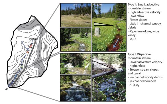
TCEF has a predominantly continental climate, with an average annual precipitation of 840 mm. Photographs and summaries of the general traits of the two stream types along Stringer Creek. Photos taken by R. Payn and C. Kelleher. (Kelleher et al., 2013)
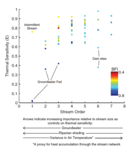
Figure 5. Stram order versus thermal sensitivity,
across 57 Pennsylvania streams. Colour highlights
baseflow contribution, in terms of BFI (baseflow index).
Sites where thermal sensitivity is influenced by a unique
site condition are noted on the figure. General controls
on thermal sensitivity and their influence relative to
stream size are conceptualized at the bottom of
the figure. (Kelleher et al., 2012).
In an extensive study of several sub-catchments of the Tenderfoot Creek Experimental Forest in Montana we demonstrate how the sensitivity analysis of complex and physically-based models can reveal relevant controls on hydrologic behavior, even in ungauged headwater basins (Kelleher et al., 2014a, Fig. 6&7). We use a distributed, physically-based watershed model, the Distributed Hydrology-Soil-Vegetation Model (DHSVM) combined with global, variance-based sensitivity analysis to investigate physical controls on a range of model-predicted hydrologic behavior (i.e. States) across time scales. We find that only a few vegetation and soil parameters control the variability in hydrologic partitioning across these sub- catchments. At an annual scale, lateral conductivity, the change in lateral conductivity with depth, vapor pressure deficit, and vegetation density control variability each of the predicted model states. At a weekly scale, streamflow and Evapo-transpiration are controlled by the density and leaf area of the Lodgepole pine forest during high flow. During the period of dry-down through the summer months, evapotranspiration and soil moisture are controlled by vapor pressure deficit for the shrub and grass understory. Streamflow during drier periods is controlled by the exponential decrease in lateral conductivity with depth, responsible for redistribution of soil water in the subsurface. Similarly, we estimated the varying controls with location across different US watersheds (Kelleher et al., 2014b).
Figure 6. Sensitivity analysis results in using DHSVM for TCEF show the different time-varying
controls on evapotranspiration as a function of the land cover of two sub-catchments. We identify
the switch from vegetation to soil control during the season. Colours refer to parameters, not to
sub-watersheds. Higher sensitivity indices mean more dominant controls. (Kelleher et al., 2014a).
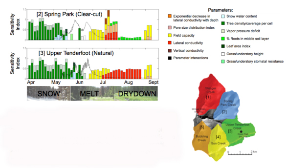
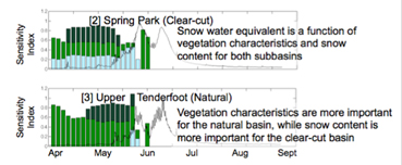
Figure 7. We can similarly evaluate the controls on evaluating
controls on snow water equivalent. A small number of parameters
control the majority of variance in hydrologic partitioning for a
complex watershed model. (Kelleher et al., 2014a).
We also found limitations in our ability to understand change implications or controls on change. In the study by Martin et al. (2012) we found that we could not detect signs of urbanization in a wide range of ecologically relevant streamflow indices. Our own work including a review of the literature suggest that urbanization levels below 15% are unlikely to be detectable empirically given other sources of variability between urbanized and rural watersheds. The presence of model structural error can also limit the usefulness of modeled frameworks as shown in the study by Kollat et al. (2012). We established a trade-off analysis that can be used to quantify he presence of model structural error though, while only making a few simple assumptions.
Hypothesis 4
Assessing climate change impacts on indicators in very different hydro-‐climatic regions will reveal differences in climate change impacts on aquatic ecosystems across the US. We have pursued extensive analysis of downscaled scenarios for hydrological applications. A main conclusion of this work is that the uncertainty of downscaled precipitation is often prohibitively high for effective decision-making. For example, precipitation projections for Pennsylvania often include both potential increases and potential decreases (Ning et al., 2012a,b; Singh et al., 2014a), while the sign of rainfall projections varies with the chosen GCM in dry regions (Singh et al., 2013). Large uncertainties in streamflow projections derived from downscaled climate projections of precipitation and temperature can render such simulations of limited value for decision making in the context of water resources management.
New approaches are being sought to provide decision makers with robust information in the face of large uncertainties. We developed an alternative approach that starts with the stakeholders definition of vulnerable ranges for relevant hydrologic indicators (Singh et al., 2014a, Fig. 8). Then, the modeled system is analyzed to assess under what conditions these thresholds are exceeded. The space of possible climates and land use combinations for a watershed is explored to isolate sub-spaces that lead to vulnerability, while considering model parameter uncertainty in the analysis. We implement this concept using classification and regression trees (CART) that separate the input space of climate and land use change into those combinations that lead to vulnerability and those that do not. We test our method in a Pennsylvania watershed for nine ecological and water resources related streamflow indicators for which an increase in temperature between 3°C to 6 °C and change in precipitation between -17% and 19% is projected. Our approach provides several insights such as it shows that even small decreases in precipitation (~5%) combined with temperature increases greater than 2.5ºC can push the mean annual runoff into a slightly vulnerable regime. Figure 9 shows the differences in information provided by the two strategies. Using this impact and stakeholder driven strategy, we explore the decision-relevant space more fully and provide information to the decision maker even if climate change projections are ambiguous.
Figure 8. (Left) The hydro-climatic framework showing the traditional forward propagation approach used to derive future changes in hydrologic variables of interest. (Right) The bottom-up approach used in this study, which starts by defining different (slightly vulnerable/vulnerable/non-vulnerable etc.) classes for a hydrologic indictor of interest and then identifying the regions in the input space that lead to each class. (Singh et al., 2014a)
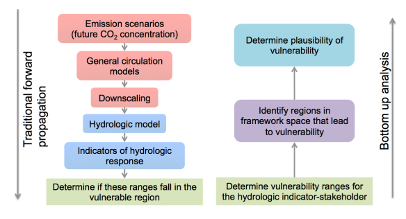
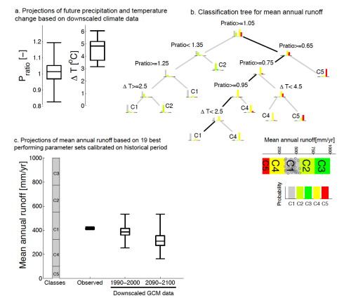
Figure 9. (a) Future ranges for precipitation and temperature change based on downscaled climate data. Precipitation change (Pratio) is expressed as the ratio of mean annual precipitation for end of century (2090-2100) projections to mean annual precipitation in the baseline (1990-2000) period. Temperature change (ΔT) is expressed as the difference between mean annual temperatures for end of century (2090-2100) projections to mean annual temperature in the baseline (1990-2000) period. (b) Classification tree for mean annual runoff (classes refer to similarity with historically observed variability, green is equal to historical). The black lines in (b) represent the future classes for mean annual streamflow derived from navigating the classification tree in (b) using precipitation and temperature changes in (a). (c) Projections of streamflow obtained by the traditional top-down approach by driving the hydrologic model directly with the future precipitation and temperature time series. 19 parameter sets fixed at their historically calibrated values are used. We compare the projections of mean annual streamflow derived from the bottom-up CART analysis in (b) to those derived directly from the top-down method using statistically downscaled GCM output (c). (Singh et al., 2014a)
Conclusions:
Here, we briefly summarize the main conclusions of our project. We expected that the successful execution of this project would significantly advance our ability to simulate the impact of climate change on US headwater ecosystem services, and therefore on the future of aquatic ecosystems and the sustainability of human water uses. We think that our results demonstrate that we have fulfilled this expectation. Though we also have adjusted our initial ideas where necessary to comply with our findings, e.g., in the case of the vulnerability-based strategy for climate change impact assessment. The four main conclusions of our project are:
- To maximize uncertainty reduction in ungauged basins, it is advantageous to simultaneously focus on both reducing the uncertainty in the hydrologic model (mainly the model parameters) and in the expected values of selected hydrologic signatures of the watershed under study. The merger of both sources of information leads to reduced predictive uncertainty.
- We introduced a novel trading-space-for-time approach to establish a consistent uncertainty framework for hydrologic ensemble prediction in gauged and ungauged watersheds, and under current and potential future climate conditions. This new approach allows for the assimilation of different types of information in a single framework to reduce prediction uncertainty.
- We demonstrate that we can compare the influences of soil and vegetation across headwater streams and basins, using a modeling framework to understand physical controls on hydrologic behavior through global sensitivity analysis, and that this approach may be applied to understand controls on headwater basin behavior at unmonitored sites.
- A stakeholder driven approach (sometimes called bottom-up approach) to climate change impact assessment, like our CART-based strategy, is more robust and more helpful for decision-making in the presence of large projection uncertainty than the traditional forward projection strategy.
Journal Articles on this Report : 12 Displayed | Download in RIS Format
| Other project views: | All 38 publications | 14 publications in selected types | All 13 journal articles |
|---|
| Type | Citation | ||
|---|---|---|---|
|
|
Kapangaziwiri E, Hughes DA, Wagener T. Incorporating uncertainty in hydrological predictions for gauged and ungauged basins in southern Africa. Hydrological Sciences Journal 2012;57(5):1000-1019. |
R834196 (Final) |
Exit Exit |
|
|
Kelleher C, Wagener T. Ten guidelines for effective data visualization in scientific publications. Environmental Modelling & Software 2011;26(6):822-827. |
R834196 (2010) R834196 (2011) R834196 (2012) R834196 (Final) |
Exit Exit Exit |
|
|
Kelleher C, Wagener T, Gooseff M, McGlynn B, McGuire K, Marshall L. Investigating controls on the thermal sensitivity of Pennsylvania streams. Hydrological Processes 2012;26(5):771-785. |
R834196 (2010) R834196 (2011) R834196 (2012) R834196 (Final) |
Exit Exit |
|
|
Kelleher C, Wagener T, McGlynn B, Ward AS, Gooseff MN, Payn RA. Identifiability of transient storage model parameters along a mountain stream. Water Resources Research 2013;49(9):5290-5306. |
R834196 (2012) R834196 (Final) |
Exit Exit Exit |
|
|
Kelleher C, Wagener T, McGlynn B. Model-based analysis of the influence of catchment properties on hydrologic partitioning across five mountain headwater subcatchments. Water Resources Research 2015;51(6):4109-4136. |
R834196 (Final) |
Exit Exit |
|
|
Kollat JB, Reed PM, Wagener T. When are multiobjective calibration trade-offs in hydrologic models meaningful? Water Resources Research 2012;48(3):W03520 (19 pp.). |
R834196 (2011) R834196 (2012) R834196 (Final) |
Exit Exit Exit |
|
|
Martin EH, Kelleher C, Wagener T. Has urbanization changed ecological streamflow characteristics in Maine (USA)? Hydrological Sciences Journal 2012;57(7):1337-1354. |
R834196 (2011) R834196 (2012) R834196 (Final) |
Exit Exit Exit |
|
|
Ning L, Mann M, Crane R, Wagener T, Najjar R, Singh R. Probabilistic projections of anthropogenic climate change impacts on precipitation for the Mid-Atlantic Region of the United States. Journal of Climate 2012;25(15):5273-5291. |
R834196 (2012) R834196 (Final) |
Exit Exit Exit |
|
|
Singh R, Wagener T, van Werkhoven K, Mann ME, Crane R. A trading-space-for-time approach to probabilistic continuous streamflow predictions in a changing climate – accounting for changing watershed behavior. Hydrology and Earth System Sciences 2011;15(11):3591-3603. |
R834196 (2011) R834196 (2012) R834196 (Final) |
Exit Exit |
|
|
Singh R, Wagener T, Crane R, Mann ME, Ning L. A vulnerability driven approach to identify adverse climate and land use change combinations for critical hydrologic indicator thresholds:application to a watershed in Pennsylvania, USA. Water Resources Research 2014;50(4):3409-3427. |
R834196 (Final) |
Exit Exit |
|
|
Singh R, van Werkhoven K, Wagener T. Hydrological impacts of climate change in gauged and ungauged watersheds of the Olifants basin: a trading-space-for-time approach. Hydrological Sciences Journal 2014;59(1):29-55. |
R834196 (2012) R834196 (Final) |
Exit Exit Exit |
|
|
Wagener T, Montanari A. Convergence of approaches toward reducing uncertainty in predictions in ungauged basins. Water Resources Research 2011;47(6):W06301 (8 pp.). |
R834196 (2010) R834196 (2011) R834196 (2012) R834196 (Final) |
Exit Exit Exit |
Supplemental Keywords:
Regionalization, predictions in ungauged basins, uncertainty analysis, RFA, climate change, air pollution effects, atmosphere;, RFA, Air, Atmosphere, Air Pollution Effects, climate changeProgress and Final Reports:
Original AbstractThe perspectives, information and conclusions conveyed in research project abstracts, progress reports, final reports, journal abstracts and journal publications convey the viewpoints of the principal investigator and may not represent the views and policies of ORD and EPA. Conclusions drawn by the principal investigators have not been reviewed by the Agency.