
Grantee Research Project Results
2009 Progress Report: Integrating Future Climate Change and Riparian Land-Use to Forecast the Effects of Stream Warming on Species Invasions and Their Impacts on Native Salmonids
EPA Grant Number: R833834Title: Integrating Future Climate Change and Riparian Land-Use to Forecast the Effects of Stream Warming on Species Invasions and Their Impacts on Native Salmonids
Investigators: Olden, Julian D. , Torgersen, Christian E. , Lawler, Joshua J. , Beechie, Timothy
Current Investigators: Olden, Julian D. , Torgersen, Christian E. , Lawler, Joshua J.
Institution: University of Washington , Northwest Fisheries Science Center , USGS Forest and Rangeland Ecosystem Science Center
Current Institution: University of Washington , Northwest Fisheries Science Center
EPA Project Officer: Packard, Benjamin H
Project Period: July 1, 2008 through June 30, 2012 (Extended to June 30, 2013)
Project Period Covered by this Report: July 1, 2008 through June 30,2009
Project Amount: $587,209
RFA: Ecological Impacts from the Interactions of Climate Change, Land Use Change and Invasive Species: A Joint Research Solicitation - EPA, USDA (2007) RFA Text | Recipients Lists
Research Category: Aquatic Ecosystems , Climate Change
Objective:
Climate change, increasing agricultural and urban land-use, and invasive species threaten the functioning of freshwater ecosystems in the Pacific Northwest of the United States. Resource managers, scientists, and policy makers are becoming increasingly cognizant that the future will witness simultaneous changes in these factors, yet we still lack the science and decision-support tools required to develop management strategies that are robust to future environmental change. Our project seeks to develop an analytical framework for linking climate change, riparian land-use, stream thermodynamics, and species invasions for the management and conservation of freshwater ecosystems. We demonstrate this framework for the John Day River, Oregon, where human-induced stream warming is promoting the range expansion of invasive smallmouth bass (Micropterus dolomieu) and northern pikeminnow (Ptychocheilus oregonensis) into formerly uninhabitable reaches that contain critical migration, spawning, and rearing habitat for endangered Chinook salmon(Oncorhynchus tshawytscha). Our proposal has three objectives. First, we will characterize and develop predictive models that forecast spatiotemporal patterns of riverine thermal regimes in response to future climate change and riparian land-use. Second, we will forecast species-specific responses (range contractions and invasions) to projected future thermal regimes. Third, we will evaluate alternative scenarios of climate change to identify critical areas for riparian habitat restoration and protection to mediate future climate-induced warming of streams and species invasions.Progress Summary:
Review General Circulation Models for projecting climate change and parameterize for the study area
To explore the potential impacts of climate change on water temperatures in the John Day River Basin, we have developed projections based on General Circulation Models (GCM) for two time periods: 2050 mid century (2040-2069) and 2100 end century (2070-2099). Note that meaningful statistical representations of modeled future climate predictions are best achieved by examining a range of time rather that a single year. Climate change analysis becomes more complex for the future than the past because there is not one time-series of climate, but rather many future projections from different GCMs run with a range of CO2 emissions scenarios. It is important not to analyze only one GCM for any given emission scenario, but rather to use ensemble analysis to combine the analyses of multiple GCMs and quantify the range of possibilities for future climates under different emissions scenarios. There are many approaches for doing ensemble analysis ranging from simple averaging approaches to more complex and computationally intensive probability estimation approaches. Here, we used the ClimateWizard tool to derive an ensemble average prediction (based on a non-parametric quantile-rank approach) that represents the 50th percentile or median prediction of 16 different GCMs. We developed forecasts under three different green-house gas emissions scenarios (B1, A1B, and A2) representing the lower, mid, and mid-high range of the scenarios developed by the Intergovernmental Panel on Climate Change Special Report on Emissions Scenarios. Results for projected air temperature and precipitation according to the mid century time period and A1B scenario are shown in Figure 1.
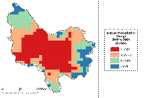

Figure 1. Projected change in mean annual air temperature (left panel) and annual precipitation (right panel) for the John Day River Basin according the A1B green-house gas emissions scenario.
Climate projections contribute to research elements 1, 2, 4 and 5 in our project by supporting the stream temperature modeling and prediction of fish responses. It also provides an important climatic context for other academic and state management activities in the John Day River Basin.
Synthesize LandsatTM and spatial (GIS) data
Land use/land cover of the John Day River Basin has been derived from Landsat Thematic Mapper (TM) satellite images to support other research elements of the project. The LandsatTM sensor system monitors seven bands of the electromagnetic spectrum expressly chosen for their utility in discerning vegetation characteristics, soil moisture conditions, among other parameters. The data have a spatial resolution of 30 m × 30 m. In addition, other spatial data sets (including elevation, geology, river network) have been acquired to support temperature and biological modeling efforts in Year 2.
Collate existing temperature data and deploy temperature loggers
Water temperature data for the John Day River has been quantified using a network of past and current digital temperature recorders at point locations. In June 2009 we deployed 95 temperature recorders (HOBO® Pendant Temperature/Light Data Logger) at major confluences, tributaries and other locations throughout the John Day River Basin (Figure 2). Loggers were programmed to record temperature at hour intervals. Stream data from the temperature recorders will provide information on daily and seasonal water temperature fluctuations, which is essential to support modeling efforts in Year 2. In addition, we have acquired longer-term temperature records from 448 loggers measuring water temperatures between 1993 and 2007 (record length and frequency varies).
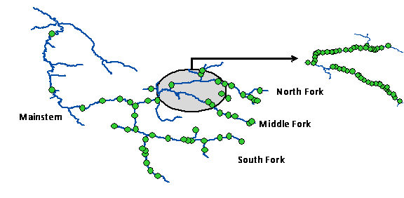
Figure 2. Location of the 95 temperature loggers deployed throughout the John Day River Basin in June 2009. Inset to the right represents the North and Middle Forks.
Taken together, we now have a comprehensive understanding of the spatiotemporal patterns in stream temperatures throughout the John Day River Basin. We continue to collect data to support additional modeling efforts. Model predictions using this data (conducted in Year 2) will be critical for projecting the future vulnerability of migration, spawning, and rearing stages of Chinook salmon and likelihood of spread by invasive fishes.
Develop theoretical underpinnings for prioritization framework
A central goal of our project is to combine future stream temperature predictions with species niche models to provide predictive insight into temperature-mediated invasions of non-indigenous fishes (i.e., smallmouth bass and northern pikeminnow) into critical habitat for Chinook salmon. With these predictions, we will classify the vulnerability of Chinook salmon (including migration, spawning, and rearing stages) across multiple scales to the direct effects of stream warming associated with climate and land-use change, and the indirect effects via temperature-mediated range expansion of bass and pikeminnow. In preparation for this outcome, we conducted a literature review to identify critical thermal thresholds and optima for our target species (Table 1).
Table 1. Stream temperature ranges and tolerances (presented in °C) for the study species.
| Parameter1 | Chinook salmon | Smallmouth bassd | Northern pikeminnowd | ||
| Egg/Alevin | Juvenile | Adult | |||
| Lower lethal limit | 1.7 | 0.8 | 0.8 | 10.0e | † |
| Lower tolerance limit | 4.0 | 4.5 | 3.3 | † | † |
| Lower growth limit | 4.5 | 10.0 | N/A | 20.2 | 16.1 |
| Preferred temperature | 6.0-10.0 | 12.0-13.3 | 7.2-14.5 | 25.0-26.0f | 18.1-22.8 |
| Upper growth limit | 12.8 | 15.6 | N/A | 27.0 | 24.4 |
| Upper tolerance limit | 14.4 | 19.1 | 21.0 | 29.5 | 26.0 |
| Upper lethal limit | 18.9 | 25.1 | 22.0 | 36.9 | 38.0 |
| Migration | N/A | N/A | 3.3-13.3a | N/A | N/A |
| Holding | N/A | N/A | 6.0-14.0b | N/A | N/A |
| Spawning | N/A | N/A | 5.6-12.8c | 12.8-20.0 | 13.0-15.0 |
Notes: 1 Lethal limits represent the temperature at which survival of a test group is 50% in a 10-min exposure, given a prior acclimation to temperatures within the tolerance zone. Tolerance zone is a set of temperatures for which species can tolerate without physiological damage. Growth zone is a set of temperatures for which growth is positive. Preferred is a set of temperatures for which the fish most frequently inhabits when allowed to freely select temperatures in a thermal gradient. Migration, holding and spawning is the set of temperatures during which these activities typically occur in natural populations.
† values to be determined from more extensive literature reviews;
a >21.0°C (19.0-23.9°C) represents a thermal barrier to migration;
b >15.0°C cause thermal stress in holding salmon;
c >12.8°C inhibits spawning, >16.0°C ceases spawning;
d Values are presented for adults unless otherwise noted. Values for other life-history stages will be determined (when possible) during the course of the study;
e Based on incubating eggs and larvae; f Preferred temperature for age-0 smallmouth bass is 29.0°C.
Our project aims to improve the scientific capabilities for guiding management strategies and policies aimed at minimizing the future range expansion of invasive species through protection (i.e., conservation easements) and restoration (i.e., riparian fencing) of riparian vegetation that creates/maintains coolwater habitat. We have developed a number of possible scenarios to examine the influence of climate change and riparian landuse on stream temperatures and subsequent biological responses (Table 2). These scenarios reflect discussions with various stakeholders in the John Day River Basin.
Table 2. Future management and climate scenarios that will be examined in the project.
| Scenario | Description |
| Future climate | Scenarios of projected temperature and hydrology |
| Future vegetation | Scenarios of projected land development |
| Restored vegetation | Complete restoration to estimated potential vegetation |
| John Day Fish Habitat Enhancement Program | |
| Conservation and acquisition priorities (TNC, TFT) | |
| Restored tributaries | Tributaries flow and temperature set to estimated potential |
| No PODS | No points of diversion |
| Ecological targets | Scenarios targeting specific ecological outcomes |
Develop species ecological niche models
Ecological niche models (interfaced within a GIS) will be used to predict future longitudinal distributions of Chinook salmon, smallmouth bass and northern pikeminnow in the Upper John Day River Basin. Currently, there are many statistical approaches that are suitable for ecological niche modeling, including traditional parametric approaches and non-linear machine learning methods. We have been conducting a series of analyses comparing different statistical approaches to modeling the presence/absence of each fish species as a function of water temperature and stream habitat. Preliminary results suggest that neural networks have a number of advantages over traditional parametric approaches, including their ability to accurately model non-linear data and accommodate complex interactions among predictor variables. Additional analyses will be needed prior to selecting a final approach.
Longitudinal fish and habitat surveys
We conducted an extensive fish and habitat survey in June 2009 to quantify the longitudinal distribution of fish species and essential habitat in the North and Middle Forks of the John Day River Basin (Figure 3). Continuous stream segments comprising 105 river kilometers were systematically surveyed to map and obtain counts of adult fish between June 16-24, 2009. Adult fish were located using two-person teams consisting of a diver, equipped with mask and snorkel, and an observer/data recorder on shore. Geographic locations of fish were recorded using a global positioning system with differential correction and 1:24 000 scale topographic maps. Habitat data collected included channel unit type (e.g., pool/riffle), instream cover (i.e., boulder, turbulence, large woody debris, and undercut banks), water temperature, depth, and dominant substrate composition for each channel unit. Additionally we deployed 50 temperature loggers, spaced at approximately 2 km intervals, to determine the longitudinal gradient of temperature over the study area.

Figure 3. Map of the John Day River showing the spatial extent of the fish surveys of the North Fork and Middle fork.
Overall, we documented the distribution of 12 species (Table 3) in late June. Smallmouth bass and juvenile chinook overlapped extensively in the downstream areas of our study area in mid June when flows were still high and temperatures relatively cool. Bass were found as far upstream as river km 76 on the North and river km 45 on the Middle Fork. We also discovered 87 bass nests in during late June over our 105 km study area (1.2 nests per km in the MF and 1.8 nests per km in the NF). We are currently developing a statistical model to predict bass occupancy and nest distribution based on habitat characteristics such as water velocity, depth, substrate, channel type and width, and river gradient.
Table 3. List of species observed during longitudinal stream surveys.
| Species | |
| Micropterus dolomieu | Catostomus columbianus |
| Ptychocheilus oregonensis | Catostomus macrocheilus |
| Richardsonius balteatus | Lampetra tridentate |
| Rhinichthys osculus | Oncorhynchus mykiss |
| Rhinichthys cataractae | Oncorhynchus tshawytscha |
| Cottus rhotheus | |
| Prosopium williamsoni |
Journal Articles:
No journal articles submitted with this report: View all 38 publications for this projectSupplemental Keywords:
RFA, Air, Ecosystem Protection/Environmental Exposure & Risk, Scientific Discipline, Aquatic Ecosystem, Aquatic Ecosystems & Estuarine Research, Ecological Risk Assessment, Atmosphere, Monitoring/Modeling, Air Pollution Effects, climate change, Environmental Monitoring, air quality, invasive species, Global Climate Change, socioeconomics, global climate models, climate model, atmospheric chemistry, coastal ecosystems, ecological models, climate variability, environmental measurement, land and water resources, ecosystem indicators, climate models, environmental stress, ecosystem stress, land use, meteorology, aquatic ecosystems, climatic influenceProgress and Final Reports:
Original AbstractThe perspectives, information and conclusions conveyed in research project abstracts, progress reports, final reports, journal abstracts and journal publications convey the viewpoints of the principal investigator and may not represent the views and policies of ORD and EPA. Conclusions drawn by the principal investigators have not been reviewed by the Agency.