
Grantee Research Project Results
Final Report: Effect of Sea Level Rise and Climate Variability on Ecosystem Services of Tidal Marshes
EPA Grant Number: R832220Title: Effect of Sea Level Rise and Climate Variability on Ecosystem Services of Tidal Marshes
Investigators: Craft, C. B. , Ehman, Jeffrey , Park, Richard , Joye, Samantha , Pennings, Steven
Institution: Indiana University - Bloomington , Pangaea Information Technologies, Ltd. , Eco Modeling , University of Georgia , University of Houston
Current Institution: Indiana University - Bloomington , Eco Modeling , Pangaea Information Technologies, Ltd. , University of Georgia , University of Houston
EPA Project Officer: Packard, Benjamin H
Project Period: April 1, 2005 through June 30, 2009
Project Amount: $749,974
RFA: Effects of Climate Change on Ecosystem Services Provided by Coral Reefs and Tidal Marshes (2004) RFA Text | Recipients Lists
Research Category: Aquatic Ecosystems , Ecological Indicators/Assessment/Restoration , Watersheds , Water , Climate Change
Objective:
Development of a conceptual model that describes how tidal marsh ecosystem services vary along the salinity gradient and a simulation model of how sea level rise and climate variability will affect the delivery of ecosystem services.Summary/Accomplishments (Outputs/Outcomes):
We employed field and lab measurements, geographic information systems (GIS) and simulation modeling using the Sea Level Affects Marshes Model (SLAMM) to investigate how tidal marsh area and delivery of ecosystem services will be affected by accelerated sea level rise (SLR) along the southeastern (Georgia) coast.
Our results suggest that different types of tidal marshes provide different levels of ecosystem services. Tidal freshwater and brackish marshes have higher macrophyte productivity & biodiversity, waste treatment (sediment deposition, N&P retention, denitrification), C sequestration and greenhouse gas (CO2, CH4) emissions than salt marshes (Figure 1).
SLAMM simulations using the IPCC mean estimate of SLR of 52 cm by 2100 suggest that tidal freshwater marshes will increase in area by 2% and salt marshes will decline in area by 20% (Table 1). Delivery of ecosystem services associated with productivity (macrophyte biomass), waste treatment (N accumulation in soil, potential denitrification), avian & plant biodiversity and other services also will decline (Table 2). An 82 cm increase in sea level, predicted by the A1B maximum scenario, leads to even greater reduction in tidal marsh area and delivery of ecosystem services. Based on this scenario, tidal freshwater, brackish and salt marshes decline by 39%, 1% and 45%, respectively, by 2100 (Table 1). Delivery of ecosystem services also is dramatically reduced under the A1B maximum scenario as macrophyte biomass decreases by nearly 550,000 MT/yr, N accumulation in soil decreases by 1482 MT N/yr and potential denitrification declines by 1072 Mt N/yr (Table 2). Under the A1B mean and max SLR scenarios, cumulative tidal marsh area declines by 12% and 33%, respectively, while cumulative reduction in delivery of ecosystem services is less, 4% to 28% (Table 2). Delivery of ecosystem services is less affected by accelerated SLR than tidal marsh area because brackish marsh area, which has high delivery of services per unit area, does not change much (-1% to +10%) relative to salt marshes that decline in area by 20% to 45%. This result highlights an unappreciated value of brackish marshes; because they support high levels of ecosystem services and do not decline as much as other tidal marsh types, they may buffer some of the negative impacts of SLR.
Dikes protect tidal marshes from SLR but services associated with connectivity, including waste treatment, habitat and refugia for estuarine nekton, are lost.
Climate and ecosystem services data collected between 2000 and 2006 from ten tidal marshes of the Georgia Coastal Ecosystem Long Term Ecological Research site indicate that freshwater, especially river discharge, enhances ecosystem services pertaining to macrophyte productivity & biodiversity and waste treatment (e.g. sediment deposition) (Table 3).
Our findings suggest that tidal marshes at the lower and upper salinity ranges, and their attendant delivery of ecosystem services, will be most affected by accelerated SLR unless geomorphic conditions (i.e. gradual increase in elevation) enable tidal freshwater marshes to migrate inland or vertical accretion of salt marshes increases to compensate for accelerated SLR.
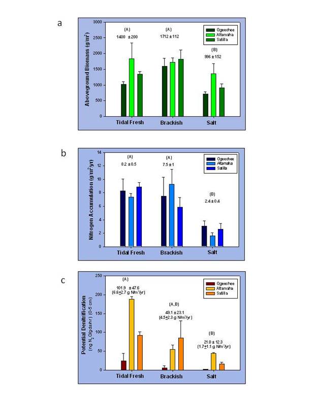
Figure 1. (a) aboveground biomass, (b) N accumulation in soil and (c) potential denitrification in tidal fresh, brackish and salt marshes of the three Georgia river systems. Means were separated using ANOVA followed by the Ryan-Einot-Gabriel-Welsch Multiple Range test (p<0.05). From Craft et al. (2009).
Table 1. Predicted change in area (km2) of selected (wet)land cover types along the Georgia coast in response to the A1B SRES sea level rise scenario as modeled by SLAMM. The simulation was run assuming the mean (52 cm) and maximum (82 cm) increase in sea level between 1999 and 2100. Differences in the initial areas of land cover types between the A1B Mean and Max simulations are the result of using IPCC projections that begin in 1990 and, thus, lead to small differences in the initial conditions based on the scenario (Mean versus Max) chosen. (From Craft et al. 2009).
| A1B Mean = 52 cm | A1B Max = 82 cm | |||||
| 1999 | 2100 | % change | 1999 | 2100 | % change | |
| Dry land | 5,008 | 4,385 | -12 | 5,006 | 4,265 | -15 |
| Non-tidal swamp | 1,838 | 2,089 | +14 | 1,837 | 2,106 | +15 |
| Tidal swamp | 413 | 316 | -24 | 407 | 267 | -34 |
| Inland fresh marsh | 64 | 65 | +2 | 64 | 63 | -2 |
| Tidal fresh marsh | 79 | 80 | +2 | 82 | 50 | -39 |
| Brackish marsh | 417 | 458 | +10 | 416 | 412 | -1 |
| Salt marsh | 1,116 | 890 | -20 | 1,106 | 610 | -45 |
| Trans. salt marsh 1 | 32 | 254 | +684 | 34 | 306 | +800 |
| Tidal flat | 11 | 26 | +146 | 11 | 177 | +1520 |
| Estuarine open water | 742 | 1,091 | +47 | 756 | 1,401 | +85 |
1 High marsh shrub vegetation flooded only during spring tides and storm tides.
Table 2. Predicted change in tidal marsh area and delivery of select ecosystem services along the Georgia (USA) coast between 1999 and 2100 in response to a 52 cm and 82 cm increase in sea level. Change in delivery of ecosystem services was calculated by multiplying the change in habitat area by the mean ecosystem service values for each marsh type in figure 1. Negative values denote a reduction in marsh area and delivery of ecosystem services. (From Craft et al. 2009).
| Habitat change (km2) |
Macrophyte biomass (Mt/yr) |
N sequestration in soil (Mt/yr) |
Potential denitrification (Mt/yr) |
|||||
| 52 cm | 82 cm | 52 cm | 82 cm | 52 cm | 82 cm | 52 cm | 82 cm | |
| Tidal fresh marsh | +1 | -32 | +1,400 | -44,800 | +8 | -262 | +7 | -211 |
| Brackish marsh | +41 | -4 | +70,200 | -6,800 | +307 | -30 | +184 | -18 |
| Salt marsh | -226 | -496 | -225,100 | -494,000 | -542 | -1188 | -384 | -843 |
| Cumulative (km2) | -184 | -532 | -153,500 | -545,600 | -227 | -1482 | -193 | -1072 |
| -12% | -33% | -8% | -28% | -4% | -23% | -4% | -25% | |
Table 3. Correlation of climate variables (freshwater discharge, salinity, precipitation, and temperature) to ecological indicators for the period 2000 to 2006 (6 yrs.). Values in bold are significant at p ≤ 0.05.
| Characteristic | Location | Discharge | Salinity | Precipitation | Temperature |
| Spartina alterniflora Aboveground Biomass |
Plain Levee All |
+0.190 +0.395 +0.276 |
-0.356 -0.176 -0.251 |
+0.158 +0.032 +0.055 |
-0.032 -0.145 -0.095 |
| Crab hole Density | Plain Levee All |
+0.077 -0.179 -0.0447 |
+0.130 +0.336 +0.239 |
-0.071 +0.141 +0.0316 |
-0.084 +0.110 +0.0 |
| Sediment Deposition | Plain | +0.366 | +0.045 | +0.230 | -0.202 |
| Sedimentation-erosion Tables (SET’s) |
All | +0.016 | -0.012 | +0.077 | +0.082 |
SLAMM-View
We developed a web-mapping application, “SLAMM-View”, to enable the public to visualize how different scenarios of sea level rise (SLR) affect coastal wetlands (and uplands) at varying spatial scales along the GA-SC coast. SLAMM-View portrays pairs of simulation results in conjunction with other thematic (land cover) layers which provide context. SLAMM-View allows the user to choose one of the 45 output pairs in a dual “live” map display: either from the same year (e.g., 2100) but from different scenarios (e.g., a 0.5 m SLR and a 1 m SLR), or from different years within the same scenario (e.g., base year 2000, and year 2100 under a 1 m SLR). The zooming and panning tools allow the user to focus the inquiry on their particular locality of interest, be it a large region encompassing both Georgia and South Carolina, or a small barrier island. One unique aspect of this web-mapping tool, vital to facilitating a comparison between the selected pair of simulation results, is that the dual maps are geographically-linked: zooming or panning in one map causes an identical action in the other map (see Figure 2).
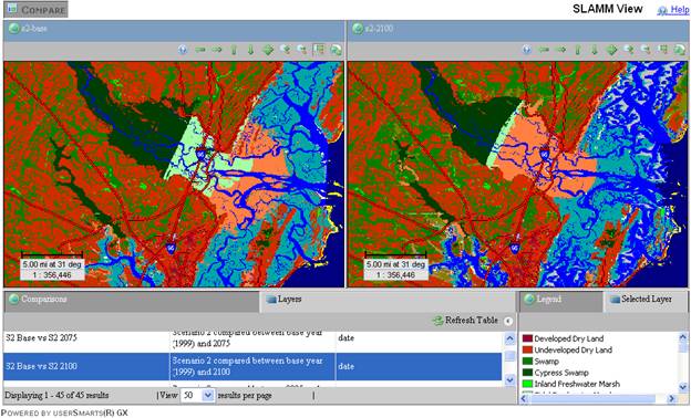
Figure 2. A screenshot of the SLAMM-View application showing the Altamaha estuary at baseline (left), and conditions at year 2100 under the A1B Maximum (SLR) scenario.
SLAMM-View is a browser-based application utilizes a combination of server and client software (Java and Java-script) based on Image Matters userSmarts® technology. The ACSII formatted output was converted to PNG (Portable Network Graphics), an extensible file format for the lossless, portable, well-compressed storage of raster images. This provides for fast rendering of the large gridded maps over the Internet without any reduction in the detail when viewed at local scales. The application accesses contextual layers such as state and county boundaries, roads, and NWI wetlands via web mapping services (OGC WMS), with adjustable layer transparency and a Layer control view that allows users to order and turn these ancillary layers on and off. SLAMM-View was developed to support Firefox, as well as both Internet Explorer 6 and 7 browsers. Server side software was installed, with support from Anna Radue and her colleagues at University Information Technology Services, at Indiana University. SLAMM-View can be accessed at: http://www.spea.indiana.edu/wetlandsandclimatechange/ or http://www.slammview.org.
Journal Articles on this Report : 12 Displayed | Download in RIS Format
| Other project views: | All 51 publications | 15 publications in selected types | All 12 journal articles |
|---|
| Type | Citation | ||
|---|---|---|---|
|
|
Brittain R, Craft C. Effects of Sea-Level Rise and Anthropogenic Development on Priority Bird Species Habitats in Coastal Georgia, USA. ENVIRONMENTAL MANAGEMENT 2012;49(2):473-482. |
R832220 (Final) |
Exit Exit |
|
|
Brittain R, Schimmelmann A, Parkhurst D, Craft C. Habitat Use by Coastal Birds Inferred from Stable Carbon and Nitrogen Isotopes. ESTUARIES AND COASTS 2012;35(2):633-645. |
R832220 (Final) |
Exit Exit |
|
|
Craft C, Clough J, Ehman J, Joye S, Park R, Pennings S, Guo H, Machmuller M. Forecasting the effects of accelerated sea-level rise on tidal marsh ecosystem services. Frontiers in Ecology and the Environment 2009;7(2):73-78. |
R832220 (2008) R832220 (Final) |
Exit Exit |
|
|
Crimmins MA, Comrie AC. Interactions between antecedent climate and wildfire variability across south-eastern Arizona. International Journal of Wildland Fire 2005;13(4):455-466. |
R832220 (Final) R828732 (2003) R828732 (Final) |
Exit |
|
|
Frost JW, Schleicher T, Craft C. Effects of nitrogen and phosphorus additions on primary production and invertebrate densities in a Georgia (USA) tidal freshwater marsh. Wetlands 2009;29(1):196-203. |
R832220 (Final) |
Exit Exit Exit |
|
|
Ket W, Schubauer-Berigan J, Craft C. Effects of five years of nitrogen and phosphorus additions on a Zizaniopsis miliacea tidal freshwater marsh. AQUATIC BOTANY 2011;95(1):17-23. |
R832220 (Final) |
Exit Exit |
|
|
Krull K, Craft C. Ecosystem development of a sandbar emergent tidal marsh, Altamaha River Estuary, Georgia, USA. Wetlands 2009;29(1):314-322. |
R832220 (Final) |
Exit Exit |
|
|
Krull K, Kraft C. Ecosystem Developmet of a Sandbar Emergent Tidal March, Altamaha River Estuary, Georgia, USA. WETLANDS 2009;29(1):314-322. |
R832220 (Final) |
Exit Exit |
|
|
Loomis MJ, Craft CB. Carbon sequestration and nutrient (nitrogen, phosphorus) accumulation in river-dominated tidal marshes, Georgia, USA. Soil Science Society of America Journal 2010;74(3):1028-1036. |
R832220 (Final) R826111 (Final) |
Exit Exit |
|
|
Tackett N, Craft C. Ecosystem Development on a Coastal Barrier Island Dune Chronosequence. JOURNAL OF COASTAL RESEARCH 2010;26(4):736-742 |
R832220 (Final) |
Exit |
|
|
Tackett N, Craft C. Ecosystem Development on a Coastal Barrier Island Dune Chronosequence. JOURNAL OF COASTAL RESEARCH 2010;26(4):736-742. |
R832220 (Final) |
Exit |
|
|
Wieski K, Guo H, Craft CB, Pennings SC. Ecosystem functions of tidal fresh, brackish, and salt marshes on the Georgia coast. Estuaries and Coasts 2010;33(1):161-169. |
R832220 (Final) |
Exit Exit |
Supplemental Keywords:
RFA, Air, Scientific Discipline, Ecosystem Protection/Environmental Exposure & Risk, Aquatic Ecosystem, Aquatic Ecosystems & Estuarine Research, Ecological Risk Assessment, Chemistry, Atmosphere, Monitoring/Modeling, Air Pollution Effects, climate change, global ciruclation model, South Atlantic Coast, Global Climate Change, climate model, global climate models, global change, atmospheric chemistry, ecological models, coastal ecosystems, environmental monitoring, climate models, environmental measurement, climate variability, ecosystem indicators, habitat preservation, environmental stress, ecosystem stress, meteorology, aquatic ecosystems, climatic influence, coral reef communities, sea level rise, climateProgress and Final Reports:
Original AbstractThe perspectives, information and conclusions conveyed in research project abstracts, progress reports, final reports, journal abstracts and journal publications convey the viewpoints of the principal investigator and may not represent the views and policies of ORD and EPA. Conclusions drawn by the principal investigators have not been reviewed by the Agency.