
Grantee Research Project Results
2009 Progress Report: Beach Grass Invasions and Coastal Flood Protection: Forecasting the Effects of Climate Change on Coastal Vulnerability
EPA Grant Number: R833836Title: Beach Grass Invasions and Coastal Flood Protection: Forecasting the Effects of Climate Change on Coastal Vulnerability
Investigators: Seabloom, Eric , Ruggiero, Peter , Hacker, Sally
Institution: Oregon State University
EPA Project Officer: Packard, Benjamin H
Project Period: July 1, 2008 through June 30, 2012 (Extended to June 30, 2013)
Project Period Covered by this Report: July 1, 2008 through June 30,2009
Project Amount: $599,980
RFA: Ecological Impacts from the Interactions of Climate Change, Land Use Change and Invasive Species: A Joint Research Solicitation - EPA, USDA (2007) RFA Text | Recipients Lists
Research Category: Aquatic Ecosystems , Climate Change
Objective:
Increased storm severity and sea level-rise resulting from climate change have greatly elevated the risk to coastal communities of catastrophic flooding and storm damage. These risks have been exacerbated by alterations to coastal ecosystems and the introduction of exotic species. In the Pacific Northwest, coastal dunes protect about half of the coastline, and our initial results suggest that climate change-induced sea level rise could double the frequency with which waves overtop dunes. Intentional planting of exotic grasses may have initially increased coastal protection from flooding by building tall foredunes parallel to the shoreline. However, an unintentional second invasion appears to be decreasing foredune height by roughly 50%, thereby increasing risk exposure. In addition, many agencies are removing exotic beach grasses to restore habitat for imperiled species listed in the Endangered Species Act. The effects of these conservation actions on flooding risk are unknown.
Managers of West Coast dune systems are faced with an apparent conundrum. Climate change is increasing the need for the protection services for exotic dominated coastal dunes, but conservation mandates the removal of invasive beach grasses to favor recovery of threatened and endangered species (Figure 1).
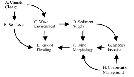
Figure 1. Pathways addressed in the proposed research linking climate change, species invasions, conservation and management, and risk of flooding in coastal communities.
Furthermore, the uncontrolled invasion by the second grass, A. breviligulata, is associated with large declines in dune height and biodiversity. Despite the conflicting values of coastal protection and conservation, neither invasive species dynamics nor coastal protective values have been quantified under future invasion and climate change scenarios. Here we propose research to address three fundamental questions about the interactions among invasion dynamics, climate change and variability, and societal risk.
Question 1. Will climate change alter the invasion dynamics of exotic beach grasses through its effects on sediment supply (A → G; Fig. 1)?
Question 2. Will beach grass invasion alter the flood protection services provided by coastal dunes by altering dune morphology (G → E; Fig. 1)?
Question 3. Will exotic beach grass management affect protection services provided by coastal dunes by altering dune morphology (H → E; Fig. 1)?
To answer these questions, we are conducting experiments and observational studies to
achieve the following objectives:
Objective 1. Determine the effects of climate change on exotic beach grass invasion;
Objective 2. Determine the effects of exotic beach grass invasion on coastal vulnerability; and
Objective 3. Determine if conservation management alters coastal vulnerability to flooding under a range of climate change, invasion, and management scenarios.
Progress Summary:
Objective 1. Determine the effects of climate change on exotic beach grass invasion
We are just beginning the experiments associated with this objective, and have no direct findings at this time. However, we have made great headway assembling the shoreline change data, coastal geomorphological data, and vegetation data necessary to conduct these analyses. The coastal geomorphological data are based on lidar, and developing computer algorithms for automated analyses of these rich but vast data sets has been challenging. However, we now have the capacity to develop continuous dune profiles for Oregon and Washington and these newly generated data will be the base of our coastal hazard assessment.
Ojective 2. Determine the effects of exotic beach grass invasion on coastal vulnerability
As a first step to achieve this objective, we have linked a set of our vegetation surveys with shoreline change data. We conducted detailed topographic surveys of the foredunes along 19 sites ranging from Grays Harbor, Washington, to Cape Blanco, Oregon. The sites fall within littoral cells or areas along the coast with the same geological sediment sources and sinks. The three largest littoral cells on the coast include the Columbia River Littoral Cell (CRLC) (Point Grenville, Washington, to Tillamook Head, Oregon), the Coos Bay Littoral Cell (CBLC) (Heceta Head to Cape Arago, Oregon), and the Bandon Littoral Cell (BLC) (Cape Arago to Cape Blanco, Oregon) where massive sand deposition has occurred over the Holocene (Komar, 1997). Smaller littoral cells within the central Oregon coast are bracketed by rocky headlands and include the Netarts Littoral Cell (NetLC) (Cape Meares to Cape Lookout, Oregon), Sand Lake Littoral Cell (SLLC) (Cape Lookout to Cape Kiwanda, Oregon), the Neskowin Littoral Cell (NesLC) (Cape Kiwanda to Cascade Head, Oregon), and the Newport Littoral Cell (NewLC) (Yaquina Head to Cape Perpetua, Oregon).
Short-term (decadal-scale) and long-term (century-scale) shoreline change rates have been developed for all sandy beaches along the Oregon and Washington Coasts. Initially we are linking our short-term rates, taken here as a proxy for sediment availability, with the vegetation surveys at all transects at all sites. These change rates have been calculated from shoreline position data that have been derived from both aerial photographs, 1950s/1960s era shoreline position, and lidar data, 2002 datum based shoreline.
The foredunes dominated by A. breviligulata had a significantly different shape than those dominated by A. arenaria. A. arenaria foredunes were half the height, twice the width, and half as steep (t1,73 = 9.6, P = 0.0001) as A. breviligulata dominated sites. Foredunes dominated by A. breviligulata had higher sand deposition and greater shoreline change than those dominated by A. arenaria.
We found a strong negative exponential correlation between shoreline change rate and maximum foredune height across all sites. Transects experiencing highly positive shoreline change (prograding shorelines) had low foredunes, however these sites were all dominated by A. breviligulata. To remove this confounding between species identity and shoreline change, we conducted a second analysis using transects with shoreline change rates of 1 meter or less, where we had adequate data on both species. A. arenaria dominated foredunes were significantly taller than A. breviligulata dominated foredunes within this restricted data as in the total data set. There were no differences among the Ammophila species in the percent cover of grass, maximum foredune width, or foredune slope within this same subset of foredunes.
In addition, we have been developing a suite of analytical tools needed to make use of the extensive lidar data collected along the coastal dunes of the PNW. We have refined automated techniques to accurately extract characteristic dune features from hundreds to thousands of profiles within each littoral cell (transect spacings can be as low as 20m). We are computing all relevant morphometric parameters including foredune crest elevations, dune toe elevations (the junction between backshore and the dune face), dune heel elevations (a local minimum landward of the dune crest), and various measures of dune slope and volume. The dune toe is particularly relevant for computing storminduced dune erosion and is found by detrending the cross-shore profile with a cubic function and finding the maximum difference between the original profile and detrended profile. This minimum point corresponds to the inflection point between the backshore and dune face. We are also interested in the width of the dune at the base and the slopes of the foreshore beach face, the backshore beach face, and the dune face as these parameters characterize the shape and scale of each dune and the beach type. We have used the Mean High Water (MHW) position as the shoreline position for each profile.
We have also completed a more extensive survey of vegetation in summer of 2009. Our next step in achieving this Objective is to link the vegetation survey data with the updated lidar data and associated risk metrics. This will allow us to estimate the effects of exotic species on flooding risk in coastal communities.
Ojective 3. Determine if conservation management alters coastal vulnerability to flooding under a range of climate, invasion and management scenarios
We surveyed 10 snowy plover habitat restoration areas ranging from Leadbetter Point (46 ° 38 ' 36.11 " N, -124 ° 4 ' 9 " W) at the tip of the Long Beach Peninsula, in Washington, to Elk River (42 ° 47 ' 20.39 " N, -124 ° 31 ' 27.98 " W) in southern Oregon. Ammophila removal treatments included bulldozing, herbicide application, hand-pulling, salt water application. The habitat restoration is carried out by each landowner (Bureau of Land Management, U.S. Fish and Wildlife Service, National Forest Service, and State of Oregon) and the plover monitoring is overseen by the U.S. Fish and Wildlife Service.
Ammophila removal significantly altered dune morphology. Maximum dune elevation dropped by roughly 3 m in treated areas. Treated areas were flatter as a result of bulldozing, which occurred at least once and as many as 11 times at each site. Treatments also significantly reduced Ammophila relative abundance within treatment areas by one-third (p=0.002. However, mean Ammophila relative cover did not respond differently to any treatment type or intensity. Ammophila was by far the dominant cover species in both treatment and control sites; other species’ relative abundance was negatively associated with Ammophila (Pearson correlation test control: p=0.005, 7df, t=-3.973; treatment: p=0.019, 7df, t=-3.042; Fig. 3D).
Future Activities:
Ojective 3. Our next step in these analyses is to calculate the change in flooding risk associated with these altered dune profiles.Journal Articles on this Report : 3 Displayed | Download in RIS Format
| Other project views: | All 55 publications | 19 publications in selected types | All 17 journal articles |
|---|
| Type | Citation | ||
|---|---|---|---|
|
|
Kaminsky GM, Ruggiero P, Buijsman MC, McCandless D, Gelfenbaum G. Historical evolution of the Columbia River littoral cell. Marine Geology 2010;273(1-4):96-126. |
R833836 (2009) R833836 (Final) |
Exit Exit |
|
|
Ruggiero P, Buijsman M, Kaminsky GM, Gelfenbaum G. Modeling the effects of wave climate and sediment supply variability on large-scale shoreline change. Marine Geology 2010;273(1-4):127-140. |
R833836 (2009) R833836 (Final) |
Exit Exit Exit |
|
|
Ruggiero P, Komar PD, Allan JC. Increasing wave heights and extreme value projections:the wave climate of the U.S. Pacific Northwest. Coastal Engineering 2010;57(5):539-552. |
R833836 (2009) R833836 (Final) |
Exit Exit |
Supplemental Keywords:
Land, soil, sediments, global climate, marine, risk assessment, ecological effects, human health, ecosystem protection, indicators, restoration, terrestrial, aquatic, habitat, risk management, public policy, decision making, environmental assets, marine science, biology, physics, engineering, ecology, modeling, monitoring, surveys, climate models, remote sensing, Northwest, OR, Oregon, WA, Washington, EPA Region 10, invasion, coastal sand dune, non-native congeners, beach grasses, Ammophila arenaria,
Ammophila breviligulata, community structure, shoreline change, sand accretion, foredune, coastal protection, ecosystem services
Relevant Websites:
Research Websites of Principal Investigators.
Sally Hacker:
Peter Ruggiero:
Eric Seabloom:
Other Websites Related to Research Objectives
2008 Pacific Northwest Coastal Dunes Workshop:
Progress and Final Reports:
Original AbstractThe perspectives, information and conclusions conveyed in research project abstracts, progress reports, final reports, journal abstracts and journal publications convey the viewpoints of the principal investigator and may not represent the views and policies of ORD and EPA. Conclusions drawn by the principal investigators have not been reviewed by the Agency.