
Grantee Research Project Results
2008 Progress Report: Elevated Temperature and Land Use Flood Frequency Alteration Effects on Rates of Invasive and Native Species Interactions in Freshwater Floodplain Wetlands
EPA Grant Number: R833837Title: Elevated Temperature and Land Use Flood Frequency Alteration Effects on Rates of Invasive and Native Species Interactions in Freshwater Floodplain Wetlands
Investigators: Richardson, Curtis J. , Qian, Song S. , Ho, Mengchi , Flanagan, Neal
Current Investigators: Richardson, Curtis J. , Flanagan, Neal , Ho, Mengchi
Institution: Duke University , Nicholas School of the Environment and Earth Sciences
EPA Project Officer: Packard, Benjamin H
Project Period: April 1, 2008 through March 31, 2011 (Extended to March 31, 2012)
Project Period Covered by this Report: April 1, 2008 through March 31,2009
Project Amount: $598,107
RFA: Ecological Impacts from the Interactions of Climate Change, Land Use Change and Invasive Species: A Joint Research Solicitation - EPA, USDA (2007) RFA Text | Recipients Lists
Research Category: Aquatic Ecosystems , Ecological Indicators/Assessment/Restoration , Climate Change
Objective:
The primary objective is to assess how predicted climate and land use driven changes in hydrologic flux and temperature regimes of floodplain ecosystems affect plant communities in terms of their vulnerability to the establishment and spread of invasive species, and in turn ecosystem functions and services. Future climate scenarios for the southeastern United States predict that surface water temperatures will warm (in concert with air temperature) and that stream flows will likely decrease, with a greater proportion of annual watershed hydrologic yield occurring during major storm events. Land use changes (urban vs. forested etc.) have been shown to also raise water temperature and increased pulsed water releases during storms.Specifically, we focus on the relationships between native species composition, diversity, productivity, and invasibility of floodplain ecosystems affected by alterations of water temperature and annual hydrographs driven by climate change and land use change (urban, forested and agricultural). We will use a combination of varying scale experimental studies and one novel large-scale regional study to verify our experimental and threshold modeling results.
Progress Summary:
Experimental Level 1 (elevated temperature and pulsed water). The runoff from an urban watershed (58 ha) provides conditions for examining the effects of temperature and hydrographs on changes in plant community composition, species invasions, and productivity and nutrient dynamics not possible in more unregulated settings. To address climate change effects, we have constructed a symmetrical stream and restored a riparian wetland treatment ecosystem that is divided into 3 connected wetland cells down each side of the restored stream. One side of this uniquely designed treatment floodplain is heated, and comparisons in the behavior of the two halves (heated and unheated water) will be used to test for the hypothesized shifts in species composition, diversity and ecosystem thresholds. Water is drawn from the adjacent stream, heated, and then circulated via pipes lying at the ground wetland surface, but beneath at least 15 cm of water. Water levels are maintained in each cell with flashboard risers. The system is analogous to hot water under floor heating technologies where a temperature controller relays for more warm water when the set temperature is not maintained. All heated water is re-circulated, in a closed system such that heat will dissipate into the treated systems without the addition of any actual water.
The experiment design consists of matched cells, each approximately 20m x 5m, one heated and one unheated (Figure 1). The heated cell has a grid of 4.8 m – 4.5m x 1.95 cm diameter copper
pipes that re-circulate heated water pumped from an 1892 liter (500 gallon)
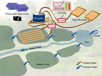
Figure 1. A depiction of the experimental cells in the Duke Forest SWAMP site used for the wetland cell water heating treatments holding tank to the grid by selective valves. Each valve controls 4 heated pipes that are 4 cm above the soil/sediment layer within a naturally flooded zone. Two temperature monitors in the reference cell control the valves to keep the temperature 3-5 ºC higher in the heated cell. There is a gradual slope in each cell; regulating the outlet standpipe can control the water depth in each cell. Water for the storage tank is heated automatically by solar panels (Silicon Solar Evacuated Tube collectors) and the heated water is re-circulated as needed. A photovoltaic cell powered pump (Swiftech #MCP655) circulates water from the tank to the solar tube collectors’ and back to the tank. The heated tank water is pumped into the grid from the tank by a solar recharged battery-powered pump (Shurflow #2088) and is controlled by four latched valves (Alcon series #985A-243N). The valves are controlled by a Campbell Scientific controller (CR1000) that monitors the temperature of the reference and heated cells and controls the heating grid valves to maintain a temperature difference of 3-5 ºC on the heated wetland cell compared to the ambient cells. The batteries, Shurflow pump; Campbell controller and latched valves are contained in a large construction site locked storage bin to provide security and weather protection.
The temperature elevation to be utilized above background in our initial tests is 3-5 °C; a predicted range of stream change from global climate effects (IPCC 2001), but the actual elevated temperature range that can be held is currently being determined with test trials. One test run has been completed and initial trials indicate that warmer water (5° ± 1) above background can be maintained in the spring and summer months. Over the next year we will elevate stream and wetland surface water temperatures and model the rates of species invasions, plant community shifts, determine threshold conditions as well as assess differences in nutrient inputs, outputs, retention rates and transformation throughout a warmed wetland compared to a non-warmed wetland within the SWAMP site in Duke Forest. The water quality and flow dynamics of this stream have been monitored for four years prior to restoration thus providing a long-term basis for assessing upstream watershed inputs, temperatures, and flood frequencies.
Level 2 Experimental Level 2 (regional floodplain hydrology and temperature shifts). We have identified nine synoptic sites located on river flood plains throughout the North Carolina and southern Virginia (Roanoke River Basin). These sites are in two categories: a) three sites are located downstream of reservoirs used as flood storage and cooling water supplies for coal-fired or nuclear power plants, and where outflow is drawn from warmer surface water layers of the reservoir [Lake Norman, Lake Wylie, and Gaston Lake], and b) three sites are located downstream of hydroelectric plants where outflow is drawn from deeper (cooler) strata nearer the lake bottom [John H. Kerr Reservoir, Smith Mountain Lake, and the Philpott Reservoir (VA)] (Figure 2).
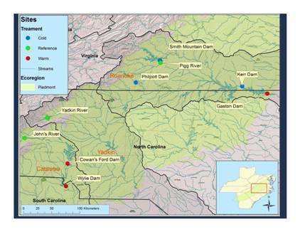
Figure 2. A map of the riparian study site locations on cold, warm and reference streams in Virginia, North Carolina and South Carolina.
Floodwaters in the first groups of sites are significantly warmer than those from the second group by > 5° C degrees. For example, during most summer periods, the water temperatures released from the Smith Mountain hydro plant are less than the 20ºC, while summertime water temperatures at Lake Wylie average 25o (Figure 3). We use differences in temperature and hydroperiod [flood storage dams versus hydroelectric dams] to examine effects of temperature and flood frequency on floodplain riparian plant communities and ecosystem functions, with an emphasis on the effects of warmer water on invasive species and plant community shifts.
Plant surveys were performed in the fall of 2008 on all regional wetland sites. Surveys were performed on 10 meter transects using line intercept methods. The elevation of the beginning, middle and end points of each transect was recorded using survey equipment and related to a fixed datum on the site water-level recorder. Our sites were divided into two vegetation zones; emergent and riparian. The emergent zone begins at the lower boundary of persistent emergent vegetation and is dominated by sedges, reeds, and mudflat species. The riparian zone occurs at a slightly higher elevation were the plant community is dominated by grasses, clonal dominant species, and occasional shrubs. The operational boundary of the emergent and riparian plant zones was an elevation of 20 centimeters above the lower boundary of the emergent zone. The upper boundary of the emergent zone is a typically abrupt line where woody species become dominant.
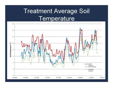
Figure 3. Average soil temperature in the riparian wetlands along the warm, cold and reference streams.
We have installed a water-level recorder at each site and are evaluating flood depth and return intervals using leveling survey techniques to estimate to relative elevation of plant survey points and the zero datum of the water level recorder so that the water level recorder data can be used to predict when plant survey plots are submerged or exposed.
Three replicate soil samples were collected from each vegetation zone in the fall of 2008. Soil samples were stored at 4o C between sampling and analysis (less than 1 week). Half of each core was dried at 105oC for 24 hours to determine the moisture content. The remaining half was held at field moisture and passed through a sieve (2 mm). Soil and sediment pH were measured with a glass electrode in a 1:2 soil: water slurry. The field-moist sieved soil was analyzed for 2M KCl extractable nitrate+nitrite –N (NO3-N) and ammonium (NH4-N) on a Bran and Lubbe TRAACS autoanalyzer and for soluble organic carbon and nitrogen with a Shimadzu TOC 5000 solution C analyzer equipped with a TN module. Total C and N content were measured (Carlo-Erba NA 1500 CNS analyzer) and results expressed on a per gram dry soil/sediment basis.
Water grab samples were collected quarterly through the first year at all sites and analyzed for TN, NO2- NO3, TP, and TDP. In addition, in-situ measurements of pH, specific conductivity, temperature, and DO were recorded. Three additional soil cores were collected in each of the vegetation zones (emergent and riparian) were analyzed for bulk density, texture, moisture content, In addition feldspar sedimentation plates have been installed at 9 locations to test for annual sediment retention differences.
Soil temperature is being measured at two different elevations at each project site. Temperature loggers have been installed at the lower limit of emergent herbaceous vegetation at each site (marsh zone). A second temperature logger has installed at an elevation approximately 20 centimeters higher (riparian zone). Soil probes are located in areas that are not under a woody canopy and placed at a probe depth of 10 centimeters with temperature logged every 15 minutes. Soil temperatures are being used to calculate accumulated soil growing degree days (SGDD) that are being used to compare the thermal balances between warm and cold riparian sites.
Expected Results. At the end of this study we will have an extensive dataset across multiple years and several spatial scales that can be used to explore the feedbacks occurring in floodplains where invasive species have become established, and how these feedback processes enhance the ability of invasive species to persist and spread? We propose several powerful statistical techniques to relate changes in abiotic variables to shifts in community composition and ecosystem functions. Bayesian multilevel change point analysis a statistical modeling methodology for detecting abrupt changes in variables of interest will be used to explore factors influencing the variability in threshold for species shifts in each community.
Future Activities:
We will continue data collection using our established protocols and applying adaptive management approaches as required. In year two, we will present year 1 and 2 results at national meetings and are currently preparing manuscripts for submission to peer-reviewed scientific journals.Journal Articles:
No journal articles submitted with this report: View all 9 publications for this projectSupplemental Keywords:
wetlands, watershed, land use, climate change, invasive species, temperature shifts, pulsed water, water quality, altered stable states, nonlinear thresholds., RFA, Ecosystem Protection/Environmental Exposure & Risk, Air, Scientific Discipline, Ecological Risk Assessment, Atmosphere, Regional/Scaling, Monitoring/Modeling, Air Pollution Effects, Atmospheric Sciences, Hydrology, climate change, Environmental Monitoring, invasive species, biodiversity, Global Climate Change, ecosystem assessment, climate model, water quality, coastal ecosystem, global change, atmospheric chemistry, ecological models, coastal ecosystems, climate models, environmental measurement, climate variability, habitat preservation, environmental stress, UV radiation, habitat diversity, anthropogenic, meteorology, land use, regional anthropogenic stresses, greenhouse gasesRelevant Websites:
Duke University Wetland Center website www.env.duke.edu/wetlandProgress and Final Reports:
Original AbstractThe perspectives, information and conclusions conveyed in research project abstracts, progress reports, final reports, journal abstracts and journal publications convey the viewpoints of the principal investigator and may not represent the views and policies of ORD and EPA. Conclusions drawn by the principal investigators have not been reviewed by the Agency.