
Grantee Research Project Results
Final Report: Effects of natural and anthropogenic processes on Tillamook Bay and its watershed: An integrated process study and land-use perspective
EPA Grant Number: R825751Title: Effects of natural and anthropogenic processes on Tillamook Bay and its watershed: An integrated process study and land-use perspective
Investigators: McManus, James , Komar, Paul , Ford, M. Jesse , Smith, Courtland
Institution: Oregon State University
EPA Project Officer: Packard, Benjamin H
Project Period: October 1, 1997 through September 30, 2000 (Extended to September 30, 2001)
Project Amount: $749,995
RFA: Water and Watersheds Research (1997) RFA Text | Recipients Lists
Research Category: Watersheds , Water
Objective:
The five major rivers entering into Tillamook Bay drain 139,600 ha of similar geologic terrain; however, the land-use practices vary significantly among the different riverine watersheds. One river runs through the urban center of Tillamook, whereas the river to the south is heavily influenced by dairy farming activities. The northern-most three rivers experience progressively less urban and agricultural activities within their lower watersheds.
Within the framework of examining the relative influence of different watershed activities on processes occurring within the Tillamook Basin, we proposed testing a number of hypotheses aimed at assessing the importance of "natural" versus "anthropogenic" processes on the Bay's ecosystem. Our hypotheses were guided by "perceptions" of the ecosystem's behavior by the local residents. More specifically, we were targeting the following issues: (1) Have land-use practices significantly altered the sedimentary budget of the Tillamook Bay watershed? (2) Are carbon, nutrient, and trace metal cycles significantly different among the five major river systems feeding the Tillamook estuary because of the different land use practices? (3) Have differences in land use management practices between the Tillamook and Kilchis River sub-basins of the Tillamook Bay watershed have led to quantifiable differences in aquatic ecosystem health and biotic integrity in the riverine and stream environments of these sub-basins? (4) Are there differences between local knowledge and scientific observation, and if so, why? Can actions to clarify knowledge contexts resolve differences?
Summary/Accomplishments (Outputs/Outcomes):
The major scientific findings from this project are in four areas. These are:
• The role that the ocean processes play in estuarine processes.
• The anthropogenic influence on water quality of Tillamook Rivers and the Bay.
• The influence of land use activities on in-stream condition.
• The interaction between scientific information and local knowledge.
In addition to scientific findings, the project also developed outreach activities in Tillamook County that sought to improve the exchange of information between scientists and the public. These activities included initiating an outreach task force for the Tillamook County Performance Partnership; experimenting with the PLACE mapping learning technique; and developing the salmon cycle learning game for school children.
Sedimentation: Natural Versus Anthropogenic Processes
Tillamook Bay on the Oregon coast is an unusual estuary in that it has five significant rivers that drain into it. There have been substantial human impacts in the watersheds, especially by Euro-Americans who first settled there during the middle of the 19th century. The initial impacts came in the lowlands, close to the Bay, with the clearing of forests to provide agricultural land, which was further improved by controlling floods on the rivers through the removal of woody debris and the construction of levees. Later, the impacts shifted to the upper watersheds in the steep terrain of the Coast Range mountains. Commercial logging initiated the removal of the forests, but the main impacts resulted from a series of devastating fires between 1933 and 1951. Reforestation during the past 50 years has generally improved the watersheds, although some clear cutting continues.
Analyses of precipitation data and discharge measurements on the Wilson River from 1931 to the present demonstrate that discharges were enhanced by approximately 13 percent during the Heavily Impacted Period (1931-1954) compared with the Normal Period (1977-present) after reforestation (Styllas, 2001; Komar, et al., submitted; Styllas and Komar, submitted). Calculations of potential annual sediment yields were found to be approximately 29 percent greater during the Heavily Impacted Period. The actual sediment yields were certainly less than the calculated potential volumes due to limited sand availability in the watershed, but it is also likely that the difference between the Heavily Impacted and Normal Periods was greater than 29 percent because more sand would have become available due to the human impacts.
Of interest was the possibility of relating the quantities of sand derived from the five rivers to different degrees and types of land-use practices in their watersheds (Komar, et al., submitted; Styllas and Komar, submitted). Our research therefore initially focused on the possibility of distinguishing between the sands contributed by the five rivers through detailed analyses of grain-size distributions, mineral compositions, and geochemical tracers. Those efforts were unsuccessful because of the near uniformity of rock types found in the watersheds. We were able to contrast the river-derived sand, which is primarily rock fragments, from the quartz and feldspar sand that is carried into Tillamook Bay from the ocean beach. Analyses of surface sediment samples collected throughout the Bay established that they are dominantly muddy sand to pure sand. Therefore, while the rivers supplied large quantities of clay and silt, most of that fine-grained sediment has been flushed through the Bay. Sand derived from the ocean beach dominates the Bay sediment near the active inlet and in the southwestern part of the Bay where Bayocean Spit breached during 1952-1956. The eastern half of the Bay is dominated by river-derived rock fragments, principally because the combined channels of the four largest rivers enter the Bay at its southeast corner, and the subsequent transport hugs the eastern shore as the water flows toward the inlet. When the surface samples are integrated across the Bay, it is found that about 60 percent of the sand is derived from the ocean beach and 40 percent from the five rivers. Several cores also were collected, and the expectation was that they would reveal higher percentages of riverine sand in that the primary inputs of sediments from the watersheds would have occurred during the first half of the 20th century due to logging and forest fires. Just the opposite was found, with generally increasing percentages of beach sand down core and less river-derived sand. The cores also provided evidence for episodic inputs of large quantities of beach sand. The Oregon coast lies within the zone of subduction of the Juan de Fuca oceanic plate beneath the North American plate, and it is well established that subduction earthquakes and tsunami have struck the area repeatedly during the past several thousand years, with the most recent event having occurred in January 1700. The release by the earthquake of the accumulated subduction strain produced an abrupt subsidence of the land by about 1 meter, increasing water depths in the Bay. Within minutes after the earthquake, a tsunami would have swept across the Bay, carrying beach sand into the deepened water. For decades or longer thereafter, normal storms could have washed over the spit, carrying additional sand into the Bay. Thus, while human impacts in the watersheds of the rivers that drain into Tillamook Bay have been important to sediment delivery and Bay shoaling, the impacts of the subduction earthquake in 1700 appear to have been greater.
Estuarine and Watershed Geochemistry
Tillamook Bay receives fresh water input from five rivers and exchanges ocean water through a single channel. Similar to other western U.S. estuaries, the Bay exhibits a strong seasonal change in river discharge in which there is a pronounced winter maximum and summer minimum in precipitation and runoff. The behavior of major inorganic nutrients (P, N, Si) within the watershed was examined over seasonal cycles and under a range of river discharge conditions from October 1997 through December 1999. Monthly and seasonal sampling stations included transects extending from the mouth of each river to the mouth of the estuary as well as from 6-10 sites along each of the five major rivers.
Nutrient behavior in the Tillamook Bay estuary can be explained by two dominant factors: estuarine flushing time and biological uptake and regeneration (Colbert and McManus, submitted; Colbert, in preparation). Superimposed on these two processes is seasonal variability in nutrient concentrations of coastal waters via upwelling (P, N). Estuarine flushing time determines the amount of time for the uptake of nutrients by phytoplankton, exchange with suspended particles, and interaction with the sediments. Seasonal coastal upwelling controls the timing and extent of oceanic delivery of nutrients to the estuary. Benthic regeneration of nutrients also is an important process within the estuary that occurs seasonally according to the flushing characteristics of the estuary. Silicic acid, nitrate, ammonium, and nitrite supply to the Bay appears to be dominated by riverine input. On the other hand, phosphate supply is dominated by river input during periods of high river flow (winter and fall months) with oceanic input via upwelling and tidal exchange important during other times (spring and summer months). Internal sources of dissolved inorganic phosphorus and nitrogen also are significant throughout the annual cycle. Phosphorus runoff from agricultural lands and urban areas often leads to eutrophication of rivers, streams, and upper reaches of estuaries. Nitrite and ammonium concentrations in the rivers feeding Tillamook Bay were consistent with increased loading from agricultural and urban activities. We expected riverine phosphate concentrations also to be consistent with the eutrophication hypothesis. However, riverine phosphate concentrations feeding Tillamook Bay (0.15-1.01 M) were similar to phosphate concentrations reported for other Pacific Northwest estuaries with less agricultural and urban development. Thus, our findings suggest that variations in the ocean water source provides much of the variability in the supply of phosphorus to this system.
Dissolved and particulate manganese (Mn), barium (Ba), and iron (Fe) within the Tillamook Bay estuary were examined over seasonal cycles and under a range of river discharge conditions from January 1999 through December 1999 (Colbert and McManus, in preparation; Colbert, in preparation). Based on estuarine distributions and box model calculations, Mn, Fe, and Ba behavior within Tillamook estuary can be explained by two dominant factors: interaction with suspended particulate material and input from benthic sources. We attribute seasonal concentration differences in distribution patterns to changes in the relative importance of these two variables among seasons. Although Mn and Fe exhibit estuarine behavior typical for these elements, Ba shows a strong lower estuary source, likely the result of benthic interactions.
Fluxes of dissolved Mn, Fe, and Ba from the river to the estuary were related to river discharge rates with highest fluxes observed under winter conditions (Colbert and McManus, in preparation). On an annual average, dissolved Mn and Ba fluxes to the coastal ocean were increased by 390 and 170 percent, respectively, over conservative mixing predictions due to internal estuarine sources, while 47 percent of river-derived dissolved Fe was removed within the estuary. Under high flow, winter conditions, total fluxes of Mn, Fe, and Ba were significantly reduced within the estuary due to removal at the river water-salt water interface. During all other months, box model calculations indicated that total fluxes of Mn, Fe, and Ba to the coastal ocean were significantly enhanced due to internal estuarine processes. The results of this research underscore the necessity of temporal sampling in evaluating the processes controlling estuarine distributions and delivery of trace and alkaline-earth elements to the coastal ocean. Measurements of both the dissolved and particulate phases also have proved essential to describing and modeling these estuarine budgets.
The Influence of Land Use Practices on In-Stream Condition
The Kilchis and Tillamook sub-basins of the Tillamook Bay Watershed are of similar size (ca. 20,000 ha), but differ with respect to variables related to both land use and geology. The Tillamook fires (1933-1951) followed by intense salvage logging devastated more than one-half the Kilchis sub-basin but essentially none of the Tillamook sub-basin. GIS analysis indicates that more recent (1972-1998) land use activities closely follow geological substrate. Agriculture, primarily dairy farming, is closely associated with the unconsolidated alluvial deposits that mantle the lower watersheds, and is therefore minimal in the Kilchis sub-basin but widespread in the lower Tillamook. Similarly, timber harvest throughout the Tillamook Bay Watershed has affected less than 5 percent of the largely basaltic Kilchis sub-basin but about one-third of the Tillamook sub-basin, where it appears to be focused on sedimentary substrates.
Tillamook and Kilchis sub-basin streams differ in many respects (Ford and Rose, 2000). Some relate to geology (e.g., width, gradient, flow, conductivity) and some to land use (e.g., riparian zone canopy). The proportion of fine sediments, a factor important to biological communities, could be controlled by either or both of these factors. Additional studies to disentangle geology and land use suggest that timber harvest is associated with an increase in in-stream fine sediments only in basaltic basins (Scott and Ford, 2001). Thus, timber harvest in the Tillamook sub-basin, although widespread, may not be a significant contributor to the high levels of fine particulates in Tillamook streams (see Figure 1). This finding is consistent with observed differences in periphyton communities in Tillamook and Kilchis streams draining harvested vs. unharvested basaltic uplands (Naymik, 2001; Naymik, et al., 2001). Our efforts to similarly isolate the effects of dairy farming on stream condition have been unsuccessful due to the thorough utilization of alluvial substrates by local farmers (lack of control sites) coupled with the reluctance of agricultural landowners to allow this kind of research on their privately held lands.
The Kilchis has more riparian canopy (primarily young alders) than the Tillamook, probably due to harvest limitations in the Kilchis sub-basin. Despite this land-use difference, both the quantity and volume of in-stream large woody debris were similarly low in the two sub-basins (Ford and Smith, 2000). Figure 2 modifications along the Tillamook have ensured low riparian zone cover, but low stream gradient combined with controlled (private) access to most of the riverfront have served to retain much of the wood that makes its way into Tillamook streams. By contrast, vigorous postfire salvage logging probably removed much of the legacy wood that would serve to hold logs in the relatively high gradient, high-flow Kilchis sub-basin (Smith, et al., submitted). The presence of maintained legacy roads open to the public also has ensured access for modern wood harvest activities along the Kilchis by watershed residents.
Figure 1. Percent sands + fines in wadeable streams of the Kilchis and
Tillamook sub-basins.
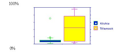
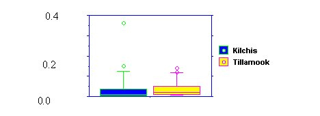
Figure 2. Large wood (m3/m2) in streams of the Kilchis and TIllamook sub-basins.
Benthic macroinvertebrate assemblages were structured by physical habitat factors related to both geology (stream width, volume of large wood, temperature, substrate composition) and land use (riparian zone canopy) (Mauger, et al., in preparation). Low order Tillamook streams bordered by pasture or timber harvest are characterized by taxa less well represented in Kilchis streams (e.g., oligochaete worms, and in riffles tanytarsid and orthoclad midges as well as species of Lepidostoma caddisflies and Zapada stoneflies). A baetid mayfly new to science and now believed to favor low-gradient streams of western Oregon was found in Tillamook but not in Kilchis streams.
Eleven fish species were encountered in this study, of which almost one-half were sculpin and all were native. This low species diversity is typical of Coast Range streams. Salmonids (primarily steelhead) dominated the Kilchis, while sculpins (primarily reticulate sculpin) dominated the Tillamook (see Figure 3). Low levels of hatchery supplementation may influence steelhead dominance in the Kilchis. Environmental variables (stream size, flow, substrate) were sufficient to predict the relative abundance of cutthroat trout and the major species of sculpin, but anadromous coho salmon and steelhead trout could not be predicted using physical habitat data (Rose, 2000; Rose and Ford, in preparation). We conclude that the relative abundance of these two species must be heavily influenced by other factors (e.g., biological factors, harvest pressure, access to spawning grounds, ocean conditions).
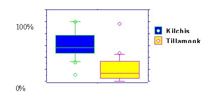
Figure 3. Percent salmonids in summer low-flow gish assemplages of streams
in the Kilchis and TIllamook sub-basins.
Scientific Information and Local Knowledge
Local people were generally not aware of scientific findings about ocean processes, water quality, and riparian habitat. Efforts to make local people aware of the scientific results and scientists aware of local knowledge were marginally successful. The difference in the views of scientists and local people revolve around many issues that impinge on decision making and the valuations that people make. One of the key problems is the relative priorities of ecological goals and property rights (Smith, et al., in press b). In addition, scientific results often do not match people's day-to-day experience. Further, resources to communicate scientific information are limited, and people do not trust scientific recommendations (Sweetwater, 2000; Smith, et al., in press b). To deal with these issues, we tried institutional mapping, qualitative risk assessment, PLACE mapping, and various outreach experiments. To evaluate the context and effectiveness of social institutions to change behaviors of local residents, we developed a technique called "institutional mapping" (Klingeman and Smith, 1998; Smith, submitted 2001). A qualitative institutional mapping analysis using expert opinion rankings indicated that water quality institutions under the Clean Water Act (CWA) have a slightly higher ability to improve watershed health than institutions associated with salmon restoration, forest management, or land use planning.
Landowners and businesses estimate the ecological risks associated with many activities (Smith, et al., submitted 2001). We call this "qualitative risk calculation" (QRC). Landowners often accept risks, such as siting structures and economic activities in hazardous areas, raising questions about their knowledge of potential risks. Landowners take risks in the face of ecological hazards because they perceive that the benefits outweigh the costs. Knowledge acquired in scientific research can help with QRCs, but science takes a more general, long-term, and ecosystem-oriented perspective. Further, scientific information filters down slowly to landowners and businesses, and it comes from a different perspective.
Outreach
A process to improve learning called PLACE (People Learning About Community and the Environment) mapping was tested. Monitoring the PLACE mapping process showed that this technique did facilitate learning about riparian issues in Tillamook County (Primozich, 2001). Partly based on the PLACE mapping work, the county is revising its riparian ordinance to conform with guidelines acceptable to the National Marine Fisheries Service, which has responsibility for actions on the Endangered Species Act.
The Tillamook County Performance Partnership Outreach Task Force was started by Susan Sweetwater in November 1999 (Sweetwater, 2000). The Task Force is still in operation and runs many events each year designed to educate local residents about scientific information that relates to issues being discussed in the community. These events include educational activities at festivals, fairs, the library, and art exhibits (Hadley, 2000; Scott, 2000; Sweetwater, 2000).
Efforts were made to monitor the effectiveness of outreach activities. This is very difficult, but the Outreach Task Force regularly asks monitoring questions about its activities. Due to the complexity of the situation, the number of different organizations attempting to affect actions in Tillamook County, and the fact that scientific information from this study was not available until the project ended, monitoring the actual affects of outreach is very difficult. We have some evaluations, but drawing causal links is very problematic.
Journal Articles on this Report : 7 Displayed | Download in RIS Format
| Other project views: | All 55 publications | 10 publications in selected types | All 8 journal articles |
|---|
| Type | Citation | ||
|---|---|---|---|
|
|
Colbert D, McManus J. Nutrient biogeochemistry in an upwelling-influenced estuary of the Pacific Northwest - Tillamook Bay, Oregon, USA. Estuaries 2003;26:1205-1219. |
R825751 (Final) |
not available |
|
|
Ford J, Rose CE. Characterizing small subbasins: A case study from coastal Oregon. Environmental Monitoring and Assessment 2000;64(1):359-377 |
R825751 (1999) R825751 (2000) R825751 (Final) |
not available |
|
|
Komar PD, McManus J, Styllas M. Sediment accumulation in Tillamook Bay, Oregon: Natural processes versus human impacts. Journal of Geology 2004;112(4):455-469 |
R825751 (Final) |
not available |
|
|
Naymik J, Pan Y, Ford J. Effects of basinwide logging on stream periphyton. Abstract Bulletin of the North American Benthological Society 2001;18(1):133-134. |
R825751 (Final) |
not available |
|
|
Scott LE, Ford J. Relationships between land use, geology, and in-stream phsyical habitat in small northern Oregon coastal streams. Ecological Society of America, 2001. |
R825751 (Final) |
not available |
|
|
Smith CL, Gilden J. Assets to move watershed councils from assessment to action. Journal of the American Water Resources Association 2002;38(3):653-662. |
R825751 (2000) R825751 (Final) R827146 (2000) R827146 (Final) |
Exit Exit |
|
|
Smith L, Ford J, Colbert D, Komar PD, McManus J. Coping with nature: acquiring knowledge, adopting technology, accepting risk. Environmental Management. |
R825751 (Final) |
not available |
Supplemental Keywords:
sediment processes, water quality, riparian habitat, local and scientific knowledge, ecosystem management, estuarine processes, land use impact, stream ecology, salmon., RFA, Scientific Discipline, Ecosystem Protection/Environmental Exposure & Risk, Geographic Area, Water, Waste, Ecological Indicators, Ecosystem Protection, Watersheds, Ecosystem/Assessment/Indicators, Contaminated Sediments, Geochemistry, Northwest, Social Science, Ecological Effects - Environmental Exposure & Risk, Water & Watershed, Ecology and Ecosystems, integrated assessment, integrated process study, ecological effects, ecological condition, ecosystem health, natural processes, contaminated sediment, water quality, bioassessment, watershed restoration, watershed assessment, Tillamook Bay, sediment transport, ecological exposure, ecological health, ecology assessment models, geology, land use, aquatic ecosystems, nutrient transport, anthropogenic processes, river ecosystemsProgress and Final Reports:
Original AbstractThe perspectives, information and conclusions conveyed in research project abstracts, progress reports, final reports, journal abstracts and journal publications convey the viewpoints of the principal investigator and may not represent the views and policies of ORD and EPA. Conclusions drawn by the principal investigators have not been reviewed by the Agency.