
Grantee Research Project Results
Final Report: Sustainable Coastal Habitat Restoration in the Pacific Northwest: Modeling and Managing the Effects, Feedbacks, and Risks Associated with Climate Change
EPA Grant Number: R833014Title: Sustainable Coastal Habitat Restoration in the Pacific Northwest: Modeling and Managing the Effects, Feedbacks, and Risks Associated with Climate Change
Investigators: Rybczyk, John , Reyes, Enrique , Hood, W. Greg , Khangaonkar, Tarang , Yang, Zhaoqing
Institution: Western Washington University , East Carolina University , Battelle Memorial Institute , Skagit System Cooperative
EPA Project Officer: Packard, Benjamin H
Project Period: April 1, 2007 through March 31, 2010 (Extended to March 31, 2012)
Project Amount: $879,247
RFA: Nonlinear Responses to Global Change in Linked Aquatic and Terrestrial Ecosystems and Effects of Multiple Factors on Terrestrial Ecosystems: A Joint Research Solicitation- EPA, DOE (2005) RFA Text | Recipients Lists
Research Category: Aquatic Ecosystems , Climate Change
Objective:
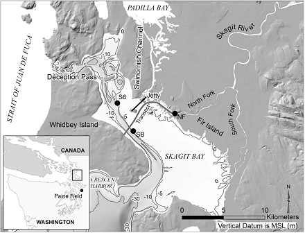
The Skagit River (Figure 1) is the largest in the Puget Sound estuarine system. It discharges about 39% of the total sediment load and can, at times, account for more than 50% of the freshwater flowing into Puget Sound. The Skagit River delta provides rich estuarine and freshwater habitats for salmon and many other fish and wildlife species. Over the past 150 years, development in the Skagit River delta has resulted in the significant loss of fish and wildlife habitat and alteration of habitat sustaining processes, particularly due to construction of dikes and levees. A Chinook Salmon recovery plan, developed by the Skagit River System Cooperative (a resource management and research cooperative among Skagit-basin Tribes that is participating in this research proposal through one of the principal investigators), has determined that at least 1,200 hectares of estuarine tidal marsh habitat should be restored in the Skagit delta to recover Skagit Chinook populations.
However, this estimate does not account for habitat loss that might result from a 20 to 100 cm sea level rise (SLR) over the next century. Several regional efforts to plan and implement Chinook recovery are underway, including Shared Strategy, the Salmon Recovery Funding Board, and the Puget Sound Nearshore Ecosystem Restoration Program. Yet none of these programs are currently addressing the implications of future sea level rise and other climate change impacts on estuarine rearing habitat for juvenile Chinook. Effective and sustainable estuarine habitat restoration must anticipate future environmental conditions to ensure that restoration efforts will be robust and capable of surviving anticipated climate change.
Coastal estuarine wetlands exist in a dynamic equilibrium in both the horizontal and vertical planes, between forces that lead to their establishment and maintenance, and forces that lead to deterioration. If coastal marshes are to survive rising sea levels, they must accrete at a rate such that surface elevation gain is sufficient to offset sea level rise. The potential for coastal wetland submergence has traditionally been determined by measuring and comparing rates of vertical accretion directly to rates of relative sea level rise (eustatic sea level rise plus subsidence), and then calculating an accretion deficit. However, these types of direct comparisons are prone to error because they do not account for possible nonlinear feedback mechanisms on the processes that contribute to surface elevation gain (i.e., sediment accretion and plant production). Specifically, changes in relative elevation can change allogenic sediment deposition, decomposition rates, and autogenic primary production, all of which in turn affect wetland elevation.
Figure 1. Skagit River estuary and Padilla Bay study area in Puget Sound, Washington
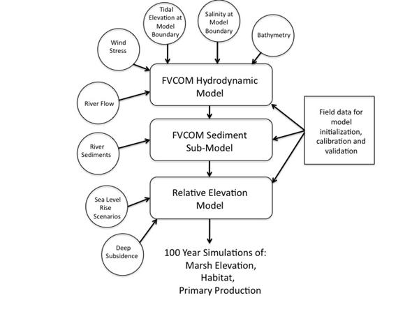
For these reasons, the overall objective of this proejct was to develop a predictive landscape simulation model, incorporating nonlinear feedbacks, of the ecological and geomorphological consequences of climate-induced sea level rise and river flow alteration of the Skagit River delta system (Skagit Bay and Padilla Bay). To accomplish this, we developed and linked a spatially explicit hydrodynamic and sediment transport model of the Skagit Delta system to a mechanistic wetland elevation dynamics and vegetation unit model (Figure 2). The linked models were initialized, calibrated and validated using extensive site-specific data sets that were collected as part of this project.
Figure 2. Flow diagram for the linked predictive landscape model for the Skagit River System. Circles represent model forcing functions, or drivers. Output includes changes marsh elevation, habitat and primary productivity over a 100-years period.
Summary/Accomplishments (Outputs/Outcomes):
(1) A hydrodynamic (FVCOM) and sediment transport model was developed for the Skagit Bay and Padilla Bay interconnected water bodies, including Swinomish Channel and portions of Saratoga Passage of Whidbey Basin (Figure 1). The hydrodynamic model successfully reproduced the hydrodynamic characteristics in the study domain, such as the diurnal inequality of tides, freshwater discharge plumes, and salinity intrusion at the river mouths. Overall, the model errors for tide are within 8% of the tidal ranges from MLLW to MHHW. Errors for velocity are mostly within 0.15 m/s. The signatures of neap-spring tidal cycle and diurnal inequality were observed in the collected data as well as model results. Errors for salinity are also in the acceptable range of 0.12 ~ 5.7 ppt. The model captured the interaction between surface freshwater plume and bottom salt water during the tidal cycle.
(2) The sediment transport model was our first attempt at simulating sediment deposition in the system using the FVCOM hydrodynamic solution for the combined Skagit Padilla Bay domain. Considerable improvement is needed to improve our ability to simulate movement and transport of sediments and the evolution of Skagit delta. This includes addition of processes such as bedload transport, multiple grain size, and geomorphological modeling to predict channel migration and bank erosion. The sediment transport modeling results therefore must be treated as preliminary and best viewed as sensitivity test results. Yet these preliminary results provide valuable insight into sediment transport properties in the Skagit River system.
The primary objective of the modeling component of this project was to provide information to a mechanistic wetland elevation dynamics and vegetation unit model, and models of tidal channel geomorphology and juvenile salmon abundance and distribution.
Specific conclusions are as follows.
- The majority of the suspended sediment load (97%) is transported out to the Skagit Bay.
- Most of the sediment appears to be transported out via the North Fork conduit, likely because North Fork carries a larger fraction of the total flow.
- Model simulations show that a very small fraction of Skagit River sediments are transported out to Padilla Bay. This is validated by the field data collected by WWU, which shows most of the stations in Padilla Bay indicate erosion.
(3) Confirming out modeling work, our network of elevation monitoring stations, monitored and enhanced as part of this study, has revealed that the eelgrass beds in the Padilla Bay National Estuarine Research Reserve are a net erosional system. The mean rate of surface elevation change throughout Padilla Bay was -0.22 ± 0.27 cm yrˉ¹ and values ranged from -0.80 cm yrˉ¹ to 0.22 cm yrˉ¹. Accounting for surface elevation change, eustatic SLR (0.33 cm yrˉ¹), and regional geologic uplift (0.09 cm yrˉ¹), we calculated a mean surface elevation deficit of -0.46 ± 0.27 cm yrˉ¹. These findings indicate that surface elevation change in Padilla Bay is not keeping pace with the current rate of SLR, and likely will not keep pace with predicted increases in the rate of SLR.
Output from the linked and spatialized Relative Elevation Model (Figure 2) indicates that bay-wide eelgrass productivity in Padilla Bay will increase under moderate SLR rise scenarios because, currently, bay-wide Z. Marina productivity is more limited by desiccation at its upper elevational limit rather than light attenuation at the lower limits.
Our simulations revealed that, compared to current conditions, bay-wide eelgrass net primary productivity would only decrease after a sea level rise of 1.8 meters.
Conclusions:
There were three major components to this project: (1) The collection and analyses of the field data required to initialize, calibrate and validate our models. As a stand alone, this work has utility in that, from the analyses of these kinds of data, we can begin to answer questions regarding estuarine response to sea level rise. For example, measurements of accretion, elevation change and sediment properties allowed us to directly compare rates of elevation change to current and predicted rates of sea level rise in Padilla Bay and Skagit Bay. (2) The development, initialization, calibration and validation of the FVCOM model (hydrodynamic and sediment) and REM model. (3) The linkage and spatialization of these models to predict the effects of sea level rise on estuarine habitat (and explore management options).
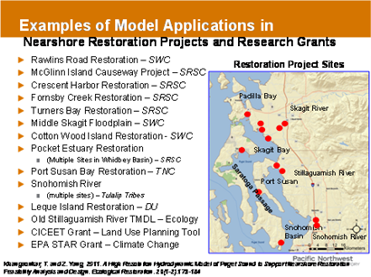
For any one project, the time, expense, and expertise required to complete all three phases of this project (starting at ground zero) are cost and time prohibitive. However, once the basic work is done (as we did here), it can be co-opted by others, as a whole or piecemeal. Here, we find the greatest utility. The FVCOM for Skagit Bay, developed as part, and because of this project, is now being used to guide the course of numerous restoration efforts in the greater Skagit Delta (Figure 3). Without initial funding from EPA, this tool would not be available. Similarly, the field work employed here has also been used to assist restoration managers measure the potential effects of sea level rise on estuarine systems, and to guide and monitor the efficacy of restoration efforts. For example, The Nature Conservancy is now using our field techniques (Sediment Elevation Tables) to monitor the effectiveness of restorations efforts in Port Susan Bay, WA. In summary, we have provided a suite of tools that researchers and restoration specialist can select from, to guide and inform their efforts.
Figure 3. Projects in the greater Skagit River delta that are currently using products (field methods and models) from this project to guide the course of their estuarine restoration efforts.
Journal Articles on this Report : 9 Displayed | Download in RIS Format
| Other project views: | All 30 publications | 10 publications in selected types | All 9 journal articles |
|---|
| Type | Citation | ||
|---|---|---|---|
|
|
Fagherazzi S, Kirwan ML, Mudd SM, Guntenspergen GR, Temmerman S, D'Alpaos A, van de Koppel J, Rybczyk JM, Reyes E, Craft C, Clough J. Numerical models of salt marsh evolution:ecological, geomorphic, and climatic factors. Reviews of Geophysics 2012;50(1):RG1002. |
R833014 (2010) R833014 (Final) |
Exit Exit Exit |
|
|
Hood WG. Beaver in tidal marshes:dam effects on low-tide channel pools and fish use of estuarine habitat. Wetlands 2012;32(3):401-410. |
R833014 (Final) |
Exit Exit |
|
|
Hood WG. Applying and testing a predictive vegetation model to management of the invasive cattail, Typha angustifolia L., in an oligohaline tidal marsh reveals priority effects caused by non-stationarity. Wetlands Ecology and Management 2013;21(4):229-242. |
R833014 (Final) |
Exit Exit |
|
|
Hood WG, Grossman EE, Veldhuisen C. Assessing tidal marsh vulnerability to sea-level rise in the Skagit Delta. Northwest Science 2016;90(1):79-93. |
R833014 (Final) |
Exit Exit |
|
|
Kairis PA, Rybczyk JM. Sea level rise and eelgrass (Zostera marina) production:a spatially explicit relative elevation model for Padilla Bay, WA. Ecological Modelling 2010;221(7):1005-1016. |
R833014 (2008) R833014 (2009) R833014 (Final) |
Exit Exit Exit |
|
|
Khangaonkar T, Yang Z, Kim T, Roberts M. Tidally averaged circulation in Puget Sound sub-basins: comparison of historical data, analytical model, and numerical model. Estuarine, Coastal and Shelf Science 2011;93(4):305-319. |
R833014 (Final) |
Exit Exit Exit |
|
|
Khangaonkar T, Yang Z. A high-resolution hydrodynamic model of Puget Sound to support nearshore restoration feasibility analysis and design. Ecological Restoration 2011;29(1-2):173-184. |
R833014 (2010) R833014 (Final) |
Exit Exit |
|
|
Yang Z, Khangaonkar T. Modeling tidal circulation and stratification in Skagit River estuary using an unstructured grid ocean model. Ocean Modelling 2009;28(1-3):34-49. |
R833014 (2008) R833014 (2009) R833014 (Final) |
Exit |
|
|
Yang Z, Wang T, Khangaonkar T, Breithaupt S. Integrated modeling of flood flows and tidal hydrodynamics over a coastal floodplain. Environmental Fluid Mechanics 2012;12(1):63-80. |
R833014 (2010) R833014 (Final) |
Exit |
Supplemental Keywords:
Accretion, climate change, estuaries, predictive modeling, Padilla Bay, Puget Sound, restoration, sea level rise, Skagit River, sediments, wetlands;Progress and Final Reports:
Original AbstractThe perspectives, information and conclusions conveyed in research project abstracts, progress reports, final reports, journal abstracts and journal publications convey the viewpoints of the principal investigator and may not represent the views and policies of ORD and EPA. Conclusions drawn by the principal investigators have not been reviewed by the Agency.