
Grantee Research Project Results
2007 Progress Report: Sustainable Coastal Habitat Restoration in the Pacific Northwest: Modeling and Managing the Effects, Feedbacks, and Risks Associated with Climate Change
EPA Grant Number: R833014Title: Sustainable Coastal Habitat Restoration in the Pacific Northwest: Modeling and Managing the Effects, Feedbacks, and Risks Associated with Climate Change
Investigators: Rybczyk, John , Hood, W. Greg , Reyes, Enrique , Khangaonkar, Tarang , Yang, Zhaoqing
Current Investigators: Rybczyk, John , Reyes, Enrique , Hood, W. Greg , Khangaonkar, Tarang , Yang, Zhaoqing
Institution: Western Washington University , Skagit System Cooperative , Battelle Memorial Institute , East Carolina University
Current Institution: Western Washington University , East Carolina University , Battelle Memorial Institute , Skagit System Cooperative
EPA Project Officer: Packard, Benjamin H
Project Period: April 1, 2007 through March 31, 2010 (Extended to March 31, 2012)
Project Period Covered by this Report: April 1, 2007 through March 31,2008
Project Amount: $879,247
RFA: Nonlinear Responses to Global Change in Linked Aquatic and Terrestrial Ecosystems and Effects of Multiple Factors on Terrestrial Ecosystems: A Joint Research Solicitation- EPA, DOE (2005) RFA Text | Recipients Lists
Research Category: Aquatic Ecosystems , Climate Change
Objective:
The overall objective of this proposal is to develop a predictive landscape simulation model, incorporating non-linear feedbacks, of the ecological and geomorphological consequences of climate-induced sea-level rise and river flow alteration in two of the most ecologically significant estuarine systems in Puget Sound, Padilla Bay and Skagit Bay. We will use the model to guide the course of restoration and management efforts, given climate change, as they relate to salmon habitat in Puget Sound.Progress Summary:
A. Field Activities for Model Initialization, Calibration, and Validation
1. Collected 982 soil porewater salinity samples at low tide throughout the estuarine emergent zone of the Skagit River tidal marshes. Sample spacing (resolution) was 160 m for a density of 1 sample per 2.5 ha. Some of these samples were also collected in the tidal scrub-shrub zone, but these were consistently freshwater areas so sampling generally focused in areas of greater salinity variation. Samples were collected at a range of river discharges, from 4,500 cfs to 30,000 cfs, with 128 points being sampled repeatedly at different river discharges. Mean annual river discharge is 16,000 cfs, and 4,500 cfs represents a record low flow for the Skagit River over the 68-years of records.
The object of this sampling was to understand the relationship between river flow and soil porewater salinity. We anticipate lower late-summer river flows in the future due to climate change impacts on snow pack in the Skagit watershed. Lower river flow should lead to higher soil salinity for longer periods of time with likely impacts on tidal marsh vegetation distribution, particularly tidal scrub-shrub communities.
Results indicated that soils were very responsive to seasonal variation in river flow. They also responded to patterns in river distributary geometry. Areas near deep river distributaries had lower salinities (0 – 5 psu). Areas away from distributaries had very high salinities (20 – 28 psu). Areas near distributaries that are being abandoned due to channel switching had intermediate salinities (8 – 13 psu).
These data will be used to initialize and calibrate the hydrodynamic model and validate predictions that will be generated by our Battelle collaborators (Tarang Khangaonkar and Zhaoqing Yang). They will also be able to be used to statistically model salinity distributions in a GIS environment.
2. Because tidal shrub habitat is likely to be highly vulnerable to increased salinity and sea-level rise, we investigated a suspected relationship between beaver activity and habitat type, with likely implications for juvenile salmon production.
We field-mapped the location of low-tide beaver dams, low-tide pools (25 – 150 cm deep), and low-tide shallows (<25 cm deep) in 25 km of tidal channels in the South Fork Skagit River tidal marshes, 13 km of channel in the tidal scrub-shrub zone and 12 km of channel in the tidal emergent zone. We also sampled low-tide pools and shallows in both zones for the presence of small fish, including juvenile salmon.
The results indicate that beaver dams are exclusively located in tidal scrub-shrub habitat, and that they quadruple the amount of low-tide pool habitat compared to tidal shrub and tidal emergent channels without beaver dams. Other features correlated with and likely forming low-tide pools were meander bends, large logs, and tributary junctions. 125 beaver dams were mapped, of which 117 were functional and the remaining in disrepair. This results in a density of 8.9 functional dams per kilometer of scrub-shrub tidal channel. In contrast, beaver dam frequency in fluvial systems are 0.14/km in eastern Oregon and 1.15/km coastal Oregon (Gurnell 1998. Progr. Phys. Geogr. 22:167-89), 2.6/km in coastal Oregon (Suzuki & McComb 1998. NW Science 72:102-110), 3/km in western Washington (MacCracken & Lebovitz 2005. NW Nat. 86:49-58), and 7.5-19.1/km in pristine North America (Pollock et al. 2003. Am. Fish. Soc. Symp. 37:213-233). Thus, Skagit estuarine shrub beaver dam densities compare with those in pristine fluvial systems. Similarly, 10 beaver lodges were found in the sampled areas for a density of 5.3/km2 of tidal shrub habitat, which is considerably greater than that in fluvial systems which range from 0.2-0.9/km2 in North America (Pollock et al. 2003 Am. Fish. Soc. Symp. 37:213-233). Evidently, tidal shrub habitat is very productive for beaver.
3. Fish sampling in pools and shallows in both habitat zones is not yet complete, but 28 channels have been sampled, 14 in each zone, on a pairwise basis (emergent vs. shrub) to statistically mask effects of river discharge variation and seasonality during the sampling period. Preliminary data analysis indicates that sticklebacks (Gasterosteus aculeatus), the most abundant fish in the system, are 4 to 5 times more abundant in pools than in shallows (per unit channel surface area), Chinook salmon are 5 to 8 times more abundant, chum salmon are more than 40 times more abundant, and coho salmon are 16 times more abundant. When the pool/shallows comparison is broken down by habitat type (tidal emergent vs tidal shrub), the differences between pools and shallows are several-fold greater for the emergent zone, but are only a factor of two for tidal shrub channels. The reason for reduced differences between pool and shallows in the shrub zone is that stickleback are 54 times more abundant in shrub vs. emergent shallows while Chinook are 5 times more abundant. This is likely due to the greater cover and protection from predators (mostly Great Blue Heron [GBH]) afforded by shrubs in the tidal shrub zone, and which leads to fish being less likely to seek shelter in deeper water. Ancillary mapping of GBH sightings and footprints indicated that GBH are exclusively foraging for fish in the tidal emergent zone. These results, taken with the increased pool frequency caused by beaver in the shrub zone, suggest that tidal shrub habitat provides significant low-tide habitat capacity for juvenile Chinook and sticklebacks, and likely provides significant refuge from predation. Loss of tidal shrub habitat due to climate change impacts would likely have signficant impacts to juvenile Chinook and other salmon—as well as other fish and wildlife.
B. Modeling
The existing model domain of Skagit Estuary developed by PNNL through previous projects was expanded to include Padilla Bay through the connection of Swinomish Channel to Skagit Bay. Similar to Skagit Bay, a large tide flat exists in Padilla Bay which is critical for providing nearhore fish habitat. To represent the tide flats accurately, we compiled historical data collected by NOAA by the National Ocean Service (NOS) and the historic U.S. Coast and Geodetic Survey (USCGS) (Figure 1). Additional bathymetric data in the Fidalgo Bay was provided by Padilla Bay National Estuarine Research Reserve (NERR). A navigation channel which appears to be a dredged extension of the Swinomish Channel exists in the shallow tide flats region in Padilla Bay and has been incorporated in the model geometry. The model grid was constructed with details to resolve such key feature as well as other main tidal channels in Padilla Bay.
Two open boundaries are specified in Padilla Bay. One is located at the mouth of Padilla Bay and the other is along the waterway between the Guemes Island and Fidalgo Island. Due to strong tidal currents in Skagit Bay and large freshwater flow from Skagit River, the Skagit River plume travels further south into Saratoga Passage, past the mouth of Skagit Bay where the existing Skagit Bay model open boundary is located. To accurately simulate the longitudinal dispersion of the Skagit River plume and to reduce the southern open boundary effect on interior computational domain, the southern open boundary was moved further down into Saratoga Passage in the south. The final model grid is shown in Figure 2.
There are no major rivers entering Padilla Bay except small stream runoffs from Joe Leary Slough and Indian Slough. The average annual flows for Joe Leary Slough and Indian Slough are 19.5 cfs and 8.2 cfs, respectively. These two sloughs are included as tributary inflows in the model.
A preliminary model run was conducted based on the model forcing for the period of June 2005, which corresponds to the calibration period for the existing Skagit Bay model. Model results showed that the Skagit Bay and Padilla Bay model reasonably re-produced the tidal dynamics and river plume dispersion observed in the Skagi Bay. Model results also indicated that freshwater inflows from Joe Leary Slough and Indian Slough, although small in magnitude, are important to salinity distribution in the shallow tide flats region of Padilla Bay. Figure 3 shows an example of model results over the study domain consisting of surface currents and salinity distributions.

Figure 1. Bathymetric data in Padilla Bay
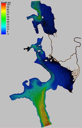
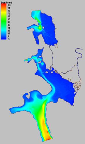
Figure 2. Model grid and water depth

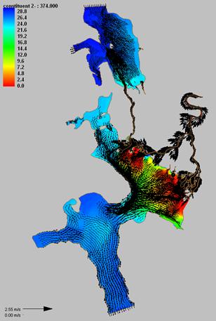
Figure 3. Simulated Surface Salinity and Velocity during Flood and Ebb Tides.
Journal Articles:
No journal articles submitted with this report: View all 30 publications for this projectProgress and Final Reports:
Original AbstractThe perspectives, information and conclusions conveyed in research project abstracts, progress reports, final reports, journal abstracts and journal publications convey the viewpoints of the principal investigator and may not represent the views and policies of ORD and EPA. Conclusions drawn by the principal investigators have not been reviewed by the Agency.