
Grantee Research Project Results
Final Report: US Freshwater Resources in the Coming Decades: An Integrated Climate-hydrologic Modeling Study
EPA Grant Number: R834190Title: US Freshwater Resources in the Coming Decades: An Integrated Climate-hydrologic Modeling Study
Investigators: Reinfelder, Ying Fan
Institution: Rutgers
EPA Project Officer: Packard, Benjamin H
Project Period: August 1, 2009 through July 31, 2012 (Extended to July 31, 2014)
Project Amount: $769,065
RFA: Consequences of Global Change for Water Quality (2008) RFA Text | Recipients Lists
Research Category: Aquatic Ecosystems , Ecological Indicators/Assessment/Restoration , Watersheds , Water , Climate Change
Objective:
This research was intended to quantify the potential changes in the hydrologic states (snow, soil moisture, groundwater level, river flow, wetland extent) and fluxes (precipitation, evapotranspiration, surface runoff, water table recharge, stream baseflow) across North America over the next decades (2008-2050).
Summary/Accomplishments (Outputs/Outcomes):
A. Groundwater is a strong modulator of large-scale land ecosystem dynamics, and through evapotranspiration (ET) the climate. Although the role of groundwater is well known at hillslope to watershed scales, its significance at continent to global scales is poorly understood, and hence large-scale land hydrology, ecosystem and climate models neglect groundwater dynamics. Through literature syntheses and model simulations, we highlighted field evidence and the global significance of the strong buffering effect of the slow-changing groundwater on seasonal river flow, flooding, soil moisture, wetland distribution and extent, and ET fluxes in North America (Pokhrel, et al., in preparation, 2-part series) and the dry-season Amazon ecosystems (Miguez-Macho and Fan, 2012a, 2012b; Pokhrel, et al., 2013, 2014) under present and future climate.
B. Global patterns of groundwater depth suggest that a large fraction of global land area is under the influence of groundwater. A data compilation of observed water table depth around the world from government archives and published literature revealed the drivers of water table depth at global, regional and local scales. Using a groundwater model, we filled in observation gaps to create a global map of mean water table depth at 1-km grid resolution (Figure 1) to identify where groundwater may be vital to land ecosystems. Patterns in water table depth explain patterns in wetlands at the global scale and vegetation gradients at regional and local scales. Overall, shallow groundwater influences 22 to 32% of global land area, including ~15% as groundwater-fed surface water features and 7 to 17% with the water table or its capillary fringe within plant rooting depths (Fan, et al., 2013). Using the model results, we also showed that lateral groundwater flow among river basins is a significant flux if the basins are smaller than 10 km on the sides (Krakauer, et al., 2014), which provides guidance to global climate models on the grid sizes where groundwater convergence matters to the water budgets.

C. Global water table depth will likely shift by the end of the century in response to the changing climate and sea level. Using the same global groundwater model, we projected the potential shifts in the water table depth, an indicator of groundwater-supported ecosystems, by the end of the century using the CMIP5 (latest IPCC, RCP85 scenario) projections of climate change. On one hand, the warmer climate will cause permafrost thawing and enhanced drainage in the boreal region, which will lead to a deeper water table. On another, changing rainfall and ET balance will alter groundwater recharge (Figure 2a, mean of 29 IPCC models). On the third, sea-level rise will restrict drainage in coastal regions causing the water table to rise (Figure 2b); the sea-level rise is corrected for the Glacial Isostatic Adjustment (GIA) whereby the continents are still rising in response to the removal of continental ice sheets of the last ice age (ended ~20K years ago); note an actual sea-level drop in the Hudson Bay area. Figure 3 shows the model simulated water table depth over 1981-2000 (Figure 3a), 2081-2100 (Figure 3b), and the changes (Figure 3c) over the North America continent (Li, et al., in preparation). It suggests that the water table will likely drop deeper (warm colors) in the boreal and Arctic region due to permafrost thawing (improved drainage) and a relative sea-level rise (due to GIA). It may be much deeper in the western states of the United States due to higher temperature and ET demand, and decreasing rainfall (reduced recharge). The same also may occur in some of the northeastern states. The rise in water table in Mexico may be an error due to slow model convergence in arid regions, and a repeat model run now is being conducted. Also a manuscript is being prepared (Li, et al., in preparation).


D. Large-scale irrigation over the High Plains is at least partially responsible for the observed changes in downwind, warm season precipitation, water table depth and streamflow. Analysis of observed precipitation changes in frequency and intensity over the period of 1895-2011 suggests that the expansion of cropland and irrigation in the High Plains is the likely cause of the observed changes in summer time precipitation in the downwind region. This study differs from other similar work in that we examined not only total precipitation change, but the separate contributions of changes in storm frequency from changes in storm intensity. Because climate warming is expected to increase storm intensity but reduce frequency, while landuse change is expected to cause increases in both frequency and intensity across the entire precipitation distribution, our work can improve our understanding of the causes of the widely observed precipitation change: climate change vs. landuse change (Alter, et al., accepted). A modeling study using WRF examines the mechanisms of irrigation-precipitation link by altering the thermal dynamics of the boundary layer, in addition to moisture addition to the atmosphere (Alter, et al., in preparation). Further analysis of downwind changes in groundwater level, soil moisture and stream flow suggests that the enhanced precipitation here due to irrigation upwind has clear hydrologic consequences; groundwater pumping for irrigation depletes groundwater and stream baseflow on the western side of the Mississippi, but enhances groundwater and river flow on the eastern side, making the drier western region even drier and the wetter eastern region even wetter (Kustu, et al., 2012). Figure 4c demonstrates this idea schematically, with Figure 4a showing the irrigation ramping up in the High Plains and Figure 4b groundwater level drop over the same period.

E. Developing a continental-scale, fully coupled terrestrial hydrologic model. One of the project goals is to integrate a dynamic groundwater module into our large-scale land model (LEAF, the land component of the regional climate model RAMS). As with all land models, LEAF does not have an explicit groundwater store, two-way groundwater-river exchange, flooding due to river over-bank flow and rising groundwater, and two-way soil and aquifer exchange. We added these processes to the original LEAF, developing an integrative, continental-scale hydrologic modeling framework called LEAF-Hydro-Flood (Figure 5) (Miguez-Macho and Fan, 2012a, 2012b). We believe that it is the only model that fully accounts for all terrestrial water stores and fluxes at continental scales. Key features are that (1) it is based on potential-driven flow formulation and fully diagnostic storages and fluxes, not empirical parameterizations, hence it requires few parameters and avoids parameter tuning; (2) it simulates backwater effects and the large flow inertia known to be important in large river systems such as the Amazon and Mississippi; and (3) it is computationally efficient. For the atmospheric part, we switched from RAMS to WRF, the NCAR community model. The coupled WRF-LEAF has been tested over Western Europe for precipitation recycling studies, and it is being tested in North America and the Amazon. Our integrated groundwater-surface model (LEAF-Hydro-Flood) now has been incorporated into WRF’s default land model, NOAH–MP (multi-physics) called “Miguez-Macho & Fan Water Table Dynamics”, and included in the standard release of the latest version of WRF, WRF3.6 (see http://www2.mmm.ucar.edu/wrf/users/workshops/WS2014/WorkshopPapers.php, 2014 WRF workshop presentation, pp. 12-16).

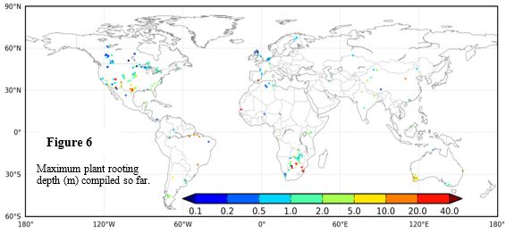
F. Our global data compilation and synthesis of plant rooting depths suggest that the depth to groundwater is a key driver; a deep water table can pull roots deeper if accessible to roots, and a shallow water table can push the roots shallower by causing water-logging and root anoxia. To understand where and when groundwater can influence land ecosystems, we need to know how deep down roots can penetrate. This motivated another global data compilation from published literature that not only reports climate, soil and vegetation conditions, but also data on the groundwater and drainage. It has so far yielded >1000 data points across the globe (Figure 6), and plotting them vs. rainfall and water table depth shows that the water table depth has much greater explanatory power than rainfall (Figure 7). A conceptual model has been constructed considering the dual water sources, rain from above and groundwater from below, in determining plant rooting patterns in different combinations of these drivers, and a numerical model is being developed to estimate global patterns of plant rooting depth as determined by satellite observed leaf area index (biotic drivers), observed atmospheric vapor deficit, and the soil water profiles influenced by rain and groundwater, and by soil physical properties (abiotic drivers). The model will be used to create a global map of rooting depth, which will vary from season to season (Fan, et al., in preparation; Fan, in preparation). Rooting depth data compilation will continue into the next few years, but the EPA grant has supported the basic scientific inquiries that motivated and initiated this comprehensive effort.

Journal Articles on this Report : 10 Displayed | Download in RIS Format
| Other project views: | All 13 publications | 10 publications in selected types | All 10 journal articles |
|---|
| Type | Citation | ||
|---|---|---|---|
|
|
Alter RE, Fan Y, Lintner BR, Weaver CP. Observational evidence that Great Plains irrigation has enhanced summer precipitation intensity and totals in the midwestern United States. Journal of Hydrometeorology 2015;16(4):1717-1735. |
R834190 (Final) |
Exit Exit Exit |
|
|
Fan Y, Li H, Miguez-Macho G. Global patterns of groundwater table depth. Science 2013;339(6122):940-943. |
R834190 (2013) R834190 (Final) |
Exit Exit Exit |
|
|
Fan Y. Groundwater in the Earth's critical zone: relevance to large-scale patterns and processes. Water Resources Research 2015;51(5):3052-3069. |
R834190 (Final) |
Exit Exit |
|
|
Fan Y, Miguez-Macho G, Jobbagy EG, Jackson RB, Otero-Casal C. Hydrologic regulation of plant rooting depth. Proceedings of the National Academy of Sciences of the United States of America 2017;114(40):10572-10577. |
R834190 (Final) |
Exit Exit |
|
|
Krakauer NY, Li H, Fan Y. Groundwater flow across spatial scales: importance for climate modeling. Environmental Research Letters 2014;9(3):034003 (7 pp.). |
R834190 (Final) |
Exit Exit Exit |
|
|
Kustu MD, Fan Y, Rodell M. Possible link between irrigation in the U.S. High Plains and increased summer streamflow in the Midwest. Water Resources Research 2011;47(3):W03522 (21 pp.). |
R834190 (2010) R834190 (2013) R834190 (Final) |
Exit Exit Exit |
|
|
Miguez-Macho G, Fan Y. The role of groundwater in the Amazon water cycle: 1. Influence on seasonal streamflow, flooding and wetlands. Journal of Geophysical Research:Atmospheres 2012;117(D15):D15113 (30 pp.). |
R834190 (2012) R834190 (2013) R834190 (Final) |
Exit Exit Exit |
|
|
Miguez-Macho G, Fan Y. The role of groundwater in the Amazon water cycle: 2. Influence on seasonal soil moisture and evapotranspiration. Journal of Geophysical Research:Atmospheres 2012;117(D15):D15114 (27 pp.). |
R834190 (2012) R834190 (2013) R834190 (Final) |
Exit Exit Exit |
|
|
Pokhrel YN, Fan Y, Miguez-Macho G, Yeh PJ-F, Han S-C. The role of groundwater in the Amazon water cycle:3. Influence on terrestrial water storage computations and comparison with GRACE. Journal of Geophysical Research:Atmospheres 2013;118(8):3233-3244. |
R834190 (2013) R834190 (Final) |
Exit Exit Exit |
|
|
Pokhrel YN, Fan Y, Miguez-Macho G. Potential hydrologic changes in the Amazon by the end of the 21st century and the groundwater buffer. Environmental Research Letters 2014;9(8):084004 (12 pp.). |
R834190 (Final) |
Exit Exit |
Supplemental Keywords:
water resources, global climate change, regional climate downscaling, water cycle modeling, air, hydrology, climate change, air pollution effects, environmental monitoring, RFA, Air, Scientific Discipline, Atmosphere, Air Pollution Effects, Hydrology, climate changeProgress and Final Reports:
Original AbstractThe perspectives, information and conclusions conveyed in research project abstracts, progress reports, final reports, journal abstracts and journal publications convey the viewpoints of the principal investigator and may not represent the views and policies of ORD and EPA. Conclusions drawn by the principal investigators have not been reviewed by the Agency.