
Grantee Research Project Results
2018 Progress Report: Prediction of Nonlinear Climate Variations Impacts on Eutrophication and Ecosystem Processes and Evaluation of Adaptation Measures in Urban and Urbanizing Watersheds
EPA Grant Number: R835866Title: Prediction of Nonlinear Climate Variations Impacts on Eutrophication and Ecosystem Processes and Evaluation of Adaptation Measures in Urban and Urbanizing Watersheds
Investigators: Barber, Michael , Clark, Brett , Goel, Ramesh , Hinners, Sarah , Burian, Steven
Current Investigators: Barber, Michael , Goel, Ramesh , Burian, Steven , Hinners, Sarah , Clark, Brett
Institution: University of Utah
EPA Project Officer: Packard, Benjamin H
Project Period: September 1, 2015 through August 31, 2018 (Extended to August 31, 2021)
Project Period Covered by this Report: September 1, 2017 through August 31,2018
Project Amount: $1,250,000
RFA: National Priorities: Systems-Based Strategies to Improve The Nation’s Ability to Plan And Respond to Water Scarcity and Drought Due to Climate Change (2014) RFA Text | Recipients Lists
Research Category: Water
Objective:
The Jordan River experiences many of the water quality concerns shared by urban streams throughout the western United States. The approved Total Maximum Daily Load (TMDL) of the river identified total dissolved solids, temperature, E Coli, and dissolved oxygen (DO) problems. While it is recognized that theses quantity and quality issues are related, holistic basin-wide solutions are missing. To meet U.S. EPA program goals, this project was specifically designed to investigate the direct and secondary interrelated impacts of climate change on surface water quality and availability in the Jordan River watershed for the protection of human and ecosystem health, and develop innovative, cost-effective management options that address these impacts. The following specific objectives will be addressed:
-
- Develop a dynamic water quantity/quality model of Jordan River watershed using Storm Water Management Model (SWMM), Distributed Hydrology Soil Vegetation Model (DHSVM), Environmental Fluid Dynamics Code (EFDC), and Water Quality Analysis Simulation Program (WASP)
- Link the process-based model of the Jordan River watershed to a system dynamics model of the integrated urban water system for the Salt Lake City metropolitan area
- Integrate each of the four Fifth Climate Assessment Report (AR5) climate projections into prediction of 2050 water quantity and quality baseline scenarios
- Conduct field and laboratory analysis to parameterize kinetic coefficients and determine non-linear responses under climate scenarios
- Examine land use planning implications including scale-related phenomenon related to headwater versus downstream economic, social, and ecosystem constraints
- Hold participatory stakeholder workshops to develop future scenarios related to conservation, reuse, land use changes due to population, Best Management Practice (BMP)/ Low Impact Development (LID) implementation, wildfire disturbances, and water management
- Use models to examine impacts of scenarios and levels of investments needed to achieve a sustainable environment for economic and ecosystem protection
- Create a framework for maximizing value of BMP placement through off-site investment to achieve water quantity and quality goals
- Incorporate findings into classroom instruction that help prepare the future workforce in thinking holistically to solve tomorrow's challenges.
The expected outcomes of this project include: a) a dynamic tool capable of accurately predicting the appropriate numeric nutrient criteria for the Jordan River and Utah Lake necessary to prevent eutrophication under existing and future climate conditions; b) an integrated process-systems model capable of coupling detailed watershed-water quality dynamics (the process model) with planning, policy, people, and interconnected systems such as water supply and water demand (the systems model); c) peer-reviewed journal papers in engineering, ecology, planning, and sociology related venues; d) public workshops to Jordan River stakeholders and other public outreach activities such as community seminars and K-12 education; and e) revised curriculum contents integrating interdisciplinary research approaches and findings into case studies designed to expand the envelope of creative thinking.
We will continue to work closely with stakeholders across a broad spectrum to develop a comprehensive management tool that can evaluate water management strategies for the entire Jordan River watershed. Implementation of this comprehensive approach will guarantee scientifically defensible solutions that incorporate social and ecosystem needs and lead to a sustainable future. Additionally, our modeling framework will be used to demonstrate locally that comprehensive regional solutions will be more beneficial than solutions that pit upstream and downstream communities against each other or that divide the stakeholder groups along narrow boundaries of special interest. It will illustrate how innovative community planning facilitates environmentally sustainable change.
Progress Summary:
Summary of Work Towards Completion of the Nine Objectives
Several of the primary project objectives are to create a process-based modeling framework by developing a dynamic water quantity/quality model of Jordan River watershed using SWMM, DHSVM, EFDC, and WASP and linking the process-based model of the Jordan River watershed to a system dynamics model of the integrated urban water system for the Salt Lake City metropolitan area. Initial tasks for model development are in progress, include data accumulation from a number of agencies, facilities, and researchers as well as review of scientific literature. As part of this accumulation, data that have been obtained have begun the quality control and formatting process, and are currently being organized within file databases and GIS databases. This process of data review has aided in identifying additional data needs (such as higher frequency measurements of water quality data near wastewater outflows), and the appropriate agencies have been contacted in order to obtain these data.
Process-based Modeling Progress
The water quality and quantity models for both the Jordan River and Utah Lake are being developed for the extended simulation periods planned for the project. Sensitivity analyses have been conducted upon the August 2009 Jordan River steady-state WASP models for assessing the effects of different input parameters upon the performance of the models. Calibration and sensitivity analyses are being conducted for the dynamic model (Water Year 2009). For the historical models over the Jordan River (steady-state and dynamic models), the topography and canopy shading appears to exhibit significant effects upon water temperature and dissolved oxygen. Therefore, tentative changes upon the land use and vegetation characteristics under the future simulations of the Jordan River WASP may require the development of a distinct riparian vegetation layer over the Jordan River. Consequently, collaborations are currently occurring among members involved in the riparian vegetation planning over the Jordan River involving the Salt Lake City Trails and Open Lands and the Jordan River Commissions for determining potential changes planned over the vegetation and land use characteristics.
Due to the need for simulating the hydrodynamics of Utah Lake, a separate WASP water quality model is being development and linked to the hydrodynamic model developed using Environmental Fluid Dynamics Code (Visual EFDC) provided by Tetra Tech, Inc. Testing is currently being conducted upon the hydrodynamic linkage from the Utah Lake EFDC Model. EFDC has been obtained and run for a historic 2005 base case of Utah Lake. The preliminary grid system is based on a Cartesian grid, 500-m square cells, 1,694 horizontal grid cells, 5 vertical layers for a total of 8,470 output cubes. An EFDC model is being built for the historic period water year (WY) 2000-2009. The model will serve as the baseline condition for comparison of future scenarios. A Sampling and Analysis Plan for data collection to support EFDC development and calibration has been completed. Funds were secured for the requisition of an Acoustic Doppler Velocimeter (ADV) by the Utah Division of Water Quality (UDWQ). A Memorandum of Understanding (MOU) was developed between UDWQ and EPA Office of Research and Development (ORD) to loan an Acoustic Doppler Current Profiler (ADCP). Deployment of instrumentation and collection of velocity, wave height, water quality constituents, and sediment characterization data is anticipated for spring and summer 2019.
The Distributed Hydrology Soil Vegetation Model (DHSVM), a physically based distributed modeling system developed for mountainous forested watersheds, represents the physical processes that control runoff generation. DHSVM is being applied to simulate streamflows in high spatial and temporal resolutions for 12 different non-urban watersheds in the Jordan River and Utah Lake drainage areas for the historic period water year (WY) 1998-2004. Data collection, cleaning and processing were completed to run the DHSVM models for the Jordan River and Utah Lake watersheds. Sensitivity analyses of the models have also been performed to understand which parameters are more sensitive for the models. As DHSVM deals with lots of soil, vegetation and hydrologic parameters so understanding the sensitivity of the models to different parameter is important for proper calibration of the models. The model will be used to predict changes in water quantity and quality (stream temperature) in 2050 under different climate change scenarios by integrating AR5.
The U.S. Environmental Protection Agency's Storm Water Management Model (SWMM) model is being used to estimate quantity and quality of urban stormwater runoff discharges into Utah Lake and the Jordan River. Urbanized areas of the watershed making significant contributions to stormwater runoff are being represented in the model. The primary objective of the stormwater model is to determine the impact of climate change, urbanization and land use on stormwater runoff from urban areas in Jordan River and Utah Lake watersheds such that receiving water models can assess the implications for water quality. A second objective is to assess the effect of implementation of Green Infrastructure (GI) strategies to manage the stormwater quantity and quality from the site to the regional level.
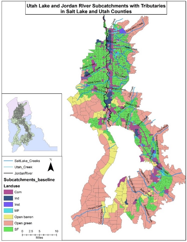
For model development, the catchment areas in both Utah Lake and Jordan River watersheds were delineated based on land uses using ArcGIS, as shown in Figure 1. For this model, 2,460 subcatchments ranging in size from 0.25 acres to 1,000 acres (average 250 acres) were delineated contributing to ten outfalls to Utah Lake and 20 outfalls to Jordan River. The percentage imperviousness, curve number, and slope are input parameters for SWMM model. The values of percentage imperviousness were calculated using National Oceanic and Atmospheric Administration (NOAA) Interactive Stratified Attribute Tracking (ISAT) tool. The percentage imperviousness value range from 12 for open green/pastures and maximum of 85 for commercial/downtown areas. The Soil Conservation Service (SCS) curve number grid gives the curve number using soil and land use data in each sub-catchment polygon. After incorporating the values of input parameters in ArcGIS, the model was exported to SWMM for simulation.
A baseline SWMM model is being developed for historic period from 2001 to 2009. The baseline model will be driven using the RCP 6.0 dynamically downscaled climate data. The baseline model will be a reference point for comparison with land-use change, urbanization and climate change future scenarios.
Figure1. Delineated subcatchments of Utah Lake and Jordan River watersheds based on land use.
Model Integration Simulations
For this exercise, several simulations are planned for simulating historical and future water quantity and quality characteristics for both the Jordan River and Utah Lake systems. Each simulation involves interaction between the different models, with selected outputs from one model serving as inputs for a downstream model. The following figure displays such relationships among the different models (DHSVM, SWMM, GoldSim, EFDC, and WASP), which are all subject to land use/development scenarios and climate change projections.
In this exercise, such model integrations are applied over a historical period (2000-2009) followed by a future period (2035-2044). These periods were selected due to match available climate data and population/development/land use scenarios produced by the Gardner Policy Institute and the REMM development model. Table 1 provides a general description of the selected time period, development scenarios, and climate change projections used in the historical baseline and future simulations. As indicated in the following table, the exact number of runs expected under the future simulations is still being determined, depending on feedback from stakeholders.
Figure 2 . Model Integration Workflow for Historical Baseline and Future Simulations.
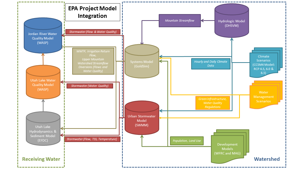
Table 1 . Comparison of Time Periods, Land Use Scenarios, and Climate Projections between the Historical Baseline and Future Simulations.
Category | Historical Baseline | Future |
Time Period | October 1, 2000 to September 30, 2009 | October 1, 2035 to September 30, 2044 |
Number of Land Use Scenarios | 1 | 2 (exact number of scenarios TBD) |
Land Use Scenario- Year | 2005 | 2040 |
Land Use Scenario(s) | Historical | “Business-as-Usual”, “Preferred” |
Climate Change Projections | RCP 6.0, RCP 8.5 | RCP 4.5, RCP 6.0, RCP 8.5 |
Number of Runs Total | 2 | 6 (exact number of runs TBD) |
Modeled climate data are employed for the historical and
futuristic simulations to analyze the effects of climate change that
are defined by the Representative Concentration Pathways (RCPs) on
water quantity and quality. The following data sources are implemented
for defining the modeled climate data for the historical baseline and
futuristic simulations.
- RCP 6.0: Dynamically-Downscaled (6-km) Hourly Climate Data by Dr. Court Strong from the Department of Atmospheric Sciences at the University of Utah
- RCP 4.5 and RCP 8.5: Multivariate Adaptive Constructed Analogs (MACA) Statistically-Downscaled (4-km) Daily Climate Data from Dr. John Abatzoglou from the University of Idaho
Comparison of precipitation and temperature between the two historical MACA datasets indicates very little difference over the baseline period (2000-2009), so the RCP 8.5 is selected for the historical baseline that corresponds with both the RCP 4.5 and RCP 8.5 statistically downscaled future scenarios. However, there are notable differences between the dynamically downscaled and statistically downscaled historical climate data. Work is proceeding to understand the impacts of the two data sources.
Field and Laboratory Measurements of Kinetic Coefficients
This past summer (2018), we sampled seven sites across the Utah Lake at six different times at a monthly basis from early May to late September. At selected sites, depth integrated water samples were also collected. Table 2 details the list of parameters measured and methods we used.
Table 2. Parameters and methods.
Parameters | Methods |
Water and sediment collection | Depth water sampler and sediment dredge |
Temp, pH, TDS, DO, conductivity | YSI sampling probe and DO probe |
Ammonia-N, TP, TN | Hach kit |
Nitrite-N, nitrate-N, ortho-P | IC anion detect |
Chlorophyll a | EPA method 445.0 |
cBOD | BOD5 standard method |
Metal elements | ICP -MS for 20 primary metal elements |
Cyanotoxins | Microcystins and nodularin were measured using LC-MS follow EPA method 544.0 |
DNA extraction and microbial analysis | Qiagen PowerWater Kit and amplicon sequencing |
RNA extraction and gene expression analysis | PureLink RNA Mini Kit and reverse transcript for RNA quantification using PCR |
Sediment analysis | Planned for mineralogy, phosphorus sorption/release analysis and surface microbial community analysis |
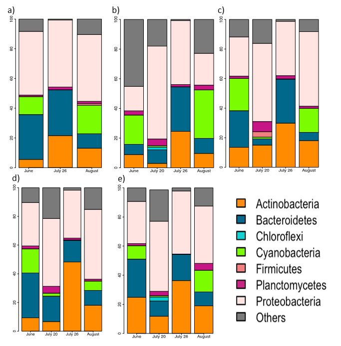
Visible algal blooms were recorded in Provo Bay towards the end of June, 2018 and persisted until late August. With the passage of time into late summer and early fall, Harmful Algal Blooms (HABs) spread from Provo Bay to other parts of the Lake. Our sampling efforts captured this event. Using genomic DNA extraction, we continued examining cyanobacteria speciation in Utah Lake. DNA was extracted from surface water samples using PowerWater DNA isolation kits and then genomic DNA samples were amplified targeting the V4 region 16S rRNA universal bacterial/archaea region. A total of 36 species were detected in the 2017 samples with the dominant cyanobacteria species being synechococcus and aphanizomenon. Not all cyanobacteria are toxin producing. The main toxin-producer was microcystis. Figure 3 illustrates the relative abundancies for bacteria (phylum level) of sampled sites at these five Utah Lake sampling locations: a) Pelican Point, b) Provo Bay, c) Geneva Discharge, d) Lincoln Beach, and e) Saratoga Springs.
Figure 3 . Utah Lake cyanobacteria.
We have sampled surface sediment with temporal and spatial resolutions using a sediment dredge. We are planning for experiments like mineralogy analysis (Raman spectrometry and XRD), lab scale phosphorus release and adsorption analysis, and microbial community analysis. The analysis of sediment parameters will be decided based on recommendation made by Utah Lake Science panel set forth by the Utah Division of Water Quality.
Examination of Land Use Planning Decisions
As reported last year, we are responsible for producing current and projected land use maps for the urbanized and urbanizing areas of the watershed in a format that translates to the SWMM portion of the model. At that time, we had generated 200 m x 200 m grid cell maps of current land use and the business-as-usual scenario projections to 2049. In late spring of 2018, our Metropolitan Planning Organization, the Wasatch Front Regional Council, had completed their current modeling process and generated a "preferred scenario". This means that through coordination and agreement with all of the planning bodies in the five county region (municipalities, counties, and state-level agencies), an alternative to the business-as-usual scenario was adopted as the guide for land use and transportation planning activities. Wasatch Front Regional Council (WFRC's) scenario model, called REMM (the Real Estate Market Model), produces spatial model predictions that they have shared with us to form the basis of an alternative land use scenario. We have been working with these data to produce a useable data input to our water quality model, so that the business-as-usual model may be compared with the preferred scenario. More specifically, planning in our region attempts to rein in spatial growth and expensive transportation infrastructure projects by concentrating growth in "centers." The efficacy of this strategy with regard to water quality is a question we will be able to test.
Development of Future Scenarios via Public Involvement
Looking ahead to the task of working with stakeholders to develop and explore scenarios once the models are ready to present, our team has been studying the water quality-related stakeholder "landscape" in the Jordan River watershed. We are examining issues related to the decision-making processes from a framework that considers three basic elements of the system: knowledge (what do we know/not know about the system?); options (what management options, or "levers" are available within ecological, political, and economic constraints?); and connections (relationships among the stakeholders and within broader networks). By exploring these dimensions of the social-ecological system of the watershed, we can identify and tailor key questions that our model will need to address. In 2017, the Utah Department of Water Quality launched a stakeholder engagement process to oversee water quality modeling and standard development for Utah Lake and to facilitate buy-in on the scientific research and decision-making. We have attended meetings of both the Steering Committee and the Science Panel and we will be analyzing notes and transcripts of these meetings to gain insight into our questions about knowledge, options, and connections.
In the Jordan River valley, in the spring and summer of 2018, we undertook a situation assessment that consisted of interviews with members of the Technical Advisory Committee as well as other stakeholders suggested as important individuals concerned and/or knowledgeable about water quality issues associated with the Jordan River by our interviewees. We completed 31 interviews ranging in length from 30 minutes to over 3.5 hours. The interviews were transcribed during the summer and fall 2018. We are currently analyzing those interviews.
Future Activities:
Initial results of the systems model show a clear increase in future discharge volume to the river and lake at these specific points, as well as how newer facilities and operations change the distribution of wastewater discharge. While some of these locations will still be smaller systems compared to the larger areas in the Jordan River Valley, the relative increase to the discharge and loading will likely be a major contributing factor to differences in simulations of future water quality. These initial comparisons illuminate several important research questions which will be explored via multi-scenario modeling activities and by integrating results of the hydrologic and stormwater models. The public is extremely interested in this work and continues to be engaged in the process via our collaborations with EPA and the Utah DWQ. The following tasks are planned for the upcoming year to provide additional information to advance the project objectives:
- Complete the WASP sensitivity analysis on all Jordan River segments and determine the top parameters that appear to exhibit the "most significant" impact upon the results for the water quality constituents.
- Develop example scenarios for the Utah Lake model with EFDC hydrodynamic linkage and evaluate the results for different water quality constituents.
- Implement the calibrated Jordan River models toward the dynamic simulations based on the scenarios which incorporate results from different models (e.g., GoldSim, SWMM, EFDC) and requires different climate, land use, and population scenarios.
- Continued development of statistically downscaled data from daily to hourly scale to use as input to the developed DHSVM models and further
- EFDC activities will include updating the 2005 model to 2015-16 conditions, completion of sensitivity analysis, and creation of scenarios based on climate conditions.
- SWMM activities involve incorporating various BMP scenarios into prediction of urban runoff loads to WASP model based on land development projections.
- Determine the appropriate land-use characteristics for future scenarios, updating the irrigation and indoor/outdoor demands to reflect these future land-use characteristics.
- Adding a stochastic representation of loading from waste water treatment facilities.
- Conduct high throughput amplicon sequencing as a routine monitoring tools on genomic DNA.
- Conduct additional laboratory and field sampling work related to the parameters defined by the modeling needs.
- Continue to analyze survey of public understanding and attitudes toward development of a sustainable future.
References:
Li H, Alsanea A, Barber M, Goel R. High-throughput DNA sequencing reveals the dominance of pico- and other filamentous cyanobacteria in an urban freshwater Lake. Science of the Total Environment 2018;661:465-480.
Journal Articles on this Report : 1 Displayed | Download in RIS Format
| Other project views: | All 27 publications | 11 publications in selected types | All 10 journal articles |
|---|
| Type | Citation | ||
|---|---|---|---|
|
|
Li H, Alsanea A, Barber M, Goel R. High-throughput DNA sequencing reveals the dominance of pico-and other filamentous cyanobacteria in an urban freshwater Lake. Science of the Total Environment 2018;611:465-480. |
R835866 (2018) R835866 (2019) R835866 (2020) |
Exit Exit Exit |
Supplemental Keywords:
Nutrients, sediment oxygen demand, integrated assessment, conservation, reuse, socio-economic, public policyProgress and Final Reports:
Original AbstractThe perspectives, information and conclusions conveyed in research project abstracts, progress reports, final reports, journal abstracts and journal publications convey the viewpoints of the principal investigator and may not represent the views and policies of ORD and EPA. Conclusions drawn by the principal investigators have not been reviewed by the Agency.