


Step 2: Characterize Your Watershed (cont.)
Using Monitoring Data or Literature Values to Estimate Pollutant Loads
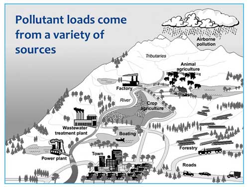
Commonly used approaches for estimating pollutant loads in watersheds involve using in-stream monitoring data or literature values (e.g., land use loading rates). These simple approaches can vary in detail or scope depending on the needs of the analysis and the available data. In most cases, they provide a coarse estimate of the pollutant loads entering a water body, without great detail on the contributing sources or areas of concern.
Monitoring data can be used to directly estimate the pollutant loading entering a water body. Because the monitoring data represent in-stream conditions, the resulting estimate represents the total loading from a watershed upstream of the monitoring point. This type of estimate does not attribute loads to particular sources or areas. This generalized loading can help to evaluate downstream impacts, can be used to calculate a per acre loading, and can be used for comparing local loadings with those of other areas. This loading estimate is also based on historical conditions because it is directly estimated from monitoring data. It cannot be used to directly predict how loadings might change in the future.
Empirical relationships documented in scientific literature are another option for estimating pollutant loads. Empirical relationships are those based on observed data, and they are represented by an empirical equation. An example of an empirical relationship relating watershed characteristics to pollutant loading is the Simple Method (Schueler, T. 1987. Controlling urban runoff: a practical manual for planning and designing urban BMPs. Metropolitan Washington Council of Governments. Washington, DC). The Simple Method is a lumped-parameter empirical model used to estimate stormwater pollutant loadings under conditions of limited data availability. Because it is a lumped approach, it assumes the physical characteristics for land units within a subwatershed are homogeneous, thereby simplifying the physical representation of the subwatershed. The approach calculates pollutant loading using drainage area, pollutant concentrations, a runoff coefficient and precipitation data. In the Simple Method, the amount of rainfall runoff is assumed to be a function of the imperviousness of the contributing drainage area. More densely developed areas have more impervious surfaces, such as rooftops and pavement, causing more stormwater to run off rather than being absorbed into the soil. The Simple Method includes default and suggested values for the equation parameters, or values can be watershed-specific based on monitoring data or local information.
EPA provides various technical guidance documents on their TMDL Technical Support Documents webpage. These resources range from short fact sheets to detailed handbooks, including the Draft Handbook for Developing Watershed TMDLs (PDF) (168 pp., 3.6 MB, about PDF files). The materials are designed to help watershed planners identify and address specific impairments and discuss the potential environmental, financial, and implementation benefits of developing TMDLs on a watershed scale. This Draft Handbook provides practitioners with a series of screening factors that should help determine, based on pollutant type, water body type, data quality, and other considerations, the site specific suitability of the TMDL watershed approach. Additionally, the Draft Handbook highlights the connections between watershed TMDLs and other water programs, identifying opportunities for integrating watershed TMDLs into other similar water quality management efforts, such as watershed planning, permitting, and water quality trading.