Entrenchment
The term "entrenchment ratio," which is the vertical containment of the river, has been quantitatively defined (Rosgen 1994) to provide a consistent method for field determination. The entrenchment ratio is the ratio of the width of the flood-prone area to the surface width of the bankfull channel. The flood-prone area width is measured at the elevation that corresponds to twice the maximum depth of the bankfull channel as taken from the established bankfull stage.
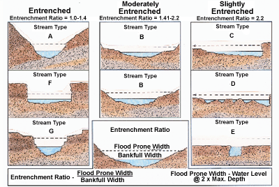
The accompanying figure shows representative entrenchment ratios from cross-sections of various stream types. The degree of entrenchment described by these ratios is based on empirically derived relationships between flood-prone areas and bankfull channel cross-sections, developed from hundreds of stream channel measurements representing a majority of the described stream types. Ratios of 1-1.4 represent entrenched streams; 1.41-2.2 represent moderately entrenched streams; and ratios greater than 2.2 indicate rivers only slightly entrenched in a well-developed floodplain.
Several steps are needed to determine entrenchment. To measure the width of the flood prone area, select the elevation that corresponds to twice the maximum bankfull channel depth as determined by the vertical distance between bankfull stage and the thalweg of a riffle. Field observations show that for most stream types, this elevation is associated with a < 50 year return period flood, rather than with a very rare flood. The entrenchment ratio is based in part on dimensionless rating curves that plot mean depth to bankfull depth (d/dbkf) against the corresponding discharge ratios (Q/Qbkf) (Dunne and Leopold 1978).
The 50-year recurrence interval flood discharge yields a dfpa/dbkf ratio of between 1.3 to 2.7 across all stream types, with an average ratio value of 2.0. Obviously, this value is also a function of the total width of the flood prone area available to the river. Field verification of hundreds of cross-sections, is the basis for using the value of 2 times the maximum depth at the bankfull stage to estimate the elevation and extent flood-prone area in the field. The average ratio value selected is 2.0 rather than the stratified Level II ratios of 1.3 to 2.7. When mean values were used rather than maximum values, the low terrace elevations in the C stream types would not have been included in the flood-prone area, contrary indicators from the gage data/flood stage data. Based on these observations, twice maximum bankfull depth was selected as an index, to represent an estimate of the representative flood prone area elevations.
For stream types that are only slightly entrenched (e.g., stream types "C," "D," "DA," and "E"), flows greater than the bankfull stage overtop their streambanks and extend onto their floodplain. This natural phenomena does not hold true for deeply entrenched channels (e.g., stream types "A," "F," and "G") where the actual top-of-bank elevations are much higher than the bankfull stage. For entrenched channels, streamflows greater than bankfull increase in depth much faster than in width, as discharge increases. In entrenched channels, the "flood-prone" area increases only marginally in width with an increasing flow-stage above bankfull elevations. The distribution of shear stress (a product of the specific weight of water, hydraulic mean depth and channel slope) and of very high velocity gradients (high boundary stress) on both high banks of an entrenched channel during floods is partly responsible for the associated high bank erosion rates observed in the "A," "F," and "G" stream types.