Gathering Field Data for Level II
The Reference Reach
The morphological variables used to define stream types at Level II can and do change within short distances along a river channel, due to changes in geology and tributary influence. A Level II classification may apply to a reach that is only a few tens of meters in length, or to a reach distance of several kilometers. It is important to note that data from individual channel reaches are not averaged over entire basins. Extrapolations necessary to describe the variety of stream types that may exist within a broad area are instead based upon Level II field measurements taken from selected "reference" reaches. Interpretations developed on the basis of data and analysis related to the reference reach can then be extrapolated to other similar reaches, where such detailed data is not readily available.
The use of a reference reach concept enables Level II stream type classifications to be completed for other similar areas without requiring extensive on-site data collection. It is essential, however, to
- calibrate the bankfull channel dimensions at gaging stations for representative stream types within the particular hydro-physiographic regime;
- use aerial photography and topographic maps for preliminary identification of stream types; and
- measure and analyze representative or reference reaches to verify the initial interpretive classifications.
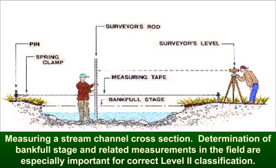
Bankfull discharge
The stage or elevation of bankfull discharge is the single most important parameter used in Level II classifications. The stage of bankfull discharge is related to channel dimensions such as width, and channel patterns such as meander length, radius of curvature, belt width, meander width ratio and amplitude. Moreover, the bankfull channel width is required to estimate two of the five primary Level II criteria (i.e., entrenchment ratio and width/depth ratio).
Field Determination of Bankfull Stage. The most consistent bankfull stage determination is obtained from identification of the top of the floodplain. This elevation is where incipient flooding begins for those flows that extend above the bankfull stage. Many floodplains are constructed as the river moves laterally, away from established point bars. The elevation of the top of point bars and the bankfull stage thus share a common elevation that is directly related to the development of floodplains within the valley, given the current climate regime. It is important for the field observer to recognize the physical and morphological difference between a low terrace and floodplain, since alluvial channels with well developed floodplains can often have low elevation river terraces (abandoned former floodplains) adjacent to the channel. For those stream types that exhibit a well-developed floodplain, - such as the "C," "D," "DA," and "E" types - the bankfull stage is easily and reliably identified as the elevation of the floodplain.
Where floodplains are not well developed, the identification of bankfull stage must be determined by field stage indicators that may be combined as corroborating evidence for an indication of a consistent and common elevation. The appropriate use of any or all of the bankfull stage indicators requires adherence to four basic principles:
- Seek indicators in the locations appropriate for specific stream types.
- Know the recent flood and/or drought history of the area to avoid being mislead by spurious indicators (e.g., colonization of riparian species within the bankfull channel during drought, or flood debris accumulations caught in willows that have rebounded after flood flows have receded).
- Use multiple-indicators wherever possible for reinforcement of a common stage or elevation.
- Where possible, calibrate field determined bankfull stage elevations and corresponding bankfull channel dimensions to known recurrence interval discharges at gaged stations. This procedure can verify the difference between the floodplain of the river and a low terrace.
There are several visual or physical indicators of the bankfull stage that enable field determination of this important parameter for areas where streamflow records are not available. The bankfull stage indicators vary in their importance and discriminating power for different stream types. A partial listing of these indicators follows:
- The presence of a floodplain at the elevation of incipient flooding.
- The elevation associated with the top of the highest depositional features (e.g., point bars, central bars within the active channel). These depositional features are especially good stage indicators for channels in the presence of terraces or adjacent colluvial slopes.
- A break in slope of the banks and/or a change in the particle size distribution, (since finer material is associated with deposition by overflow, rather than deposition of coarser material within the active channel).
- Evidence of an inundation feature such as small benches.
- Staining of rocks.
- Exposed root hairs below an intact soil layer indicating exposure to erosive flow.
- Lichens and - for some stream types and locales - certain riparian vegetation species
Calibrating Bankfull Stage to Known Streamflows. A common error in the Level II classification process is the failure of field observers to calibrate the elevations of appropriate field indicators of bankfull stage to known streamflows. Such calibration is essential until one gains sufficient field experience in a given locale to be sure of the proper interpretation of those indicator features representing the stage or elevation of the bankfull discharge. The recommended procedure for calibrating field identified bankfull stage with known streamflows and return period is as follows:
- Locate all current and discontinued stream gaging stations within the study basin and/or in nearby similar basins.
- Make a field visit to each station to collect supplemental data which will be needed to interpret existing hydrologic records at each station. Note that these field visits are not an unnecessary extravagance, nor are they likely to be a major time encumbrance. Investigators will be fortunate if they can find a half-dozen gaging stations within a selected study area, and often it may be necessary to travel outside the area of interest to obtain representative data for extrapolation.
- The use of information in Table 5-1 will serve as a check list for procedures to be performed at the gaged site. A portion of the data to be collected is not entirely necessary for stream classification, but is necessary to perform the sediment and hydraulic analyses described in Chapter 7.
- Table 5-2 provides a form for recording gaged and field data. The primary uses of these data involve the calibration of field-estimated bankfull stage to a corresponding measured record). To this available published data, one must add their own collected field-data, describing the reference reach slope, particle size distribution, bankfull stage and channel characteristics, hydraulic geometry, and, of course, stream type.
A field guide for bankfull stage determination and conducting a stream channel survey was recently published by the USDA Forest Service, (Harrelson et al, 1994). This guide is very helpful in describing stream survey methods, bankfull stage surveys, pebble counts, and other channel inventory methods. A video produced by the USFS (1994) is also very helpful in selecting bankfull stage.