
Grantee Research Project Results
Final Report: Dynamic Management of Prescribed Burning for Better Air Quality
EPA Grant Number: R835217Title: Dynamic Management of Prescribed Burning for Better Air Quality
Investigators: Odman, Mehmet Talat , Chang, Michael E. , Hu, Yongtao , Tian, Di , Chan, Daniel
Institution: Georgia Institute of Technology , Georgia Environmental Protection Division
EPA Project Officer: Chung, Serena
Project Period: June 1, 2012 through May 31, 2015 (Extended to February 28, 2017)
Project Amount: $500,000
RFA: Dynamic Air Quality Management (2011) RFA Text | Recipients Lists
Research Category: Air Quality and Air Toxics , Air
Objective:
Prescribed burning (PB) is an important part of land management in the Southeastern United States but also a threat to air quality. If rigid restrictions are imposed on PB because of air quality concerns, ecological and hazard reduction benefits of PB are reduced. Forecast-based dynamic management can both reduce the air quality risks and maximize the amount of lands treated by PB as go/no-go decisions can be made on relatively short notice. The objectives of this project are to:
- Develop a PB impact prediction system that can be used in forecasting mode using existing forecasting systems, available observational data, and recently developed modeling tools.
- Evaluate the forecasting accuracy of the system under PB influence on air quality.
- Integrate this system into PB management and investigate dynamic management options.
- Assess the benefits of dynamic PB management.
Summary/Accomplishments (Outputs/Outcomes):
Analysis of the Georgia Forestry Commission's (GFC) burn permit database for the years between 2008 and 2013 revealed that the time of the year and weather play important roles in the burn/no-burn decisions made by land managers. Acreage treated by fire increases in February and March and when weather conditions are more favorable for conducting safe and effective burns. For example, the fuels must be dry enough to catch fire but not too dry to burn uncontrollably. Similarly, the winds must be strong enough to spread the fire over the land to be treated but not too strong to carry the flames beyond the perimeter. The burn activity for the next day can be predicted based on the weather forecast and the demand for PB, which can be estimated by tracking the past activity of potential burners.
Once the burn activity is forecast, as burn location and acreage, then the emissions associated with PB can be estimated from the fuel loads, expected fuel consumption, and typical emission factors for regional fuels. We evaluated this “bottom up” method of emission estimation in an application to a prescribed burn during which downwind CO2 and PM2.5 concentrations were measured by an aircraft. The results have shown that the method is mature enough to be used with smoke dispersion, transport and air quality modeling to simulate the downwind impacts of PB.
A prescribed burn forecasting model has been developed using the daily burn acreages by county from GFC’s burn permit database and regressing them with meteorological parameters from the closest fire weather monitors. The number of predictor variables were limited to circumvent over-modeling. The model was trained with statewide data for the years 2010 to 2014, some of which (40%) were withheld for evaluation. Four metrics were used in the evaluation: 1) accuracy or the overall correctness of the model, 2) precision or the accuracy in predicting burn days, 3) recall or the number of accurate burn days over the number of burn days, and 4) F1 score, which is the harmonic mean of precision and recall. Their values were 85%, 32%, 34%, and 35%, respectively. Later, considering the geographic variation of the demand for burning, this statewide model (one model for the entire state of Georgia) was replaced with county-specific decision tree models (a different model for each of the 159 counties in Georgia). The F1 score of the burn forecasts for 2015 improved significantly with the county-specific models (Figure 1), showing their clear advantage over a single model for the entire state. In addition, because of the strong seasonality associated with the amount of PB, we started to employ different daily average burn acreages for each month, instead of one average for the entire burn season.
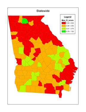
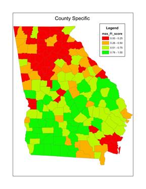
Figure 1. F1 scores by county for the statewide (left) and county-specific (right) decision tree models for weather-based forecasting of prescribed burn activity in Georgia during January-April 2015.
If the burn-forecast model predicts that tomorrow will be a “burn day,” the daily average burn acreage for a county is split into burns of “typical size,” which are assigned to lands owned by prominent burners or distributed randomly to forested areas. Then, the amount of fuels that these burns would consume is estimated using the fuel loads obtained from the Fuel Characteristic Classification System (FCCS) maps and recent fuel moisture data from the fire weather network. Fire emissions then are calculated using emission factors characteristic of the Southeastern fuels and distributed between the boundary layer and the lower troposphere. Finally, these fire emissions are input to a “HiRes2” air quality forecasting system, which consists of WRF (Version 3.6) and CMAQ (Version 5.0.2) models. HiRes2 provides forecasts of not only air quality (O3 and PM2.5), but also impacts on air quality of sources such as power plants, on-road vehicles and prescribed burns by using the Decoupled Direct Method in Three Dimensions (DDM-3D) sensitivity analysis method.
This PB impact prediction system was operated in a daily forecasting mode during the 2015 and 2016 burn seasons (January-April). The burn forecasts were evaluated qualitatively every day against the National Oceanic and Atmospheric Administration (NOAA) Hazard Mapping System Fire and Smoke Analyses for agreement in location and density of the fires and quantitatively against the burn areas from NOAA’s Biomass Burning Emission Product for North America and, at the end of the burn season, against burn areas permitted by GFC. Burn impact forecasts were evaluated using observations of possible PB impacts by the statewide air quality monitoring network. Overall, the forecasts improved significantly from 2015 to 2016, primarily due to the use of the county-specific burn forecast models. The precision, recall, and F1 score for correctly predicting the PB impacts over 32 mg m-3 (the 95th percentile of all observed afternoon PM2.5 concentrations at Georgia’s PM2.5 monitors in 2016) were equal to 19%, 36%, and 25%, respectively.
Parallel research focused on the reasons for the underestimation by satellites of burn areas with respect to records in GFC’s permit database. Cloud cover and leaf cover emerged as two potential reasons. Fire detections by satellites were deficient on cloudy days and the correlation between the satellite-retrieved burn areas and permitted burn areas deteriorated from January to April in deciduous forests as leaves sprouted. To be useful, satellite-derived products need to improve their accuracy in detecting small fires and estimating their burn areas.
Following the development and evaluation of operational fire impact forecasting, research activities focused on the integration of the forecasts into PB and air quality management. We held a stakeholder workshop to discuss how to minimize the air quality impacts of PB while maximizing the use of burns for ecological benefits and wildfire risk reduction. Subsequently, we developed a protocol for incorporating the air quality and impact forecasts into the current prescribed burn permitting process. The protocol involves denying applications or restricting the acreages of the permits on poor air quality days and encouraging burns on days when there are no imminent air quality concerns.
Daily burn area and air quality and burn impact forecasts for each county continue to be posted to our website for use by GFC. This information was found to be useful and potentially beneficial to PB management. Other southeastern states showed interest in extending the forecasts to the entire region. Based on GFC’s comments, we designed a new method to calculate how many acres could be burned in each county without causing any air quality exceedances. The method will use Gaussian plumes to partition the total impact calculated by DDM into impacts of the individual burns. The development of the method and assessment of its benefits were left for future research.
Journal Articles on this Report : 6 Displayed | Download in RIS Format
| Other project views: | All 21 publications | 8 publications in selected types | All 6 journal articles |
|---|
| Type | Citation | ||
|---|---|---|---|
|
|
Davis AY, Ottmar R, Liu Y, Goodrick S, Achtemeier G, Gullett B, Aurell J, Stevens W, Greenwald R, Hu Y, Russell A, Hiers JK, Odman MT. Fire emission uncertainties and their effect on smoke dispersion predictions: a case study at Eglin Air Force Base, Florida, USA. International Journal of Wildland Fire 2015;24(2):276-285. |
R835217 (2012) R835217 (2013) R835217 (2014) R835217 (Final) |
Exit |
|
|
Garcia-Menendez F, Hu Y, Odman MT. Simulating smoke transport from wildland fires with a regional-scale air quality model: sensitivity to uncertain wind fields. Journal of Geophysical Research–Atmospheres 2013;118(12):6493-6504. |
R835217 (2012) R835217 (Final) |
Exit Exit |
|
|
Garcia‐Menendez F, Hu Y, Odman MT. Simulating smoke transport from wildland fires with a regional‐scale air quality model: sensitivity to spatiotemporal allocation of fire emissions. Science of The Total Environment 2014;493:544‐553. |
R835217 (2013) R835217 (Final) |
Exit Exit Exit |
|
|
Hu Y, Odman MT, Chang ME, Russell AG. Operational forecasting of source impacts for dynamic air quality management. Atmospheric Environment 2015;116:320-322. |
R835217 (2014) R835217 (Final) R833866 (Final) R834799 (2015) R834799 (2016) R834799 (Final) |
Exit Exit Exit |
|
|
Huang R, Zhang X, Chan D, Kondragunta S, Russell AG, Odman MT. Burned area comparisons between prescribed burning permits in southeastern USA and two satellite‐derived products. Journal of Geophysical Research--Atmospheres 2018;123(9):4746-4757. |
R835217 (Final) |
Exit |
|
|
Lv B, Hu Y, Chang HH, Russell AG, Bai Y. Improving the accuracy of daily PM2.5 distributions derived from the fusion of ground-level measurements with aerosol optical depth observations, a case study in North China. Environmental Science & Technology 2016;50(9):4752-4759. |
R835217 (Final) R833866 (Final) R834799 (Final) |
Exit Exit Exit |
Supplemental Keywords:
fire detection, burn areas, satellites, burn permits, ozone, particulate matter, PM, PM2.5, smoke exposure, plume modelingRelevant Websites:
SIP-C Smoke Impact Prediction Center Exit
HiRes2 - Air Quality and Source Impacts Forecasting for Georgia Exit
Progress and Final Reports:
Original AbstractThe perspectives, information and conclusions conveyed in research project abstracts, progress reports, final reports, journal abstracts and journal publications convey the viewpoints of the principal investigator and may not represent the views and policies of ORD and EPA. Conclusions drawn by the principal investigators have not been reviewed by the Agency.