
Grantee Research Project Results
2012 Progress Report: Center for Green Infrastructure and Stormwater Management
EPA Grant Number: R835142Center: Center for Integrated Multi‐scale Nutrient Pollution Solutions
Center Director: Shortle, James S.
Title: Center for Green Infrastructure and Stormwater Management
Investigators: Echols, Stuart Patton , Orland, Brian A , Shortle, James S. , Duffy, Christopher , Ready, Richard C , Clark, Shirley E , Gray, Barbara L , Royer, Matthew B
Current Investigators: Echols, Stuart Patton , Orland, Brian A , Royer, Matthew B , Ready, Richard C , Clark, Shirley E , Gray, Barbara L , Shortle, James S. , Saacke-Blunk, Kristen , Wagener, Thorsten
Institution: Pennsylvania State University
EPA Project Officer: Packard, Benjamin H
Project Period: March 1, 2012 through February 28, 2018
Project Period Covered by this Report: July 1, 2012 through June 30,2013
Project Amount: $2,173,026
RFA: Sustainable Chesapeake: A Collaborative Approach to Urban Stormwater Management (2011) RFA Text | Recipients Lists
Research Category: Congressionally Mandated Center , Water , Sustainable and Healthy Communities
Objective:
Project 1
The objective of Project 1 is to understand the cognitive and institutional barriers that currently prevent the adoption of innovative green infrastructure solutions for stormwater management, and to identify ways in which those barriers can be overcome.
Project 2
- Develop visual/verbal “dashboards” that communicate to local decision makers (municipal governments and school boards) the information necessary to portray the implications of stormwater management plans for their facilities via data-coupled 3-D visualization;
- Investigate the effects of introducing data-coupled visualization into the deliberation of stormwater management plans addressing perceived improvements in decision-making processes and timing, and confidence in the outcomes;
- Develop visualization “sets” representing alternative development scenarios and calibrated to the needs of and linkages with other projects.
Project 3 (Part I)
The project addresses the challenges in design and regulatory community standards to implementing green infrastructure and provides computer modeling tools to better predict receiving water impacts of both water quantity and quality. The objective of this project under this Center umbrella is to improve the technical tools available to decision-makers and to understand the technical barriers to implement green infrastructure in the Chesapeake Bay Basin. Two of the goals under Project 3 are (part one) the development and implementation of a Web-based survey of technical personnel involved in stormwater management regarding the current state of the practice and the barriers to implementing the modern tools that are available, and (part two) statistically analyzing the large number of studies that exist in the International BMP database for the design parameters that affect a treatment device’s water quality performance.
Project 3 (Part II)
Design and implementation of green infrastructure requires a spatially explicit, multi-process strategy for assessing and predicting water quantity and quality impacts of urban stormwater flooding, soil degradation and the role of altered residence times of contaminants and flooding on the urban landscape as well as the larger watershed in which it exists. In this research, we are implementing a high-resolution, spatially explicit model that resolves the local effects of current and projected stormwater practices at suburban, urban and urbanizing, watersheds within the Chesapeake Bay Watershed region. The project will evaluate current stormwater practices for flood control and water quality management at three testbeds in the Lancaster, PA, area. The model simulations will evaluate benefits of a range of management techniques (detention, harvesting, etc.) with multiple constraints (flooding, recharge, residence times, etc.). We are developing future climate-landuse-landcover scenarios for the impact and efficiency of green infrastructure within the overall watershed framework.
Project 4
The objective of this project is to measure residents' attitudes toward and preferences over non-hydrological aspects of green stormwater management, including the various ways that stormwater management can affect the built and natural landscape, and to measure residents' willingness to pay for changes in attributes of the landscape that can be affected by green stormwater management approaches.
Project 5
Project 5 will ensure that all of the research conducted by the Center will be authentically connected to decision makers and stakeholders in a high-priority target region in Pennsylvania, thereby achieving greater adoption of green infrastructure and stormwater management practices within communities where they are needed the most. In addition, by engaging key decision makers at all levels, the Center’s outreach and engagement strategy will facilitate Center research outcomes related to understanding the barriers to widespread adoption of green infrastructure approaches to stormwater management in Pennsylvania. Wide dissemination of outcomes is proposed so that key stakeholders will be better able to influence decision makers in their communities across the Chesapeake Bay watershed.
Specifically, the project objectives are to:
Ensure research involves decision makers and communities within the target region.
Engage key community stakeholders within the target region in an advisory capacity to ensure regional relevance of the project.
Fully engage public decision makers and citizens within the target region through conferences that frame issues, barriers, and potential solutions, disseminate outcomes and research results, and make recommendations for influencing decision makers and developing tools to achieve widespread implementation of green infrastructure in Pennsylvania.
Achieve broad external engagement and outreach of research results and project outcomes to a wider citizen audience through the Center’s website.
Progress Summary:
Project 1
Our approach for this project is to conduct and analyze interviews with institutional stakeholders in three Pennsylvania counties with high urban loadings of pollutants and high vulnerability to future urban land conversion in the Pennsylvania portion of the Chesapeake Watershed. Toward that end, we developed an interview protocol and received Human Subjects approval from Penn State’s Office of Research Protections for this study. So far, we have conducted 15 interviews with a total of 22 interviewees involved. The interviewees typically lasted between 1.5 to 2 hours each and were audio recorded. These individuals represent a range of stakeholders, including regulators (at the federal, state and conservation district levels), engineering consultants, township/county supervisors and planners, homeowners, and advocacy groups. We also attended two meetings (an all-day information session in Lancaster County on green infrastructural solutions and a training session by an advocacy group). Ten interviews have been transcribed to date.
Our interview protocol contained questions designed to learn about cognitive and institutional barriers to the adoption of effective stormwater practices and green infrastructural solutions. Our initial literature review identified seven such barriers: (1) incomplete knowledge of hydrological models and regulations; (2) incomplete or incorrect knowledge of green infrastructural solutions and their non-hydrological benefits; (3) lack of an up-to-date and supportive regulatory framework; (4) frame differences among decision makers regarding desired outcomes; (5) lack of training for consulting engineers about current regulations and new technologies; (6) lack of institutional infrastructure that promotes innovations; and (7) insufficient financing.
To identify barriers referenced by our interviewees, we are conducting a grounded theory analysis of the interview data (along with any archival data we collect). We are using Scholari Sage’s NVivo software as a vehicle for coding the data. As the interviews are transcribed, we import the word files into NVivo where we are creating an inductive coding scheme that captures the interviewees’ views on the hydrological and non-hydrological benefits of stormwater management, the extant regulations, how stormwater management decisions are made and their role in these processes, the models they use to make stormwater decisions and the green infrastructure solutions they have employed. In particular, we are focusing on the frames that interviewees are using to understand and discuss stormwater management. This coding scheme will evolve as additional interviews are analyzed (e.g., as new barriers are identified). Once we reach “theoretical saturation” (no new codes are emerging), all of the interviews will be coded using the final coding framework. To date, we have coded two interviews and already have quite an elaborate coding scheme evolving that reflects many of the barriers identified above but also several new ones.
Several preliminary themes are emerging from the analysis. First, the morass and changing nature of regulations at the state and federal levels has been confusing to follow and implementation often conflicts with extant local ordinances. Additionally, Pennsylvania’s regulatory process is particularly cumbersome because of the large number of small townships who must review and adopt local ordinances. Not surprisingly, views on the utility of regulations and green infrastructural solutions vary depending on the type of stakeholder interviewed. Funding to support new green infrastructural initiatives is scarce, and successful implementation of regulations will need to consider how such initiatives can be paid for. Some municipalities are looking into creation of a “utility” that could charge taxpayers for stormwater improvements. However, opposition to federal and state efforts to regulate stormwater management is surfacing in some locations from groups advocating for a strong individual property rights agenda.
The practical implications of this project include gaining a deeper understanding of the barriers that affect how stormwater decisions are made and conflicts that arise among stakeholders. This knowledge can then be used to design subsequent phases of the project in which we will offer workshops to help stakeholders gain greater appreciation of the importance of stormwater management and techniques they can use to solve stormwater problems in the communities.
Project 2
The visual/verbal dashboards intended for this project require a relatively high level of image realism. Several software options were identified as having the potential to be of use to this project: Visual Nature Studio, Maya, Revit, LandFX, CommunityVIZ, and Vue. Conversations with practitioners and other academics who have worked on projects with similar visualization needs revealed that a combination of CommunityVIZ and Visual Nature Studio would provide the ability to produce both the photorealistic images, as well as quick production of data-driven alternate scenarios. CommunityVIZ is user friendly and can be taken into community meetings, where the visualizations can be updated on the fly in response to concerns or preferences. Once the scenarios are hashed out with CommunityVIZ, they can be brought into VNS to create photorealistic renderings. As a result of this research, CommunityVIZ and Visual Nature Studio were purchased for the project.
Following the selection of software tools, the researchers went through a phase of site selection and developing a level of proficiency with the software. The site selection process kicked off with a meeting with the Project 2 researchers and two landscape architecture practices located and working in the study area. The landscape architecture consultants provided a list of potential sites that were visited by the Project 2 team. One site was selected for the initial study and as a test-bed for the overall research protocols.
The landscape architecture consultants provided Project 2 with the raw spatial data for that site. In combination with LiDAR data and other public GIS data available from pasda.psu.edu, the data from the landscape architects were used to test and learn the new software. The result of this process was a photorealistic image that replicated a photograph taken at the selected study site to validate the visualization process (See Fig. 1.)
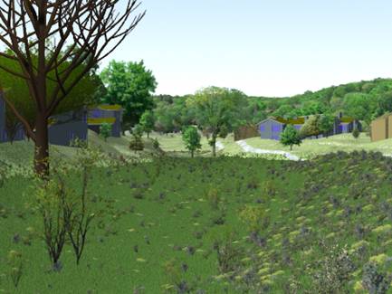
Figure 1: Photorealistic representation of study site #1
Once the software was found to be viable for the specific needs of this project, our focus shifted to the first major collaboration effort with Project 4. In preparation for the choice experiment to be conducted by the Project 4 team, a series of meetings were held to design the instrument.
The Project 2 team has preliminarily decided to systematically create images based on the same spatial template to represent the following attributes: absence-presence of manmade forms, low-high biodiversity, low-high accessibility and recreation, and ephemeral-persistent water. The four attributes are combined and will be represented in low, medium, and high levels in photorealistic visualizations produced in Visual Nature Studio.
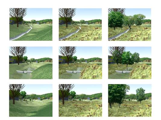
Figure 2: Array: Systematic manipulation of two visual variables
Project 3 (Part I)
For goal (1), a draft survey has been completed and submitted for review by several technical experts not affiliated with this project as part of part one. For goal (2), data have been downloaded and preliminary statistical analyses have been performed as addressed in part two.
Project 3 (Part II)
At this early stage in the project, we have isolated our study areas and have begun to compile all the geospatial data for soils (SSURGO, USDA), geology (PASDA), landuse-land-cover (NLCD), climate (NLDAS-2, NOAA), terrain model (USGS, NED). As part of this effort, we are interpreting “the built environment” geospatial data layers from LIDAR scenes (PASDA). The model is known as the Penn State Integrated Hydrologic Model (PIHM). Historical simulations will be conducted over three areas in the Lancaster area for the climate Reanalysis period (hourly data for 1979-Present). Future climate scenario development will use IPCC projections.
Project 4
During this period, progress has been made on the design of the survey instrument, the sampling frame, and the recruitment protocol. Specifically, the decision context for the following choice question issues have been resolved:
- First, the choice questions will be made in the context of predominantly residential neighborhoods. This decision is made to focus on preferences over landscapes close to the home.
- Second, the choice questions will focus on attributes of common areas of the neighborhood, as opposed to attributes of private property. In this way, we will avoid scenarios where the homeowner is forced to adopt a landscape against his or her will, which we anticipate would lead to high levels of scenario rejection and protest responses.
- Third, it was decided that three specific neighborhoods would be modeled that differ in their residential density (large-lot single family, small-lot single family, and multi -family). Respondents will be asked to choose the model that best matches their own current neighborhood.
- Fourth, two alternative decision contexts were explored. In the first, the respondent is asked to imagine that he or she must move to a new neighborhood. The choice questions would present alternative neighborhoods with varying landscapes. Cost differences among options would enter in the form of differences in neighborhood association fees. In the second, the respondent is asked to imagine different ways that his or her own neighborhood might change its landscape to comply with new stormwater regulations. Cost differences among options would enter in the form of a stormwater management fee. Respondents may have difficulty imagining large changes in the landscape of their current neighborhood. Because a stormwater management fee is new and unfamiliar to many residents, they may find it objectionable as a payment vehicle. For these reasons, we will use the first decision context to frame the choice questions.
- Fifth, it was concluded that, for the purposes of this project, it is not necessary to generate a random sample of all residents in the study community. We want residents who live in neighborhoods similar to one of the three modeled neighborhoods. A convenience sample of such residents would be acceptable. Survey design work with residents (focus groups, one-on-one tests) do not need to be conducted in the target community.
- Sixth, two survey versions will be prepared, and a split sample design will be used to compare the results. The first version will motivate the differences in landscape through a discussion of green approaches to stormwater management. The second version will make no mention of stormwater until after the choice questions have been answered.
Project 5
A summary of accomplishments over the first reporting period are as follows:
-
Work with Project 1 researchers to identify decision makers for first round interviews
Project 5 team members worked closely with Project 1 team members to outreach to a diverse group of decision makers involved in stormwater management decisions in the target region and facilitate first round interviews. This task has allowed Project 5 to squarely meet one of its primary objectives: ensuring the research is authentically connected to decision makers and stakeholders in the high-priority target region of the Lower Susquehanna.
-
Recruit stakeholders in target region to serve on Community Partners Council
Project 5 team members consulted with all research teams on a proposed list of Community Partners Council members and then actively recruited stakeholders to serve on the CPC. CPC membership is as follows and represents a diverse group of stakeholders and decision makers from the target region:
- John Bingham, Supervisor, East Hempfield Township
- Matt Bonanno, P.E., Regional Manager of Civil Engineering Services, HRG, Inc.
- Andrew Gavin, Manager, Monitoring and Protection, Susquehanna River Basin Commission
- Michael LaSala, Senior Project Manager, LandStudies, Inc.
- Steve Letavic, Township Manager, Londonderry Township
- Fritz Schroeder, Director, Lancaster LIVE Green
- Shannon Williams, P.E., Executive Director, Harrisburg Authority
The CPC will hold its first meeting in the coming months.
-
Recruit members to serve on Science Advisory Committee
Candidates for the Science Advisory Committee (SAC) were developed and vetted with all research team members. SAC members were then recruited, after approval from the EPA project advisor. Members of the SAC include:
- Michele Adams, P.E., LEED AP, President, Meliora Design LLC
- Harry Campbell, PA Executive Director, Chesapeake Bay Foundation
- Kelly Gutshall, RLA, ASLA, President, LandStudies, Inc.
- Wesley Horner, AICP, Senior Advisor for Water Resources, Brandywine Conservancy
- Paul Leisnham, Ph.D., Assistant Professor of Ecology and Health, University of Maryland
- Ken Murin, P.E., Chief, Division of Waterways, Wetlands and Stormwater Management, PA Department of Environmental Protection
The SAC will hold its first meeting with researchers in the coming months.
-
Schedule date, select venue and begin planning initial kickoff conference
Project 5 team members have secured a date and venue for an initial kickoff conference with local stakeholders in the target region. The conference will be held on June 26, 2013, at the Penn State Harrisburg campus. A diverse group of stakeholders and decision makers involved in stormwater management will be invited. Sessions will include facilitated discussions between researchers and conference attendees so research plans can be refined based on input and barriers to adoption of green infrastructure can further be explored.
Project 5 team members will continue to lead the planning effort for this conference over the next several months, with significant input from all research team members.
Future Activities:
Project 1
The next steps in Project 1’s work include:
- Conducting approximately 10 additional interviews (including some with developers, opposition groups and smaller, rural townships)
- Observing a few public meetings where new stormwater ordinances and utilities and being proposed.
- Completing transcription, coding and analysis of interviews.
- Preparing a report on cognitive and institutional barriers that surfaced during the analysis. A preliminary report will be prepared for our kick-off meeting on June 28, 2013.
- Generate preliminary recommendations based on our findings.
Project 2
The next steps in Project 2’s research are:
- Complete the series of photorealistic visualization necessary to test the Project 4 Instrument.
- Refine the visualizations based on outside feedback.
- Prepare for the pre-workshop survey for the pilot Stormwater Planning Workshop.
- Prepare for the pilot Stormwater Planning Workshop to be held at the end of year 2.
Project 3 (Part I)
The next steps in this Project include:
- The completed survey (Goal 1) will be completed and administered to professionals (technically oriented) who are working in the Bay basin.
- The International BMP database data analysis (Goal 2) will be continued, with much of the work focusing on the relationships between water quality and design parameters such as drainage area, peak flows, total volume, etc.
Project 3 (Part II)
The next steps in this project include:
- Fully implement the models over each of the three watersheds. This work will first be completed without the built environment overlay to establish a base for comparison (e.g., forest land cover or other).
- Once interpretation of LIDAR is complete, we should have reasonable representations of the “built” environment in digital form ready for simulation.
- Published results for soil hydraulic property changes as a function of landuse will be implemented in the model and critical areas will be identified (e.g., flood prone areas, poor drainage locations, etc.).
- Hypothetical scenarios for how green infrastructure might improve critical areas and lead to a more coherent design will be evaluated within the virtual model environment described below.
Project 4
Next steps in this project are:
- Design a draft survey instrument
- Test the draft survey instrument using verbal protocols with a convenience sample of residents
- Develop sampling and recruitment protocols
- Finalize survey instrument
- Obtain human subjects clearance
- Implement survey
- Analyze data
Project 5
Major activities and objectives for the subsequent reporting period include:
- Work with research team members to plan and hold first CPC meeting.
- Work with research team members to plan and hold first SAC meeting.
- Finalize planning and hold kickoff conference at Penn State Harrisburg (June 26, 2013).
- Continue to work with research team leaders to help identify stakeholders and sites within the target region willing to serve as research subjects and test beds.
- Provide assistance and advice to research team members developing the Center’s website regarding outreach and engagement content.
Journal Articles: 3 Displayed | Download in RIS Format
| Other center views: | All 22 publications | 5 publications in selected types | All 3 journal articles |
|---|
| Type | Citation | ||
|---|---|---|---|
|
|
Leonard L, Duffy CJ. Essential Terrestrial Variable data workflows for distributed water resources modeling. Environmental Modelling & Software 2013;50:85-96. |
R835142 (2013) R835142 (2015) R835142 (Final) |
Exit Exit Exit |
|
|
Yu X, Bhatt G, Duffy C, Shi Y. Parameterization for distributed watershed modeling using national data and evolutionary algorithm. Computers & Geosciences 2013:58;80-90. |
R835142 (2015) R835142 (Final) |
Exit Exit Exit |
|
|
Yu X, Duffy C, Zhang Y, Bhatt G, Shi Y. Virtual experiments guide calibration strategies for a real-world watershed application of coupled surface-subsurface modeling. Journal of Hydrologic Engineering 2016;21(11):04016043. |
R835142 (2016) |
Exit |
Supplemental Keywords:
Environmental disputes, Virtual environmental design, integrated models, geospatial data services, Community, engagement, stakeholders, decision makers, watersheds, stormwater, water quality, nutrients, Chesapeake Bay, Susquehanna River, water, land, outreach, public participation, green infrastructureRelevant Websites:
Penn State Integrated Hydrologic Model (PIHM) Exit
Progress and Final Reports:
Original Abstract Subprojects under this Center: (EPA does not fund or establish subprojects; EPA awards and manages the overall grant for this center).
R835142C001 Decision Making – Cognitive and Institutional Barriers
R835142C002 Green Infrastructure Design and Visualization
R835142C003 Hydrologic and Water Quality Modeling for Green Infrastructure
R835142C004 Non-Hydrological Benefits and Citizen Preference
R835142C005 Public Engagement and Outreach
The perspectives, information and conclusions conveyed in research project abstracts, progress reports, final reports, journal abstracts and journal publications convey the viewpoints of the principal investigator and may not represent the views and policies of ORD and EPA. Conclusions drawn by the principal investigators have not been reviewed by the Agency.