
Grantee Research Project Results
2011 Progress Report: Evaluation of Sanitary Sewers as a Source of Pathogen Contamination of Municipal Water Supply Wells
EPA Grant Number: R834869Title: Evaluation of Sanitary Sewers as a Source of Pathogen Contamination of Municipal Water Supply Wells
Investigators: Bradbury, Kenneth R. , Borchardt, Mark , Gotkowitz, Madeline B
Institution: University of Wisconsin - Madison , Marshfield Clinic Research Foundation , Wisconsin Geological and Natural History Survey
EPA Project Officer: Page, Angela
Project Period: June 1, 2011 through May 31, 2013 (Extended to December 31, 2013)
Project Period Covered by this Report: June 1, 2011 through May 31,2012
Project Amount: $598,580
RFA: Advancing Public Health Protection through Water Infrastructure Sustainability (2009) RFA Text | Recipients Lists
Research Category: Drinking Water , Water
Objective:
This project investigates the sources and transport pathways of human viruses from a presumed source in near-surface sanitary sewers to deeply cased municipal water-supply wells. The research objectives are to 1) quantify the presence of pathogenic viruses in groundwater near urban sewer systems in hydrogeologic settings appropriate for loading groundwater; 2) establish correlations between virus presence and sewer characteristics such as age, construction, materials, depth, and overall condition; 3) evaluate the transport pathways of pathogenic viruses to deep supply wells; and 4) use numerical modeling to develop estimates of the amount of sewer exfiltrant reaching groundwater and the probability of contamination of nearby water supply wells, and to extrapolate this information to other areas.
The initial phase of the project included the selection, instrumentation, and hydrogeologic investigation of monitoring sites associated with municipal wells in the cities of Madison and Fitchburg, Wisconsin. Madison Unit Well 7 was the first site completely instrumented for sampling and hydraulic testing. Extensive hydrogeologic characterization and groundwater sampling at this site provided a proof-of-concept testing ground as the remaining six monitoring sites were established. Work conducted at the Well 7 site resulted in identification of fractured intervals in the shallow bedrock formations, some of which are associated with distinct water chemistry signatures. Early project data from this first of seven field sites indicates that fractures may play a significant role in the transport of wastewater derived contaminants through the upper aquifer (Gellasch, et al., 2012; Gellasch, 2012).
Progress Summary:
Development of all seven project sites was completed in May 2012. Overall, six field sites are associated with nearby municipal wells while the seventh monitoring site is approximately 1000 meters from a municipal well. Sites consist of the municipal well itself and two or three monitoring wells completed at various depths in the upper aquifer; distances between the monitoring wells and the municipal well range from 7 to about 150 meters. Each site is near sanitary sewers of known construction. These sewers range in age from about 10 to 75 years old. Figure 1 shows typical site instrumentation (Madison Unit Well 7).
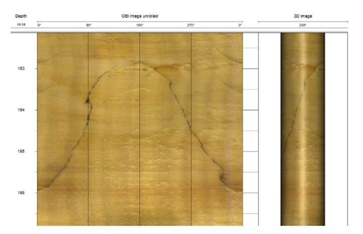
Drilling for monitoring well installation provided some opportunity for geophysical logging and hydraulic testing at each site. Borehole geophysical logging was useful for identifying bedrock stratigraphic units, fractures and other geologic heterogeneities that are potential pathways for virus transport. In particular, optical borehole imaging (OBI) logs have been particularly useful in showing that fractures and voids in the sandstone aquifer are much more common than previously assumed. This is an important finding of the study so far. Figure 2 shows an example of the appearance of a near-vertical fracture in one of the monitoring wells installed. Identifying the locations of such features in the subsurface informed the design of the groundwater monitoring wells at each site.
Instrumentation of all sites was completed in early June 2012. This marked the beginning of twelve months of groundwater sample collection, during which 24 rounds of sampling will be completed. Sixteen monitoring wells and sanitary sewer effluent are sampled twice per month, and six municipal supply wells are sampled once per month. Samples from all wells were also collected for major ions and environmental isotopes. Monitoring at each site also includes collection of water levels at 20-minute intervals with submersible, recording pressure transducers.
To improve our ability to track sample collection, transport to the laboratory, and project results, the research team developed an application for use of tablet computers by field personnel. This allows groundwater samplers to upload sample tracking, field measurements, and equipment information at the time of sample collection to the laboratory information system (LIMS) at the USDA-Agricultural Research Service. This significantly enhances coordination between the laboratory, located in central Wisconsin, and project personnel at the Wisconsin Geological and Natural History Survey (WGNHS) in Madison, Wisconsin.
Work to develop the data collection and tracking system continued with construction of a project-specific GIS and Access database. Housed at the WGNHS, this contains essentially all information about each site, monitoring well, municipal supply well, as well as the water quality data as it is returned from laboratories. This will ultimately improve sample validation as well as data interpretation.
Project expenditures are generally proceeding as forecast in the project budget. An adjustment to vehicles used for sampling was necessary to avoid excessive costs in the transportation category. This simply meant increased reliance on WGNHS fleet vehicles rather than rental of dedicated field vehicle for sampling. We anticipate completing all projects tasks within budget.
Figure 1. Cross section of typical field site (Madison Unit well 7) with location of monitoring wells with respect to the unit well. Numbers next to each monitoring well screen and the Unit Well 7 borehole are hydraulic head elevations (in meters) from May 2012 while the aquifer system was at steady state during well maintenance
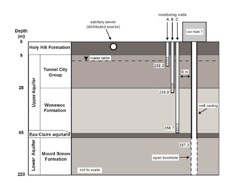
Figure 2. Optical borehole imager (OBI) image obtained from monitoring well C at the Unit well 7 site (see Figure 1). The image shows a high-angle (near vertical) fracture in sandstone. Such fractures might provide pathways for rapid vertical movement of water and viruses from near-surface sources to the municipal well. Depth units are in feet.
Future Activities:
Work on the project continues with the primary focus on sample collection and analysis. Once sampling is completed in May 2013, efforts will shift significantly, with the final 3 months of work dedicated to data interpretation, modeling, and preparation of reports and papers
Journal Articles on this Report : 2 Displayed | Download in RIS Format
| Other project views: | All 6 publications | 3 publications in selected types | All 3 journal articles |
|---|
| Type | Citation | ||
|---|---|---|---|
|
|
Gellasch CA, Bradbury KR, Hart DJ, Bahr JM. Characterization of fracture connectivity in a siliciclastic bedrock aquifer near a public supply well (Wisconsin, USA). Hydrogeology Journal 2013;21(2):383-399. |
R834869 (2011) R834869 (2012) |
Exit Exit Exit |
|
|
Gellasch CA, Wang HF, Bradbury KR, Bahr JM, Lande LL. Reverse water-level fluctuations associated with fracture connectivity. Groundwater 2014;52(1):105-117. |
R834869 (2011) R834869 (2012) |
Exit Exit Exit |
Progress and Final Reports:
Original AbstractThe perspectives, information and conclusions conveyed in research project abstracts, progress reports, final reports, journal abstracts and journal publications convey the viewpoints of the principal investigator and may not represent the views and policies of ORD and EPA. Conclusions drawn by the principal investigators have not been reviewed by the Agency.