
Grantee Research Project Results
2011 Progress Report: Protecting Drinking Water by Reducing Uncertainties Associated with Geologic Carbon Sequestration in Deep Saline Aquifers
EPA Grant Number: R834382Title: Protecting Drinking Water by Reducing Uncertainties Associated with Geologic Carbon Sequestration in Deep Saline Aquifers
Investigators: Roy, William R. , Benson, Sally M. , Berger, Peter , Lin, Yu-Feng Forrest , Mehnert, Edward , Panno, Samuel V. , Ray, Chittaranjan , Butler, Shane K , Strandli, Christin , Yoksoulian, Lois
Current Investigators: Roy, William R. , Storsved, Brynne A , Hackley, Keith C , Lin, Yu-Feng Forrest , Rice, Richard J , Butler, Shane K , Benson, Sally M. , Kelly, Walton R , Freiburg, Jared T , Panno, Samuel V. , Ray, Chittaranjan , Strandli, Christin , Mehnert, Edward , Krothe, J. , Yoksoulian, Lois , D'Alessio, Matteo , Krothe, N.C. , Adams, Nathaniel , Berger, Peter , Askari-Khorasgani, Zohreh
Institution: University of Illinois Urbana-Champaign , Stanford University , University of Hawaii at Honolulu
Current Institution: University of Illinois Urbana-Champaign , Hydrogeology, Inc. , Illinois State Geological Survey , Illinois State Water Survey , Isotech Laboratories , Stanford University , University of Hawaii at Honolulu
EPA Project Officer: Aja, Hayley
Project Period: November 16, 2009 through November 15, 2014
Project Period Covered by this Report: November 16, 2010 through November 15,2011
Project Amount: $897,225
RFA: Integrated Design, Modeling, and Monitoring of Geologic Sequestration of Anthropogenic Carbon Dioxide to Safeguard Sources of Drinking Water (2009) RFA Text | Recipients Lists
Research Category: Drinking Water , Water
Objective:
Task 1: Monitoring at Natural Gas Storage Sites (Technical Leader: E. Mehnert)
The goal of this task is to improve our understanding of the storage field geology and the hydrodynamics of fluid flow within the Mt. Simon Sandstone. This goal will be accomplished through the analysis of available and new pressure monitoring data from 10 natural gas storage fields completed in the Mt. Simon Sandstone. This task has three components—compile available geologic and pressure data, install pressure transducers, and determine pressure response of the gas storage fields.
Task 2: Vertical pressure profiles for monitoring CO2 and brine migration: research and validation of the Westbay system to Reduce Risk (Technical Leader: S. Benson)
The objective of this task is to develop and demonstrate methods for monitoring migration and potential leakage of CO2 using multilevel pressure transient measurements. The methods developed will be applied to the Illinois Basin-Decatur Project, where the Westbay multilevel monitoring system is installed to measure the pressure buildup during CO2 injection.Task 3: Enhancement of Regional Flow and Transport Models to Reduce Risk (Technical Leaders: Y.-F. Lin, Illinois State Water Survey and C. Ray, University of Hawaii)
The goal of Task 3 is to refine a groundwater flow model (MODFLOW/SEAWAT model) to simulate the possible flow field based on the development of commercial-scale, geologic carbon sequestration within Mt. Simon. The ultimate goal of this model is to reduce the risk of groundwater contamination primarily from upgradient brine migration within the Mt. Simon resulting from geologic carbon sequestration (GCS). GCS will be modeled at the basin scale using TOUGH2-MP. Risk can be reduced via a reduction in parameter uncertainty in the MODFLOW/ SEAWAT and TOUGH2 models. SEAWAT is a variable density formulation of MODFLOW.
Task 4: Geochemical Investigations (Technical Leader: W. Roy)
The goal of this task is to conduct laboratory-scale geochemical investigations that will yield useful information on how carbon sequestration will change the chemical and mineralogical composition of the subsurface-injection system.
Task 5: Saline groundwater discharge from the Illinois Basin (Technical Leader: S. Panno):
This task will provide baseline data for discharge estimates and geologic sources of naturally occurring, surface discharge of saline groundwater. These data then can be compared with long-term, post sequestration data. Sequestration of large volumes of CO2 into the Illinois Basin, over an extended period, could affect or alter groundwater flow in deep formations. Changes in discharge quantities and qualities (including geochemical signatures) would provide useful indicators of the possible long-term impacts of sequestration. In addition, such information would be helpful in modeling efforts for determining the effects of greater pressures on the Mt. Simon Formation as a direct result of injection of CO2.
Progress Summary:
Task 1: Monitoring at Natural Gas Storage Sites (Technical Leader: E. Mehnert)
We continued to compile available geologic data from ISGS records, the literature, and the Illinois Commerce Commission (ICC). These data have been summarized in a 19-page document that we call the “Almanac,” which includes data for 18 sites—active, abandoned, and tested storage projects. We reviewed and compiled data from gas storage company files for these fields—Manlove (Champaign Co.), Tuscola (Douglas Co.), Sciota (McDonough Co.), Shanghai (Warren and Mercer Co.), and Waverly (Morgan Co.). Although the Tuscola field was abandoned in the 1990s, we were able to recover four boxes of valuable data from the Southern Pipeline Group, which had acquired Panhandle Eastern assets via a merger. These boxes include data from core collected from four wells, a 15-day pumping test, and for 17 Mt. Simon wells. Because Tuscola is less than 50 miles away from Decatur, these data are considered especially valuable. In addition, project staff compiled a 32-page, preliminary report for the Ancona gas storage field comparing results from a 57-day pumping test and laboratory permeability data. Finally, no pressure transducers have been installed to date.
Task 2: Vertical pressure profiles for monitoring CO2 and brine migration: research and validation of the Westbay system (Technical Leader: S. Benson)
Based on data provided in the open literature, including a sonic porosity log and corresponding calculated horizontal permeability from a well in Fayette County, Illinois, with stratigraphy that closely resembles the stratigraphy at the Illinois Basin - Decatur Project, we have developed a geologic model that can be subjected to various combinations of homogeneity/heterogeneity and isotropy/anisotropy conditions. So far, we have limited our study to five basic system scenarios: (1) homogeneous, isotropic; (2) homogeneous, anisotropic; (3) heterogeneous, isotropic; (4) heterogeneous with a high degree of anisotropy; and (5) heterogeneous with a lesser, more realistic degree of anisotropy. For the heterogeneous scenarios, the system consists of 30 distinct layers, including six layers in the seal, and one uniform, thick layer above the seal. Supercritical CO2 is injected into the bottom of the storage reservoir (for the heterogeneous scenarios into two high permeability layers) with a total of 1 million metric tons injected over 3 years, as is the specification for the Illinois Basin - Decatur Project.
Using the TOUGH2 multiphase flow simulator with the ECO2N equation of state, we have performed simulations to predict the pressure buildup at a monitoring well 255 m from the injection well. In addition to performing simulations with CO2 injection, we also have performed simulations with pure water injection, assuming equivalent volumetric injection flow rates. The purpose of this is to detect what pressure responses are due uniquely to the presence of CO2. The pressure transients are being analyzed in two ways. First, we examined the pressure buildup at six distinct depths, with four monitoring points assigned to the storage reservoir (including at the depth of injection), one monitoring point in the seal, and one monitoring point in the aquifer above the seal. Second, we examined the maximum information obtainable (i.e., we assumed that we had pressure measurements at all depths at the monitoring well, limited only by the number of grid cells in the vertical direction). From this, vertical pressure gradients were calculated as a function of time and normalized by the initial hydrostatic pressure. The purpose of investigating these normalized vertical pressure gradients is twofold; first, we are interested in knowing where the CO2 and displaced brine migrate in the reservoir, and changing vertical pressure gradients should indicate some vertical flow. Second, we are interested in whether additional information can be obtained through the addition of more monitoring points.
Through our analyses of multilevel pressure measurements, we have been able to identify diagnostics for reservoir structure and CO2 plume migration. We have found that all five system scenarios of homogeneity/heterogeneity and isotropy/anisotropy give rise to large, detectable pressure buildups for both CO2 and water injection, and all system scenarios yielded unique CO2 plume migration. Distinct pressure buildups for the different system scenarios indicated that heterogeneity/anisotropy greatly impacts the pressure response. For the first few months, CO2 injection and water injection gave rise to identical pressure buildups, suggesting that the initial deviation between the different scenarios resulted from system heterogeneity/anisotropy and was independent of the fluid migrating in the reservoir.
Pressure transients at individual monitoring points appear diagnostic of location (depth) of the CO2 plume when they are normalized by the pressure buildup at the depth of injection. Pressure buildups normalized by the pressure buildup at the depth of injection exhibit unique features for (1) a CO2 plume that is sufficiently close to the monitor, and (2) a CO2 plume that has migrated vertically past the depth of the monitor. In particular, the normalized pressure buildups appear to exceed unity when the CO2 plume is sufficiently close to the monitor, whereas a subsequent decline in the normalized pressure buildup can be expected for a plume that migrates vertically past the depth of the monitor.
Vertical pressure gradients normalized by the initial hydrostatic pressure provide (1) a clear representation of system heterogeneity soon after start of injection, and (2) a strong indication of the location (depth) of the injected CO2. Anomalous vertical pressure gradients prior to the CO2 arriving at the monitoring well can be attributed to anomalous vertical aqueous flow caused by water displacement because of the advancing CO2 plume. Once the CO2 reaches the monitoring well, large spikes in the vertical pressure gradients were observed. Our findings thus far suggest that multilevel pressure measurements extending down to the depth of injection will provide a very useful method for monitoring CO2 (and displaced brine) migration.
For the five system scenarios studied, the seal has been sufficiently impermeable to prevent leakage. It nevertheless seems reasonable to anticipate that a leak through the seal should give rise to a subsequent decline in the normalized pressure buildup above the seal once the CO2 has leaked above that monitoring point, just as has been the case in the storage reservoir.
Task 3: Enhancement of Regional Flow and Transport Models to Reduce Risk (Technical Leaders: Y.-F. Lin, Illinois State Water Survey and C. Ray, University of Hawaii)
The initial salinity concentration of the SEAWAT2000 model has been updated based on Zhou et al (2010). The salinity in the Mt. Simon sandstone also has been described by Nicholas et al. (1987) and Visocky (1997), but comparisons of the three papers is difficult because of the different areas covered and associated elevations of the stratigraphic top of the Mt. Simon. For example, the current SEAWAT2000 model has an elevation range of -980 to -6,538 ft (elevations are below sea level), and the concentration data from Nicholas et al. (1987) were based on elevation range of -600 to -3,475 ft. In addition, Visocky (1997) did not provide information on the vertical distribution of the chloride concentrations in all modeling layers. Thus, the initial salinity concentration was interpolated based on the elevation described in Zhou et al. (2010). Also, the initial salinity concentration in Lake Michigan was set to zero because it is a freshwater lake.
The current SEAWAT 2000 model is a steady-state model. Figure 1 shows modeling results from SEAWAT, specifically the salinity distribution in the Mt. Simon. Currently, head and salinity concentration with and without injection are very similar. One possible reason is that the transport convergence criteria in the SEAWAT 2000 model is too small, and causes pre-convergence. The model parameters for transport convergence are still under investigation. The next improvement is to increase the transport time step that should improve the accuracy of the salinity transport.
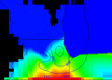
Figure 1. SEAWAT output showing the salinity concentration [lb/ft3] at the bottom of Mt. Simon with injection.
Regarding the relative permeability and the capillary pressure functions in the TOUGH model, Drs. Mehnert, Ray and Matteo D’Alessio (University of Hawai’i post-doc) met in June 2011 to review progress and plan efforts for the next reporting period. Since the meeting, literature reviews have been conducted on these topics:
- Mercury injection capillarity pressure testing—utility and application.
- Relative permeability, saturation and pressure models—background and how to convert between Brooks-Corey and van Genuchten models.
- Compilation of van Genuchten model parameters for sandstones.
The information from these literature reviews will improve input data selection for basin-scale TOUGH2-MP modeling.
Task 4: Geochemical Investigations (Technical Leader: W. Roy)
During the second year, six plugs of the Mt. Simon Core were drilled from the CCS #1 core from the Illinois Basin - Decatur Project. The six plugs were specifically chosen because they appeared to represent the variability of the portion of the core that was available for this project. The depths of the plugs ranged from 6,409 to 6,778 feet. Each plug was cut into two or three slices. A slice was placed into a Parr pressure reactor with synthetic brine, and reacted with super-critical carbon dioxide at 323 K (50º C) at 20.7 MPa (3,000 psig) pressure for 6 months. These experiments have been completed. The liquid samples have been chemically characterized using conventional electrodes, ion chromatography, and inductively coupled argon plasma spectroscopy. The analytical results were used as input to the geochemical model React®, which is part of Geochemist’s Workbench®. The experiment plug that was in the pressure reactor and a control plug (set aside for comparisons) are being chemically and mineralogical characterized using x-ray diffraction, x-ray fluorescence, plane-light microscopy, scanning electron microscopy—energy dispersive x-ray spectroscopy, and cathodoluminescence. Comparison of the control slices with the experiment slices is ongoing and should be complete by early 2012.
Although not included in the project proposal, an experiment was conducted in which slices of the Mt. Simon Sandstone were simultaneously exposed to the brine and carbon dioxide. Four rock slices were each placed into a reactor such that the lower part of the slice was submerged below the surface of the brine while the upper part of the slice was exposed to the brine-rich gas phase. The goal of this experiment was to examine how the gas phase reacts with the sandstone at 323 K (50º C) at 20.7 MPa (3,000 psig) pressure for 6 months. Both the control and experiment slices are being characterized by plane-light microscopy, scanning electron microscopy—energy dispersive x-ray spectroscopy, and cathodoluminescence.
Also during the second year, experiments were designed and initiated with the primary seal at the Illinois Basin - Decatur Project: the Eau Claire Formation. Based on experience gained during the first year, a kinetic experiment was designed with three slices collected from four plugs of the Eau Claire from the CCS #1 core. Each set of slices is being exposed to supercritical CO2 at 316 K (43º C) and 16.8 MPa (2,430 psig) pressure for 3, 6 and 9 months. We anticipate that this type of experiment with a potential sequestration seal had not been conducted before. It has the potential to yield rates-of-reaction information in a worst-case scenario in which carbon dioxide-saturated brine is in contact with the confining layer.
Task 5: Saline groundwater discharge from the Illinois Basin (Technical Leader: S. Panno):
During the first year, we identified naturally occurring saline anomalies throughout the Illinois Basin (in Illinois, southern Indiana, Kentucky and northern Tennessee) as springs or localized saline seeps into fresh shallow drift aquifers. Many of these springs were of historic significance. In the course of this investigation, more than 30 locations of upwelling saline groundwater within the Illinois Basin have been identified. We have sampled all but five of these locations and are awaiting complete chemical and isotopic analyses on each. Available data indicate that their geologic formations of origin range from Cambrian- through Pennsylvanian-age based on halide ratios. Our results show that the saline springs of the Illinois Basin are coincident with geologic structures within the basin (faults, folds), and are coincident with the margins of the basin.
During the second year, we sampled a newly drilled private well southern Illinois that intersected the Bradford Shaw Fault zone near Makanda, Illinois. The well is unique in the area in that it contained a chloride concentration of more than 400 mg/L and a fluoride concentration of more than 5 mg/L. These concentrations are highly unusual for the area; the occurrence of this groundwater constitutes a saline seep up the fault zone and further supports our hypothesis that the saline seeps/springs within the Illinois Basin are following structural pathways along upward hydraulic gradients. The elevated fluoride concentration within this groundwater is somehow related to economic fluorite deposits located about 50 miles south of the well.
Additional samples of brines from the Cambrian-age Mt. Simon Sandstone were collected from Mahomet and Danville, Illinois, for comparison with our spring samples and brines being collected at the Illinois Basin - Decatur Project. The brine sample from Mahomet, Illinois, was collected from one of the gas injection wells owned by People’s Gas. The brine sample from Danville was collected from a waste-injection well drilled in 1972 that was abandoned after the company encountered problems with the well. The brine sample was taken by Ross Brower of the ISGS (retired) who collected the sample in 1972 and saved it for anyone who might be interested in analyzing it. Mr. Brower generously provided us with the sample, and halides were determined from the nearly 40-year-old sample; the halides should not change over time, whereas cations and redox-sensitive ions would be susceptible to reactions that include precipitation and adsorption. The chemical results from both samples were what would be expected for brines from the Cambrian strata based on samples collected at the Decatur, Illinois site.
During field work in the Vermilion Salines (east-central Illinois) area, and with the help of a local, long-time resident, we were able to locate an abandoned well drilled in 1910 and located 3 miles northeast of the actual Vermilion Salines location. The well is under flowing artesian conditions and discharges saline groundwater to the surface creating a dead zone along it surface flow path (Figure 2). The sodium chloride concentration in the groundwater (50,000 mg/L) is very close to that estimated from old records of salt production at the Vermilion Salines (60,000 mg/L).
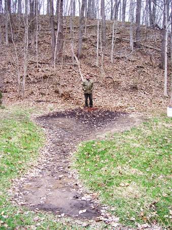
Figure 2. Rick Rice stands near an open borehole drilled in 1910 into Pennsylvanian strata that is discharging saline groundwater at the base of a steep hill near the Vermilion Salines salt works and creating a dead zone between the well and a small stream. The chloride concentration of this water is identical to that of the now buried springs of the salt works.
Two well-known “mineral springs” located in state parks in Illinois (Dixon Springs and Siloam Springs) were sampled and found to have salinities within background concentrations (1 to 15 mg/L). Interestingly, Dixon Springs (Fig. 3) is associated with a geologic structure, whereas Siloam Springs is not. Consequently, “mineral springs,” even those associated with geologic structures, are not necessarily saline or of relatively deep origins.
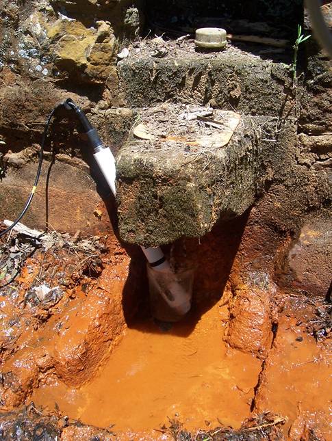
Figure 3. Mineral springs within Dixon Springs State Park in southern Illinois are rich in iron but have no saline component indicating a near-surface source for the springs. Here, we are collecting field parameters of the spring water using a Hydrolab.
We have sampled a private, high-chloride (250 mg/L) well in the Mahomet aquifer located near the Decatur, Illinois CO2 Sequestration site on six occasions (the last being November 4, 2011). The installation of a new water softener at the residence resulted in rerouting of the softened water to the outside spigot from which we collected our sample. This resulted in bad samples for January, May and August of 2011. We now have resolved the problem and have included a neighboring well whose water is the most saline within the Mahomet aquifer (Cl = 500 mg/L) and is the closest to the geologic structure through which the saline groundwater is migrating. This latter well has now been sampled three times. All samples to date were collected prior to injection of CO2 at the Decatur site.
Overall, we have been able to identify the formations of origin of most of the saline samples collected. Consequently, we should be able to identify, with reasonable certainty, the origin of all saline spring waters discharging from within and at the margins of the Illinois Basin. We are currently searching for the locations of five additional saline springs near Murphysboro, Illinois, and western Illinois that were last accessed before 1900.
Future Activities:
Task 1: Monitoring at Natural Gas Storage Sites (Technical Leader: E. Mehnert)
In January of 2012, a University of Illinois student will be hired to help analyze the Mt. Simon aquifer tests data, starting with the Ancona and Tuscola pumping tests. We will continue searching for useful data from the natural gas storage companies and FERC. Our efforts seem to be complicated by the 2011 merger (completed 12/09/2011) between Nicor and AGL. Nicor operates 10 natural gas storage fields in north-central Illinois. Hopefully, Nicor staff availability will improve in 2012. Dr. Mehnert is scheduled to present information about basin-scale modeling of CO2 Sequestration in the Illinois Basin at these meetings:
Task 2: Vertical pressure profiles for monitoring CO2 and brine migration: research and validation of the Westbay system (Technical Leader: S. Benson)
- Complete a geologic model based on drilling and log data from the Illinois Basin - Decatur Project (i.e., update the current geologic model using real data)—has been started.
- Conduct sensitivity analyses on permeability values in particular but also on other important geologic parameters.
- To the extent possible, make a rough estimate of the ideal placement and number of pressure monitors.
- Introduce an intentional leakage in the simulation model to confirm the hypothesis on how a leak would show up in the pressure response above the seal.
- To the extent possible, establish a rough relation between geologic/fluid parameters and pressure response (i.e., a forward model).
- Develop an inverse modeling method for interpreting pressure measurements at individual monitoring points such that information on CO2 migration and potential leakage can be obtained.
- Perform inversion simulation runs.
- Interpret the pressure transient data from the Illinois Basin-Decatur Project (test site).
Task 3: Enhancement of Regional Flow and Transport Models to Reduce Risk (Technical Leaders: Y.-F. Lin, Illinois State Water Survey and C. Ray, University of Hawaii)
In the future, we will add a feedback loop and pass information to TOUGH2-MP, allowing TOUGH2-MP to be updated with SEAWAT-generated data (e.g., head, density). In early 2012, Dr. Mehnert will complete the development of the next generation, geologic model and run TOUGH2-MP using this geologic model. When testing the simulated salinity with and without CO2 injection, the difference is not that significant. Lin will investigate these differences in SEAWAT 2000 model output. At this time, time step, concentration gradient and convergence criteria will be investigated.
Task 4: Geochemical Investigations (Technical Leader: W. Roy)
New research areas
For the third year, two additional research areas have been informally added to the scope of Task 5. A literature review and method development, and preliminary experiments have begun on two scoping projects related to shallow-groundwater quality above the current Illinois Basin - Decatur Project and other potential geosequestration sites within the Illinois Basin. These projects include the investigation of interactions between CO2 and organic-rich portions of shale in reservoir seal rocks organic-rich shallow sediments.
Shale study
Statement of research goal and scientific significance
The goal of the shale study is to observe the behavior of dispersed organic material (bituminite) in high-pressure, CO2-rich environments within the New Albany and Maquoketa shale, two of the reservoir seals located above the Mt. Simon and Knox groups, both of which are proposed CO2 storage reservoirs in the central Illinois Basin. The Maquoketa shale is the primary seal for the proposed Knox sequestration reservoir, and the secondary seal for the Mt. Simon sandstone reservoir. The New Albany serves as the secondary seal to the Knox and tertiary seal to Mt. Simon.
It has been shown experimentally that hydrocarbons can be dissolved and extracted from coal using supercritical CO2 (Kolak and Burress, 2003). The purpose of this scoping project will be to determine whether conditions caused by CO2 sequestration activities will result in the dissolution of the bitumininte in the New Albany and Maquoketa shales. The structure of bituminite within shale is best described as an anastomosing network of organic material, intrinsic to the cohesiveness of organic-rich shales. Because of this, the dissolution of this material should have a profound effect on the porosity and permeability of the rock. We assert that if the CO2-New Albany and Maquoketa shale interaction cause dissolution of the bitumininte, the efficacy of the New Albany Shale as a seal should be carefully evaluated.
In situ pressure and temperature conditions of the New Albany and Maquoketa shales will be simulated within the pressure reactors to match those of the central Illinois Basin in the vicinity of proposed carbon sequestration sites. Analyses of TOC, mineralogy and maceral composition of the shales will be performed before and after the pressure vessel experiments are compared. Additional chemical analysis (such as TOC and elemental composition) of the experiment fluid also may be conducted. After ambient drying, one New Albany sample was crushed to 20-mesh and 20 grams were placed in a pressure vessel with 200 mL of deionized water. The vessel was then pressurized to 5.52 MPa (800 psig) and placed in an airbath at 303 K (30º C) to match reservoir conditions and left to react for 10 days. The sample has been air dried and is currently awaiting standard preparation for petrographic analysis of dispersed organic material to be performed at the Organic Petrology Laboratory at Southern Illinois University-Carbondale (SIU-C) under the direction of Dr. Sue Rimmer.
Organic-rich shallow sediment study
Statement of research goal and scientific significance
The potential impact of CO2 geosequestration in deep saline reservoirs on shallow groundwater sources was reviewed in detail by Lemuix (2011). Lemuix identified several knowledge gaps within the published literature, including the limited amount of laboratory observations conducted to provide data for realistic numerical modeling. The goal of organic-rich shallow sediment study is to observe the interaction between dissolved gas phase CO2 and these types of sediments and their role in the release of toxic organic compounds and major and trace elements.
Preliminary methodology
Samples of previously characterized organic-rich sediments will be placed in a covered container equipped with an exhaust outlet and have constant stream of research-grade CO2 applied through a plastic-bubble diffuser that is placed below the sediment and inundated with a known volume of deionized water. In an effort to contain the sediment, the material will be placed within a mesh sack with a known mesh size. Artificial material (glass beads) will be used to weight and hold the bubble diffuser and sediment in place during experiment. The water then will be analyzed for chemical composition such as TOC, and elemental composition after the duration of the experiment.
Current status
MMV-01, a shallow monitoring well located within the Illinois Basin - Decatur Project, contains about a 5 foot interval of organic-rich silt with wood fragments at a depth of about 70 feet. Several samples of this material have been obtained from the ISGS Core Library for this experiment. After ambient drying, 70 g of sample material from a depth of 71.45 feet from the MMV-01 core was exposed to a constant stream of CO2 for 7 days using the method described above. The pH and Eh were measured immediately after CO2 flow ceased, and then the liquid phase was filtered through a 0.45-µ MCE filter. Aliquots were retained for alkalinity and chemical analysis. Because of preliminary nature of this first experiment, the sample liquid will not be analyzed for organic carbon content. However, this is planned for the next round of experiments.
Task 5: Saline groundwater discharge from the Illinois Basin (Technical Leader: S. Panno):
Six cross sections through the Illinois Basin have been prepared, and we are in the process of including all available Cl concentrations to help evaluate local and regional groundwater movement.
We plan to complete our sampling of the saline springs identified in the Illinois Basin and complete the analyses of the samples collected by spring of 2012; we still have five more springs to locate and sample. We will sample the two private, high-chloride wells located within 15 miles of the Decatur, Illinois CO2 Sequestration site five more times between now and September 2012.
We are seeking funding to add sulfur and strontium isotopic analyses to our analyses as a cross check on our halide results. Additional studies involving the analysis of bacteria associated with the saline springs (see photograph below) are planned.
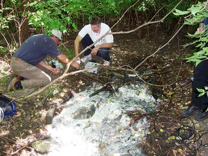
Figure 4. Rick Rice and Keith Hackley are collecting spring water samples at an unnamed saline spring near Quincy, Illinois. The white color of the spring is the result of filimentous bacteria that live near the mouths of hyrogen sulfide rich springs. The color results from the uptake of native sulfur from the spring taken up by the bacteria.
References:
Kolak, J. J., and Burruss, R. C. 2003. An organic geochemical assessment of CO2-Coal interactions during sequestration. U.S. Geological Survey Open-File Report 03-453; U.S. Geological Survey.
Lemieux, J. M. 2011. Review: The potential impact of underground geological storage of carbon dioxide in deep saline aquifers on shallow groundwater resources. Hydrogeology Journal, 19, 757-778.
Nicholas, J. R., M. G. Sherrill, and H. L. Young. 1987. Hydrogeology of the Cambrian-Ordovician Aquifer System at a test well in northeastern Illinois. Water Resources Investigations Open-File Report 84-4165, U.S. Geological Survey, USA.
Visocky, A. P., 1997. Water-level trends and pumpage in the Deep Bedrock Aquifers in the Chicago Region, 1991–1995. Circular 182, Illinois State Water Survey, Champaign, IL, USA.
Zhou, Q., Birkholzer, J. T., Leetaru, H., Mehnert, E., Lin, Y-F., Zhang, K., 2010. Modeling basin- and plume-scale processes of CO2 storage for full-scale deployment, Ground Water, 48(4), 494-514.
Journal Articles on this Report : 1 Displayed | Download in RIS Format
| Other project views: | All 52 publications | 6 publications in selected types | All 5 journal articles |
|---|
| Type | Citation | ||
|---|---|---|---|
|
|
Panno SV, Hackley KC, Locke RA, Krapac IG, Wimmer B, Iranmanesh A, Kelly WR. Formation waters from Cambrian-age strata, Illinois Basin, USA: constraints on their origin and evolution. Geochimica et Cosmochimica Acta 2013;122:184-197. |
R834382 (2011) R834382 (Final) |
Exit Exit Exit |
Supplemental Keywords:
Characterization, Carbon Dioxide, Leakage, Pressure, Monitoring Springs, Mt. Simon Sandstone, Illinois Basin, Multilevel Pressure MonitoringRelevant Websites:
Midwest Geological Sequestration Consortium Exit
The Utility of Multilevel Pressure Measurements in Monitoring Geologically Stored CArbon Dioxide (PDF) Exit (115 pp, 3.74 MB)
Progress and Final Reports:
Original AbstractThe perspectives, information and conclusions conveyed in research project abstracts, progress reports, final reports, journal abstracts and journal publications convey the viewpoints of the principal investigator and may not represent the views and policies of ORD and EPA. Conclusions drawn by the principal investigators have not been reviewed by the Agency.