
Grantee Research Project Results
2011 Progress Report: Impact of Emission Reductions on Exposures and Exposure Distributions: Application of a Geographic Exposure Model
EPA Grant Number: R833624Title: Impact of Emission Reductions on Exposures and Exposure Distributions: Application of a Geographic Exposure Model
Investigators: Marshall, Julian D. , Ramachandran, Gurumurthy
Institution: University of Minnesota School of Public Health
EPA Project Officer: Hahn, Intaek
Project Period: September 1, 2007 through October 31, 2010 (Extended to February 29, 2012)
Project Period Covered by this Report: September 1, 2010 through August 31,2011
Project Amount: $459,556
RFA: Development of Environmental Health Outcome Indicators (2006) RFA Text | Recipients Lists
Research Category: Air Quality and Air Toxics , Air
Objective:
Our research focused on California’s South Coast Air Basin (SoCAB), which surrounds the city of Los Angeles. The SoCAB is an interesting and important case study because of the large population size (16 million people, or about 1 in 19 Americans), generally poor air quality (among the worst ambient concentrations in the United States; on average, the .US. EPA 8-hour ambient ozone standard is violated 1–2 days per week), and an extensive ambient monitoring network (~33 monitors)
We hypothesized that exposure impacts of a given emission reduction strategy vary significantly among (1) source categories, (2) locations within an urban area, and (3) times-of-day. Our objective is to quantify source-to-receptor relationships using existing data and models, so that emission reductions can target sources and locations having the greatest impact on exposures and on environmental justice (EJ). We further aim to use our data to create a policy tool that will quantify exposure and EJ impacts of policy options.
Progress Summary:
Goal 1: Upgrade and improve our existing exposure model
Objective: In previous research, the project PI developed and implemented an approach to estimate population average exposures and exposure distributions (environmental justice) in the SoCAB (Marshall et al., 2006). The model follows the causal source-to-effects chain, starting with emissions, predicting concentrations, and then exposure and intake for a cohort of ~25,000 individuals.
Owing to improvements in computer processor speed and in the cost and availability of computer memory, we were able to make model improvements that were not computationally possible when the model was first implemented. Also, we are now able to make use of a sensitivity analysis approach using “reactive tracers,” which will allow us to study comprehensively the impacts of emission reductions.
Related Project Activities: The exposure model was updated to run with the current version of Visual Studio and code was written for post-processing model output. A major component of this study is evaluating emissions reductions strategies in terms of environmental equity. To this end, a system to quantify various environmental equity metrics and compare model results was developed. Using CAMx with the MATES III study data and the mobility-based exposure model, we determined base-case exposure levels to fine diesel particulate matter and compared results with a one ton per week emissions reduction to the following sources: on-road mobile sources, off-road mobile sources, ships, trains, and stationary sources. We compared intake rates between sources for participants in the travel-activity diary. Additionally, we quantified environmental justice using the Gini coefficient, Atkinson coefficient, and relative difference between high- and low-socioeconomic status groups.
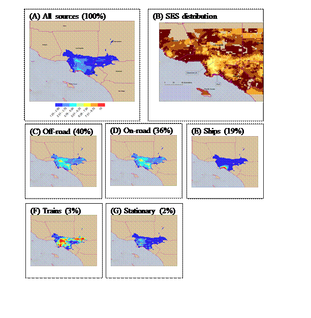
Figure 1: DPM concentrations in the South Coast Air Basin (A) from all sources and (C-G) from each of the five source categories. (B) Socioeconomic Status (SES).
Analyses compare reductions in mean exposure level, versus reductions in environmental injustice. In this case, the optimum solutions would have large reduction for both attributes. Results (see Figures 2 and 4) showed that reductions to train emissions would have the maximum exposure and environmental justice benefit relative to other sources.
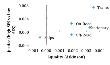 |
Figure 2: Change in the environmental justice (y-axis) and environmental equity (x-axis) metrics observed when emissions are reduced from specific emission sources. Larger x- and y-axis values indicate improvements. Based on these results, for the location modeled, train emissions yield maximal improvements in environmental justice and equity.
Goal 2: Quantify the impact of emission reduction scenarios on exposures and exposure distributions
Objective: We will systematically calculate the exposure impacts of changes to emissions from (1) specific source categories, such as on-road mobile sources, (2) specific locations throughout the air basin, and (3) specific times-of-day. For each emission reduction scenario, we will quantify changes to average exposures and to distributional aspects of population exposures.
Related Project Activities: We conducted sensitivity analyses to determine whether spending the time and computational power to run the mobility model provided more insight beyond using U.S. Census data. We compared various exposure models. The concentrations results were coupled with an exposure model that allowed the calculation of intakes based on the following equation:
Intake (μg/day) = [Concentration] (μg/m3) x [Breathing Rate] (m3/day)
The population in each grid cell was interpolated from the 2000 Census results to calculate the cumulative intake from a given source. In the Results section, this is the Census model.
This model assumes that the population spends their time at home and only breathes the air in the grid cell associated with their residence. Further exposure models incorporate travel-activity diary data that represent the movement and activities of a small subset of people for an actual day. The Base Case of this model uses the population of the travel-activity instead of the Census data and results compared. By further geo-coding locations from the diary and matching them with the CAMx grid cells, we estimate the concentrations a person is exposed to as they travel throughout the day. This is the Mobility model. The travel-activity diary reveals more information about the lives of the study population, including what they are doing and therefore an estimate of their breathing rate can be estimated with more precision than a time-averaged value. Additionally, the concentrations of outdoor pollutants that people breathe change based on where they are, e.g. indoors or in a vehicle. The model that accounts for mobility, breathing rates, and microenvironments is the Mobile + model.
Knowing the total emissions, intake fraction was calculated as follows:

Results for the five sources of DPM for each of the four exposure models are shown below (Figure 3). In general, the mobility-based model sheds light on, for example, time-of-day variability. Based on these comparisons (Figure 3), we concluded that in general, the additional details found in the mobility-based models added unnecessary complexity relative to simpler (Census-based models). We therefore focused our investigation, and our core comparisons, on the Census-based analyses.
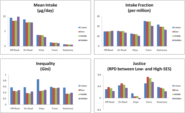
Figure 3: DPM results comparison based on four metrics for the entire domain population (“Census”), the SCAG population sample without accounting for breathing rate variations, mobility, or microenvironments (“Base”), the SCAG population sample including mobility (“Mobile”), and the SCAG population sample accounting for breathing rate variability, mobility, and microenvironments (“Mobile+”) for each of the five diesel sources.
Goal 3: Estimate intake fractions
Objective: For each source category, location, and time-of-day, we will estimate the intake fraction (the fraction of emissions that are inhaled). We will also estimate the intake fraction for specific subpopulations (e.g., the fraction of emissions inhaled by whites versus non-whites).
Related Project Activities: As seen in figure 4, intake fraction was estimated for each of the five source categories using a variety of exposure estimation methods. Based on the direction of the project, the team focused on source and location intake fraction levels and did not calculate intake fractions for the specific subpopulations, since exposures by subpopulation were already calculated.
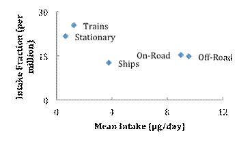 |
Figure 4: Comparison of intake fraction and mean intake, for the five sources.
Intake fraction indicates exposure efficiency. For example, if a policy were to reduce emissions from only one emission source by a fixed quantity (e.g., by 1 ton per year), then the source with the largest intake fraction would yield the largest exposure and health benefit. Based on results here (Figure 4, y-axis), trains have the largest intake fraction. Because they are emitted near to people, they have the largest fraction of emissions being inhaled. In contrast, mean intake (Figure 4, x-axis) is largest for off-road sources, which largely reflects that off-road emissions are the largest emission source. For example, if a policy were to reduce emissions from only one emission source by a fixed percentage (e.g., by 10%), then the source with the largest mean intake would yield the largest exposure and health benefit. Stated differently, train emissions have the largest intake fraction, but their total emissions are small relative to off-road sources.
Specific Goal 4: Decision-making framework
Stated Objective: Our research provides a decision-making framework whereby policy makers can pose “what if” questions, and explore the exposure impacts of proposed policy decisions. If costs for specific emission reductions were available, the model could compare these emission reductions in terms of cost per mass inhaled, rather than in terms of cost per mass emitted. For example, based on modeled diesel PM impacts from ships versus on-road vehicles, one could consider the impact of shifting port activities to a different time-of-day, or of shifting truck traffic to alternative routes (or, to railroad lines). As a second example, considering total and EJ exposure impacts, our model could compare emission controls for neighborhood sources (traffic on surface streets; light industry) versus for trucks (for which most emissions are on freeways).
Related Project Activities: Our research successfully generated a decision-making framework whereby policymakers or other interested parties can choose from among various options to optimize benefits. The examples relevant to the project are examining the tradeoff between intake and efficiency and between environmental equality and environmental justice.
Evaluation of Technical Effectiveness: The methods used are effective at comparing different policy options. The method can be expanded beyond evaluating policy options that target specific sources, such as ships or trains. They can be used to show the effect of location-specific reductions in emissions. The analysis has been shown effective when using generally-available Census data as well as specific and more detailed time-activity diaries, which allow project managers to track the different variables affecting total exposure: breathing rate, exposure point concentrations, and microenvironment. By modeling environmental conditions and comparing that base case to environmental conditions based on hypothetical scenarios, we have an effective decision-making framework that can show the results of policy choices and inform better decisions. We show that there will be tradeoffs between total intake, efficiency, environmental equality, and environmental justice. This framework provides a method to effectively consider multiple impacts of a decision and run multiple scenarios.
Journal Articles on this Report : 3 Displayed | Download in RIS Format
| Other project views: | All 15 publications | 6 publications in selected types | All 6 journal articles |
|---|
| Type | Citation | ||
|---|---|---|---|
|
|
Aggarwal S, Jain R, Marshall JD. Real-time prediction of size-resolved ultrafine particulate matter on freeways. Environmental Science & Technology 2012;46(4):2234-2241. |
R833624 (2010) R833624 (2011) R833624 (Final) |
Exit Exit Exit |
|
|
Marshall JD. Environmental inequality:air pollution exposures in California's South Coast Air Basin. Atmospheric Environment 2008;42(21):5499-5503. |
R833624 (2008) R833624 (2009) R833624 (2011) R833624 (Final) |
Exit Exit Exit |
|
|
Setton E, Marshall JD, Brauer M, Lundquist KR, Hystad P, Keller P, Cloutier-Fisher D. The impact of daily mobility on exposure to traffic-related air pollution and health effect estimates. Journal of Exposure Science & Environmental Epidemiology 2011;21(1):42-48. |
R833624 (2010) R833624 (2011) R833624 (Final) |
Exit Exit |
Supplemental Keywords:
Diesel particles, environmental justice, environmental equality, exposure assessmentProgress and Final Reports:
Original AbstractThe perspectives, information and conclusions conveyed in research project abstracts, progress reports, final reports, journal abstracts and journal publications convey the viewpoints of the principal investigator and may not represent the views and policies of ORD and EPA. Conclusions drawn by the principal investigators have not been reviewed by the Agency.