
Grantee Research Project Results
Final Report: Protection of Critical Source Areas for Achieving Long-term Sustainability of Water Resources
EPA Grant Number: R833363Title: Protection of Critical Source Areas for Achieving Long-term Sustainability of Water Resources
Investigators: Qiu, Zeyuan , Hall, Christine , Messinger, Grace , Abs, Dan Van
Institution: New Jersey Institute of Technology , Natural Resources Conservation Service , North Jersey Resource Conservation and Development Council , New Jersey Water Supply Authority
EPA Project Officer: Packard, Benjamin H
Project Period: May 31, 2007 through January 31, 2009 (Extended to December 31, 2010)
Project Amount: $199,871
RFA: Collaborative Science And Technology Network For Sustainability (2006) RFA Text | Recipients Lists
Research Category: Pollution Prevention/Sustainable Development , Sustainable and Healthy Communities
Objective:
- Establish and maintain an effective network of scientists and agency personnel for protecting critical source areas (CSAs) in landscape;
- Identify CSAs for protection by applying the variable source area (VSA) hydrology modeling techniques with local land use and natural resource condition data;
- Review the existing municipal land use plans, zoning, land development regulations, ordinances and land preservation programs for their effectiveness in protecting CSAs and to explore new planning and preservation program opportunities to extend and enhance the protection of these areas by municipal governments; and
- Design and implement a set of education and outreach programs that help municipalities adopt the proposed land use plans and ordinances to protect CSAs in their communities.
Summary/Accomplishments (Outputs/Outcomes):
Introduction
Project Tasks
- Establish and maintain an effective network of scientists and agency personnel for protecting CSAs at a municipal level;
- Identify CSAs for protection by applying the variable source area (VSA) hydrology modeling techniques with local land use and natural resource condition data;
- Review the existing municipal land use plan, zoning and ordinances and developing land use plans, ordinances and BMPs that are adoptable by municipalities to protect CSAs in local communities; and
- Design and implement a set of education and outreach programs that help municipalities adopt the proposed land use plans and ordinances to protect CSAs in their communities.
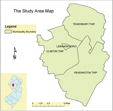
Project Location
The study area includes three municipalities (Tewksbury Township, Clinton Township, and Readington Township) located in Hunterdon County, New Jersey. They have been experiencing rampant land use chances dominated by low density residential development in the past three decades. They also represent different land use development patterns with Clinton and Tewksbury as the most and least developed township among the three. The study area contains some of the most pristine streams called Category One (C1) streams that are subject to the most stringent water resource regulations based on the New Jersey Surface Water Quality Standards. Tewksbury and the north part of Clinton are also in the New Jersey Highlands Preservation Area and are subject to the intense and stringent land and water resource regulation imposed by the New Jersey Highlands Water Protection and Planning Act.
VSA Hydrology, Topographic Index and Critical Source Areas
The VSA hydrology applies a saturation-excess hydrological process to explain how runoff is generated primarily from discrete saturated areas in the landscape. VSAs are these saturated areas that actively contribute to generating runoff. The term VSA implies the extent of saturated runoff source areas varies with soil moisture state. Given certain natural resource conditions in an area, VSAs would develop and expand and shrink in a similar pattern for each storm event. The topographic index is used to derive VSA patterns in landscape that simulates the pattern of surface runoff contributing areas following the VSA hydrology.
Since VSAs are the portions of a landscape that actively contribute to generating runoff, the parts of VSAs that most actively contribute to runoff generation are defined as hydrologically sensitive areas (HSAs). CSAs are determined as the intersection of the HSAs and a set of pollutant source areas in landscapes. The pollutant source areas generally refer to the areas in landscapes that have been actively generating pollutants because of intensive land use activities such as agricultural and silvicultural production, residential development, and industrial and commercial uses.
Community Engagement Planning Process
An interactive three-tier Community Engagement Planning Process is adopted to engage municipalities and their associated regulatory and professional supporting communities through sharing project results, conducting small interest group meetings, roundtable discussions and presentations and providing feedbacks and follow-up to:
- Educate municipal officials and Professional Planners on science behind Critical Source Area model
- Integrate scientific model results and mapping outputs for each municipality based on their water resource planning framework
- Obtain feedback on reality of incorporating modeling results into township planning documents
- Gain acceptance of the recommended land use plans, ordinances, and BMPs that protect CSAs in the targeted municipalities and beyond

Municipal Review and Land Use Controls
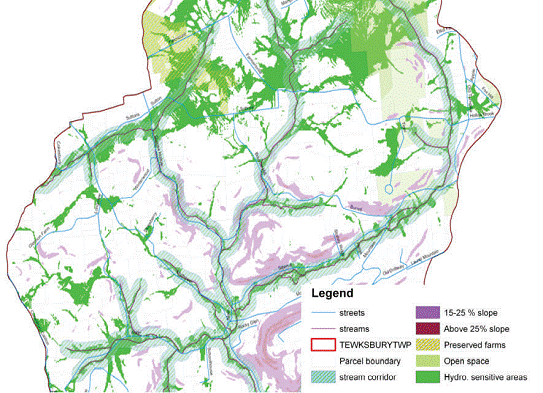
Various land use control measures such as municipal land use plan, ordinances and regulations as well as federal and state programs on smart growth, water pollution, stormwater management, open space and farmland preservation are implemented at a municipal level to direct local land use decisions and protect land and water resources. These land use controls were reviewed for each of the three municipalities to determine at what extent the identified HSAs and CSAs are being protected from intensive land uses in the future by those controls and to evaluate the opportunity of protect the HSAs and CSAs. The land use controls being reviewed include:
- Stream corridor protection mandated by New Jersey Department of Environmental Protection (NJDEP) Stormwater Management Rule (NJAC 7:8), NJDEP Flood Hazard Control Act (NJAC 7:13); wetland protection and mitigation, and municipal stream buffer ordinances.
- State, county, municipal and private preserved open space and farmland;
- Municipal steep slope ordinances that restrict certain developments on the areas with steep slope; and
- More stringent requirements on stream corridor protection and steep slope restrictions in the New Jersey Highlands portion of the study area imposed by the New Jersey Highlands Water Protection and Planning Act.
Field Soil Moisture Measurement
Three fields with distinct land use types in Tewksbury Township were selected to measure soil moisture to evaluate the VSA pattern predicted by the topographic index. Three fields include a natural preserved area, a passively managed recreational park and an active farm with intensive cropping activities. A time domain reflectometry (TDR) Soil Moisture Meter was used to sample soil moisture and a Global Positioning System (GPS) to record the precise location of the sampling points. All three fields have been visited two times, once just after a rainfall event and once during a dry time period. The measured soil moisture data were being analyzed to determine whether the topographic index predicted the actual soil moisture patterns spatially and statistically.
Conclusions:
Translating CSA Protection into Local Land Use Plan and Action
The information on HSAs and CSAs is being incorporated into the municipal and regional planning documents that serve as a foundation for future land use regulations and/or ordinances. These planning documents may include:
- master plan
- open space preservation plan
- natural resource inventory
- farmland preservation plan
- stormwater management plan
- water resource management plan
The information on HSAs and CSAs can be used to improve municipal land use ordinances that protect land and water resources. For example, municipal and regional stream buffer ordinances often require a fixed-width riparian buffer of streams being protected from intensive land use activities. The information on HSAs and CSAs could be used to identify where a lessening of the stream buffer through flexibility provisions should or should not be allowed to achieve greater efficiency and effectiveness. A new municipal land use ordinance can be developed to protect HSAs and CSAs from development or site disturbance developing that are similar to protection of stream buffers, wetlands and areas with steep slopes.
The information on HSAs and CSAs can be used to improve site-specific designs for municipal land use BMPs on groundwater recharge, low impact development, stream restoration and stormwater management. Since HSAs and CSAs are more frequently saturated, they are not ideal locations for groundwater recharge. Low impact development techniques should be applied to reduce the potential of disruption to those areas. HSAs and CSAs might often be inappropriate for stormwater facilities such as detention basins and release channels that increase the frequency of soil saturation, unless facility design addresses the potential for soil and pollutant migration. CSAs can be included in stream restoration designs to prevent head cuts, reduce runoff velocities, and sediment movement to the stream. HSAs and CSAs where disturbed and unstable, can serve as mitigation sites under municipal stormwater management rules.
Journal Articles on this Report : 7 Displayed | Download in RIS Format
| Other project views: | All 16 publications | 7 publications in selected types | All 7 journal articles |
|---|
| Type | Citation | ||
|---|---|---|---|
|
|
Qiu Z. Assessing critical source areas in watersheds for conservation buffer planning and riparian restoration. Environmental Management 2009;44(5):968-980. |
R833363 (Final) |
Exit |
|
|
Qiu Z, Hall C, Hale K. Evaluation of cost-effectiveness of conservation buffer placement strategies in a river basin. Journal of Soil and Water Conservation 2009;64(5):293-302. |
R833363 (Final) |
Exit |
|
|
Qiu Z. Variable source pollution: turning science into action to manage and protect critical source areas in landscapes. Journal of Soil and Water Conservation 2010;65(6):137A-141A. |
R833363 (Final) |
Exit |
|
|
Qiu Z. Prioritizing agricultural lands for conservation buffer placement using multiple criteria. Journal of the American Water Resources Association 2010;46(5):944-956. |
R833363 (Final) |
Exit |
|
|
Qiu Z, Dosskey MG. Multiple function benefit – Cost comparison of conservation buffer placement strategies. Landscape and Urban Planning 2012;107(2):89-99. |
R833363 (Final) |
Exit |
|
|
Qiu Z, Hall C, Drewes D, Messinger G, Prato T, Hale K, Van Abs D. Hydrologically sensitive areas, land use controls, and protection of healthy watersheds. Journal of Water Resources Planning and Management 2014;140(7):04014011. |
R833363 (Final) |
Exit |
|
|
Qiu Z. Validation of a locally revised topographic index in central New Jersey, USA. Water 2015;7(11):6616-6633. |
R833363 (Final) |
Exit Exit |
Supplemental Keywords:
Critical source areas, hydrologically sensitive areas, topographic index, land use control, watershed protection, Sustainable Industry/Business, RFA, Scientific Discipline, POLLUTION PREVENTION, Technology for Sustainable Environment, Sustainable Environment, Ecology and Ecosystems, Energy, economic input output, environmental education, community based, alternative infrastructure design, ecological design, environmental sustainability, green design, sustainable urban environment, land use, energy efficiencyProgress and Final Reports:
Original AbstractThe perspectives, information and conclusions conveyed in research project abstracts, progress reports, final reports, journal abstracts and journal publications convey the viewpoints of the principal investigator and may not represent the views and policies of ORD and EPA. Conclusions drawn by the principal investigators have not been reviewed by the Agency.