
Grantee Research Project Results
Final Report: Evaluating the Timeline of Particulate Matter Exposure from UrbanTransportation and Land-Use Greenhouse Gas Mitigation Strategies Using aNovel Modeling Framework
EPA Grant Number: R835885Title: Evaluating the Timeline of Particulate Matter Exposure from UrbanTransportation and Land-Use Greenhouse Gas Mitigation Strategies Using aNovel Modeling Framework
Investigators: Rowangould, Gregory
Institution: University of Vermont
EPA Project Officer: Keating, Terry
Project Period: January 1, 2016 through December 31, 2018 (Extended to December 31, 2021)
Project Amount: $335,605
RFA: Particulate Matter and Related Pollutants in a Changing World (2014) RFA Text | Recipients Lists
Research Category: Early Career Awards , Air , Climate Change
Objective:
This research aims to create a more robust and detailed understanding of how changes in land-use patterns and transportation systems affect greenhouse gas (GHG) emissions and exposure to fine particulate matter from vehicle traffic along roadways. This is achieved by creating and then applying two novel integrated travel demand, land-use, vehicle emission and exposure modeling frameworks to evaluate how projected changes in travel behavior, transportation infrastructure, vehicle fleets and land-use combine to affect emission rates and population exposure. The research approach is novel in its detailed treatment of time and spatial detail, which our results find have important implications for transportation planning, air quality assessment practice and future research.
Our research focuses specifically on directly emitted (or primary) fine particulate matter and GHG emissions from vehicle traffic. In this research, fine particulate matter is defined as particles having a diameter less than or equal to 2.5 µm (PM2.5). Directly emitted PM2.5 is created from vehicle exhaust (combustion), tire wear, brake wear, and re-suspended roadway dust. Emissions of volatile organic compounds and nitrous oxides from vehicle traffic also contribute to secondary particle pollution.
Directly emitted particle pollution forms elevated concentration gradients along roadways resulting in a heterogeneous concentration surface while secondary particle pollution forms over time as primary air pollutants mix into the regional atmosphere and react with other chemical species and sunlight creating a more homogenous concentration profile. A large body of research finds that exposure to directly emitted PM2.5 emissions from vehicle exhaust is associated with a wide range of adverse health outcomes including heart disease, respiratory illness, and cancer. Studies using roadway proximity or traffic density exposure surrogates also find similar negative health outcomes. The development of PM2.5 microenvironments along roadways and how they shift overtime and interact with people who may become exposed presents significant challenges to air quality and health impact analysis that we seek to address. We do not consider secondary PM2.5 or non-traffic related sources in this research, a boundary that allows us to focus on the particular challenges posed by directly emitted PM2.5 from vehicle traffic.
The modeling frameworks we create use regional travel demand and land-use models that have been implemented by the Mid-Region Council of Governments (Albuquerque, New Mexico) and the Atlanta Regional Commission (Atlanta, Georgia) to evaluate long range transportation plans in each region. We choose Albuquerque and Atlanta as our study sites because their approaches to modeling represent two different advances in regional travel demand modeling that provide unique data and capabilities that we leverage to advance the understanding of how changes to transportation systems and land-use affect GHG emissions and PM2.5 exposure.
The Mid-Region Council of Governments has implemented a trip-based travel demand model with an integrated agent-based land use simulation model. This modeling platform endogenizes land use decisions, making it possible to simulation how changes in transportation infrastructure, vehicle technology, government policies and population growth affect both travel demand and land use decisions. Critically, the Mid-Region Council of Government’s modeling platform enables us to simulate the evolution of vehicle travel and population growth over time and at fine spatial scales.
The Atlanta Regional Commission has implemented an activity-based travel demand model that uses a more traditional exogenous land-use forecast. The strength of this modeling platform is in the spatial and temporal detail of its travel forecasts. The Atlanta Regional Commission’s model simulates routes that each person chooses for each trip they make in a typical day through regions transportation network. The model also simulates where and for how long people spend their time participating in various daily activities such as work, school and being at home. The detailed accounting of travel routes and time spend at different places provides unique data that enables modeling how individuals travel contributes to local PM2.5 emissions and simultaneously how they accumulate PM2.5 exposure as they move about region and spend time in different places. Emission production and exposure can also be tracked on an individual basis allowing for unique exposure equity insights.
We use the integrated modeling frameworks we develop for the Albuquerque and Atlanta regions to evaluate the following four research questions that address our overall research objective:
-
-
- How do changes in regional PM2.5 emission inventories from vehicle traffic relate to changes in PM2.5 exposure?
- How do changes in land-use patterns and the transportation system affect the quantity of GHG emissions and exposure to PM2.5?
- How does the timing of land-use and transportation system changes affect the level of GHG mitigation and PM2.5 exposure?
- How do changes in land-use patterns and the transportation system affect the equity of PM2.5 exposure?
-
Summary/Accomplishments (Outputs/Outcomes):
Conclusions:
Overall, we find that a more detailed accounting of how vehicle emissions evolve over space and time can improve the accuracy of GHG emission inventories and near-roadway PM2.5 emission exposure estimates that are widely used in regional transportation planning, regulatory air quality analysis, and health studies. This finding is based on the results of several experiments and analysis we performed using the two modeling frameworks we developed.
How do changes in regional PM2.5 emission inventories from vehicle traffic relate to changes in PM2.5 exposure?
Air Quality Impacts of Regional Smart Growth Plans
We use the modeling framework that we developed for the Albuquerque region to compare how changes in regional inventories of PM2.5 emissions from vehicle traffic compare to changes in regional population exposure to those same emissions. We compare emissions from baseline travel conditions (year 2012) with a 2040 trend scenario and a 2040 scenario that implements a regional plan designed to reduce GHG emissions by encouraging more compact development. We find that in each scenario average PM2.5 exposure is an order of magnitude higher than the average PM2.5 concentration. This finding indicates that a change in PM2.5 emission inventories may be a weak surrogate for changes in exposure levels. Furthermore, we find that the compact growth scenario results in a somewhat lower PM2.5 inventory than the trend scenario and a slightly higher level of PM2.5 exposure. While the compact growth scenario effectively reduces vehicle travel and overall emissions, vehicle traffic and population become more concentrated resulting in a net increase in exposure. The differences between the two scenarios we modeled were quite small and both show a large improvement in air quality over current conditions. The results highlight the importance of conducing spatially detailed air quality analysis of transportation plans rather than relying solely on regional vehicle emission inventories or other highly aggregate analysis.
Evaluating Changes in PM2.5 Exposure and Health Outcomes in Regional Transportation Plans
We use the modeling framework that we developed for the Atlanta region to evaluate how changes in regional inventories of PM2.5 emissions from vehicle traffic compare to changes in regional population exposure to those same emissions. We also use health impact functions from US EPA’s BenMAP tool to estimate the health impacts from PM2.5 emissions exposure. We evaluate the region’s current long- range transportation plan, estimating PM2.5 emissions from a 2010 base year, 2020 intermediate year and 2040 planning horizon year. Similar to our findings in Albuquerque, we find that the average PM2.5 exposure is substantially higher than the average PM2.5 concentration (generally by an order of magnitude). We also find that the region’s long-range plan would reduce PM2.5 emissions by 52% between 2010 and 2020 and that they would then grow by 50% between 2020 and 2040. Changes in exposure follow a similar pattern; however, the magnitude of the changes differ substantially with a 74% reduction in exposure between 2010 and 2020 followed by 7% increase between 2020 and 2040. The decoupling of changes in PM2.5 inventories and exposure levels are caused by shifting vehicle traffic and population growth patterns in the Atlanta region. Growth in suburban and rural areas results in greater PM2.5 emissions but a relatively small increase in exposure due to lower population density. The results provide further evidence that the air quality and health impacts of regional transportation plans can benefit from a more spatially detailed evaluation.
Exposure Misclassification to PM2.5 from Vehicle Traffic
Most air quality analyses of vehicle traffic emissions estimate exposure from the measured or modeled concentration of an air pollutant at a person's home despite most people spending significant amounts of time in other places. We evaluate exposure to PM2.5 from vehicle traffic and the magnitude and cause of exposure misclassification that result when population mobility is not considered. This is accomplished using the integrated modeling framework that we developed for the Atlanta region. The Atlanta model contains detailed information on the travel routes, times and trip purpose of each simulated person in the Atlanta region which allows us to estimate how people accumulate exposure to vehicle traffic emissions throughout the day as they move about the region. We find that PM2.5 exposure estimates increase by 51% when we account for population mobility. Exposure misclassification is much larger in suburban and rural areas where exposure is generally underestimated and near high volume roadways and in the urban core where exposure is generally overestimated. Exposure that occurs while at work and traveling account for much of the error. We find much larger errors than prior studies that have focused on more compact urban regions. These findings indicate that home-based exposure estimates are unlikely to be a robust estimator of a person's actual exposure. Accounting for population mobility may reveal more effective exposure mitigation strategies, important differences in exposure between population groups with different travel patterns, and reduce exposure misclassification in health studies.
How do changes in land-use patterns and the transportation system affect the quantity of GHG emissions and exposure to PM2.5?
We use the modeling frameworks developed for the Albuquerque and Atlanta regions to evaluate a range of scenarios to understand how changes in transportation systems and land-use affect both GHG emissions and PM2.5 exposure.
Changes Required to Meet Climate Goals
We used the modeling framework that we developed for the Albuquerque region to evaluate the extent to which changes in transportation systems and policy implemented at local and regional governance levels could produce deep GHG emissions reductions. These strategies include increasing the amount of compact and mixed-use development, reducing highway capacity, increasing transit capacity and performance while reducing transit costs, implementing a per-mile tax on driving, and increasing the share of trips made by bicycle. We exclude strategies that aim to increase the energy efficiency of vehicles or increase the use of lower carbon fuels beyond what is expected to occur under current federal policy.
We find that Albuquerque’s current long-range regional transportation plan, which emphasizes more compact development would achieve a small reduction in per capita GHG emissions but an overall net gain once population growth is accounted for. Very aggressive strategies would be required to make deep GHG reductions. The most effective strategies were implementing a very high mileage-based fee ($0.25 per mile with is about $5 per gallon) and directing almost all new growth into existing urban centers or along mass transit corridors. The magnitude of these changes far exceeds what the region has planned for. Even so, these changes would at best only reduce transportation GHG emission by 40% from 2012 levels which is less than what would be required for a proportional contribution to the IPCC’s GHG emission reduction targets of 40–70% over 2010 levels by 2050 to prevent a greater than 2 °Celsius increase in the global mean temperature. The results lead to two conclusions. There is a large gap between regional transportation plans and policies and the GHG mitigation necessary to meet global climate goals and that the rapid advancement of low carbon fuels and electric vehicles will be very important given the challenges of reducing vehicle use.
Impacts of Autonomous Vehicles on Vehicle Travel, Land Use, GHG Emissions and PM2.5 Exposure
We also used the modeling framework that we developed for the Albuquerque region to evaluate how the introduction of Autonomous Vehicles (AVs) could affect the growth in travel demand, land use patterns, and traffic congestion and the implications of these changes on GHG emissions and PM2.5 exposure. Prior research finds that AVs may increase roadway capacity, reduce delay at intersections and decrease the cost of time spent in a vehicle since drivers can engage in activities other than driving. We create several scenarios that consider a fully automated vehicle fleet with each scenario representing a different set of assumptions about how AVs would affect roadway capacity, intersection operation and the value of time spent by people in their vehicles. These scenarios span the range of values found in prior research. We simulate the operation of AVs over a 28-year period using regional population and employment growth forecasts and planned infrastructure development from the region’s adopted long-range transportation plan. We find that in the Albuquerque region, AVs would cause a shift in development towards suburban and urban fringe areas that leads to an overall increase in vehicle travel (9% to 12%) and GHG emissions (1% to 6%). However, AVs would also cause a large reduction in congestion (41% to 101% increase in peak period speeds) which reduces PM2.5 emissions (7% to 21% reduction) and PM2.5 exposure (17% to 33%. reduction). The results indicate that AVs can provide substantial congestion relief and air quality benefits but strategies to control growth in travel demand may be required to prevent an increase in GHG emissions.
How does the timing of land-use and transportation system changes affect the level of GHG mitigation and PM2.5 exposure?
Long range regional transportation plans are typically evaluated with performance measures calculated for the first and final years of 20 to 30 year planning periods. This includes GHG emission inventories and air quality impacts. We call this the endpoint modeling method. Endpoint methods can overlook important changes that occur during interim years as well as cumulative impacts. For example, the impact of GHG emissions accumulating in the atmosphere and chronic or deadly diseases caused by exposure to PM2.5 emissions cannot be reversed by plans that only perform well in the distant future. An alternative approach is modeling incremental changes in transportation infrastructure improvements and population growth and their impacts on travel demand and land use on an annual time scale. We call this the annual approach. The annual approach considers path dependency caused by infrastructure investments and development as well as the relationship between travel demand and land use change. We evaluate a long range transportation planning scenario with a 28-year planning horizon for the Albuquerque region using a typical end-point approach and our annual approach. We find non-linear and sometimes complex changes in annual emission rates, pollution exposure and other performance measures, indicating that end of period performance metrics may not be robust indicators of average and overall plan performance. The implication is that a plan that appears to perform best in the distance future may not have performed as well as others during the interim years. Overall the annual approach results in lower GHG emissions (3.8% less) and PM2.5 exposure (4.2% less) estimates by 2040 when compared to the endpoint approach. Furthermore, we find that the annual modeling method has a large effect on the spatial distribution of land use, traffic and emission concentrations within the region. By 2040, the annual modeling method forecasts greater population and employment, and correspondingly greater traffic congestion and air pollutant concentrations in the region’s largest activity centers than the endpoint modeling method. The findings indicate that the commonly used endpoint travel demand modeling approach may produce inaccurate traffic and population allocation estimates. These inaccuracies then carry forward into GHG emission inventories and PM2.5 exposure estimates.
Furthermore, the annual approach allows for evaluating the cumulative and average impacts that occur over a planning period, rather than focusing solely on distant and largely uncertain further end points.
How do changes in land-use patterns and the transportation system affect the equity of PM2.5 exposure?
We evaluate disparities in PM2.5 exposure by race and ethnicity as well as income group for most of the scenarios we modeled in the research described above in both the Albuquerque and Atlanta regions. In each case, we find that communities of color and those with lower incomes are disproportionately exposed to higher PM2.5 emissions from vehicle traffic. We find that the average exposure of Atlanta’s black population is 23% higher than its white population in the 2010 base year scenario and this disparity grows somewhat overtime while the overall exposure levels decrease substantially. Disparities are even greater for other non-while populations. Low income households (up to 200% of the federal poverty level) face even larger disproportionate impacts in Atlanta where exposure is on average 81% greater than in higher income communities, with the relative size of the disparity also growing overtime. Similar results were found in Albuquerque. Communities of color and those with lower incomes had the highest exposure levels, with the largest disparities found between low income and higher income groups. As was the case in Atlanta, disparities persisted overtime while the overall level of exposure declined. These findings confirm those of many prior transportation air quality studies and demonstrate how more spatially refined modeling methods can be used to evaluate disproportionate impacts during the formation of long range regional transportation plans.
We also evaluate exposure equity by considering how rural, suburban and urban households contribute to marginal exposure levels in the Atlanta region. We estimate separately PM2.5 emissions caused by rural, suburban and urban household travel, their concentrations and the population exposed. Overall, suburban households cause the bulk of emissions exposure in all regions because they represent the largest population group. However, when exposure contributions are evaluated on a per capita basis as shown in Figure 1, on average travel by rural households has a disproportionately large impact on the exposure of urban and suburban households. For example, on average, a driver from a rural household is responsible for a larger share of a suburban household’s PM2.5 exposure than the average driver from a suburban household. On average, rural and suburban drivers also disproportionately impact urban households. These results and the accompanying modeling framework can be used to understand how strategies targeting travel or vehicles used in particular geographic regions can impact exposure in other communities.
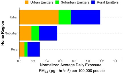
Figure 1. Exposure contributions on a per capita basis.
Journal Articles on this Report : 6 Displayed | Download in RIS Format
| Other project views: | All 16 publications | 6 publications in selected types | All 6 journal articles |
|---|
| Type | Citation | ||
|---|---|---|---|
|
|
Tayarani M, Poorfakhraei A, Nadafianshahamabadi R, Rowangould G. Can regional transportation and land-use planning achieve deep reductions in GHG emissions from vehicles? Transportation Research Part D:Transport and Environment 2018;63:222-235. |
R835885 (2017) R835885 (2018) R835885 (Final) |
Exit Exit Exit |
|
|
Tayarani M, Nadafianshahamabadi R, Poorfakhraei A, Rowangould G. Evaluating the cumulative impacts of a long range regional transportation plan:particulate matter exposure, greenhouse gas emissions, and transportation system performance. Transportation Research Part D:Transport and Environment 2018;63:261-275. |
R835885 (2017) R835885 (2018) R835885 (Final) |
Exit Exit Exit |
|
|
Tayarani M, Poorfakhraei A, Nadafianshahamabadi R and Rowangould GM. Evaluating unintended outcomes of regional smart-growth strategies:Environmental justice and public health concerns. Transportation Research Part D:Transport and Environment 2016; 49:280-290. |
R835885 (Final) |
Exit |
|
|
Poorfakhraei A, Tayarani M and Rowangould G. Evaluating health outcomes from vehicle emissions exposure in the long range regional transportation planning process. Journal of Transport & Health 2017; 6:501-515. |
R835885 (Final) |
Exit |
|
|
Tayarani M and Rowangould G. Estimating exposure to fine particulate matter emissions from vehicle traffic:Exposure misclassification and daily activity patterns in a large, sprawling region. Environ Res 2020; 182:108999. |
R835885 (2019) R835885 (Final) |
Exit Exit |
|
|
Nadafianshahamabadi R, Tayarani M and Rowangould G. A closer look at urban development under the emergence of autonomous vehicles:Traffic, land use and air quality impacts. Journal of Transport Geography 2021; 94. |
R835885 (Final) |
Exit |
Supplemental Keywords:
Climate Change, Exposure Assessment, Environmental Justice, Equity
Relevant Websites:
The PI’s University of Vermont profile Exit
Progress and Final Reports:
Original AbstractThe perspectives, information and conclusions conveyed in research project abstracts, progress reports, final reports, journal abstracts and journal publications convey the viewpoints of the principal investigator and may not represent the views and policies of ORD and EPA. Conclusions drawn by the principal investigators have not been reviewed by the Agency.