
Grantee Research Project Results
2015 Progress Report: Forecasting and Evaluating Vulnerability of Watersheds to Climate Change, Extreme Events, and Algal Blooms
EPA Grant Number: R835203Title: Forecasting and Evaluating Vulnerability of Watersheds to Climate Change, Extreme Events, and Algal Blooms
Investigators: Stevenson, R. Jan , Hyndman, David , Qi, Jiaguo , Moore, Nathan
Institution: Michigan State University
EPA Project Officer: Packard, Benjamin H
Project Period: June 1, 2012 through May 31, 2017
Project Period Covered by this Report: January 11, 2014 through January 10,2015
Project Amount: $749,801
RFA: Extreme Event Impacts on Air Quality and Water Quality with a Changing Global Climate (2011) RFA Text | Recipients Lists
Research Category: Air Quality and Air Toxics , Water Quality , Water , Air , Climate Change
Objective:
Our project is organized in three major tasks with three subtasks under each major task. The first major task was to identify historical algal blooms and statistically investigate how these relate to extreme events across a range of hydrologic regimes. The second major task was to use process-based hydrology and algae models to explore causal linkages between extreme events and algal blooms, and predict the influence of projected climate changes on algal biomass. The third major task was to develop statistical models that can be applied nationwide to examine vulnerabilities to extreme events under different management strategies.
Progress Summary:
Development of a new generation hybridization method (DNA microarrays)
This study (Straub, Battelle Memorial Institute) supported the ground breaking development of a microarray that fingerprints different strains and species of Cryptosporidium. This type of DNA fingerprinting assay permits quick differentiation between genotypes to which humans are susceptible and those which do not infect humans. This technology also lends itself to the detection of other water or airborne disease-causing organisms from natural and intentionally introduced sources. An application of this tool could provide early warning systems for the identification of potential bioterrorism incidents in water supplies.
Development of a new tool to generate long-term whole-lake data of water quality
A machine-learning algorithm developed by an EPA STAR project has improved the accuracy of remote sensing of algal biomass in inland lakes. Satellite data storage and cloud calculation techniques from Google Earth Engine are used to automatically and rapidly produce of long-term whole-lake characterizations of algal biomass using Landsat satellite imagery. Application of this tool improves the accuracy of lake assessment and produces results that can be used for national scale assessments, evaluation of historic conditions in lakes to relate algae to climate and land use change, and forecast vulnerability of lakes to climate change.
Characterizations of algal responses to climate change
Twenty-eight years of lake assessments using satellite imagery with funding from an EPA-STAR project show long-term changes in algal biomass are positively related to increases in lake surface temperatures, even in lakes with high summer temperatures. Annual average algal biomass, the intensity of storm events and water temperature increased over this 28-year period in four Missouri reservoirs, whereas average summer algal biomass did not. Annual average chlorophyll increased by 0.4 μ/L (σ= 0.2) when lake surface temperature increased by 1 °C, but changed little with storm events. These results show that algal biomass throughout the year increases in lakes, even though summer temperatures exceed optimal conditions for algal growth. These results will be valuable for managing lakes with predicted changes in climate and land use change.
Vulnerability of lakes to climate change varies with hydrologic conditions
Remotely sensed whole-lake chlorophyll in 585 lakes in continental United States showed that hydraulic conditions such as basin slope, soil, and land use/cover were more important than lake surface temperature and precipitation in explaining the spatial variation of lake chlorophyll during May-August. That implied algal biomass in lakes were more controlled by internal nutrients that were related to long-term (years) precipitation, other than short-term (months) temperature or precipitation. With climate change, lakes will be at a higher risk of algal blooms mainly due to short-term effect of increasing temperature and long-term effect of increasing intensity of precipitation events. Our studies reveal temperature and precipitation affected algal biomass on different time scales, providing evidence and tools for the assessment of climate change impacts on water quality.
Changing extreme events river flows show coherent regional patterns
Trends in hydrologic extreme events across the Continental United States show coherent regional patterns as a result of EPA-STAR funding. Data from several thousand USGS streamflow gauges were analyzed to quantify how extreme event likelihoods have changed over the last two decades. Particularly striking are dramatic increases in flood extremes across the eastern Great Plains, accompanied by an equally strong decreases in flood extremes across the western Great Plains. Strong, regionally consistent patterns were present across the Corn Belt, Upper Great Lakes, Appalachia, and the Pacific Northwest. (Figure 1)
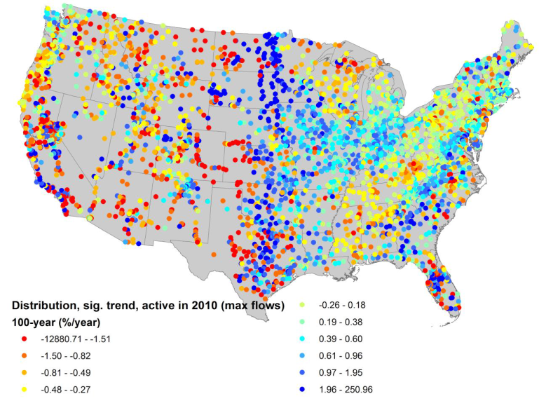
Figure 1. Map of the trend in 100-year event size at all active gauges within the USGS network with at least 20 years of continuous record. Shaded dot values are given in a % change/year.
Part B. Work Status
Our project is organized in three major tasks with three subtasks under each major task. The first major task was to identify historical algal blooms and statistically investigate how these relate to extreme events across a range of hydrologic regimes. The second major task was to use process-based hydrology and algae models to explore causal linkages between extreme events and algal blooms, and predict the influence of projected climate changes on algal biomass. The third major task was to develop statistical models that can be applied nationwide to examine vulnerabilities to extreme events under different management strategies. We asked and received a no cost extension of the project on 4/2/15 that extended the project deadline from 5/31/15 to 5/31/17.
Our project requires using historic satellite images with as much as 50 years of satellite data to characterize algal abundance in lakes. We have been delayed with the remote sensing part of the project, which we had not anticipated being as much of a problem as it has been. Algorithms for estimating lake chlorophyll a with satellite data have not been as useful as we’d expected. The project period extension will allow us to complete the project with the extended funding period.
We reviewed the project Tasks and Subtasks and the corresponding project schedule. We kept the outline of Tasks and Subtasks and fit them to a new schedule (Appendix I).
According to our schedule, we should have started work on Tasks 1 and 2, which need to be substantially completed before we can start Task 3. Progress on Task 1 will be described in this report. No new significant progress has been made on Task 2 compared to the last report.
Task 1
The first two subtasks under Task 1 are:
Task 1a. Characterize historic water quality conditions in Tier 1 lakes.
Task 1b. Characterize historic land uses for Tier 1 watersheds.
We proposed using Landsat imagery from as long as 40 years ago to measure chlorophyll in lakes and characterize historic water quality conditions and land use in watersheds. These data would lay the foundation for relating land use, storm events and algal blooms in subsequent modeling. Due to problems with remote sensing algorithms for measuring chlorophyll a of phytoplankton in lakes using Landsat imagery, we have spent considerable time developing and testing algorithms that can be used a large spatial scales.
Traditionally, most remote sensing models of phytoplankton biomass use linear or polynomial regression and a few band and band ratios that would be expected to sense chlorophyll. In the last report we described our calibration and testing of these models in two settings: one for 447 lakes sampled in the 2007 National Lakes Assessment and the other for the 5 Great Lakes. We found poor cross validation with new data with existing linear and polynomial models. We then applied a new statistical method, boosted regression tree (BRT), which is a machine learning algorithm, to develop models for chlorophyll a using all bands and band ratios in Landsat and MODIS satellite images. The results were greatly improved with better precision of BRT 5 models versus linear and polynomial models in the Great Lakes than the National Lakes Assessment, similar performance of models for chlorophyll and Secchi depth, and better performance for MODIS than Landsat images.
In the last report we described next lines of research. We decided not to follow up with one of those lines, evaluating methods for integrating results of Landsat and MODIS imagery, because MODIS pixels (1 km x 1 km) are too large for most inland lakes that we plan to study. Landsat is important because it has 30 m x 30 m resolution, which is small enough to fit within the deeper contours of small lakes so marginal wetlands and algae on lake bottoms do not affect phytoplankton chlorophyll estimates. We did follow up with the other line of research, in which we tested new Landsat image products that better account for atmospheric interference. We found that these products did not help much with chlorophyll a modeling. Specular reflectance from the water surface from winds seemed to be a major source of error in several lines of our work. So we plan to develop masks for specular reflectance that will enable eliminating pixels when specular reflectance (shimmers from small waves) that infers with seeing water color.
As we progressed with our remote sensing work, we became concerned that non-chlorophyll substances in water also would produce color that could interfere with estimates of chlorophyll and evaluation of storm effects on chlorophyll. Sediment in lakes often accompanies runoff after rains, and sediment produces color in water. Colored dissolved organic matter (CDOM) is produced by in-lake and terrestrial sources, which could interfere with chlorophyll estimates. We found a unique opportunity to study effects of sediment (measured as non-volatile suspended sediments) and CDOM on Landsat measurements of chlorophyll a in a 23-year study of 39 Missouri reservoirs by Jack Jones at the University of Missouri. The dataset was used to calibrate and validate chlorophyll a models using three representative algorithms: multiple linear regression (MLR), general additive models (GAM, non-linear and non-paramedic algorithm), and boosted regression trees using Landsat TM/ETM+ images. BRT and GAM had better performance than MLR. With all algorithms, we found little (< 10%) error related to suspended inorganic sediment and CDOM. We concluded that when using empirical algorithms such as MLR, GAM, and BRT to measure chlorophyll a in turbid waters, variation in NVSS and CDOM conditions should be less of a concern than other sources of error, such as atmospheric correction and specular reflectance. This also leads us to pursue masks for specular reflectance.
During the 2014-2015 project year, we also returned to the U.S. EPA’s National Lakes Assessment to compare different advanced statistical approaches for measuring chlorophyll a with bands and band ratios from Landsat imagery. Models for chlorophyll a based on Landsat imagery were better if they were developed with BRTs than GAMs, MLR, and artificial neural networks. We found that BRTs and GAMs worked better at MLR and artificial neural networks for Landsat measurements of chlorophyll a. Because of ease of use and interpretation, we plan to use BRT models in the future.
Task 1c is to statistically evaluate relationships among hydrology, climate, land uses, and algal biomass. During the 2014-2015 project year, we returned to the U.S. EPA’s National Lakes Assessment for a third time to develop statistical models of phytoplankton sensitivity to three global change variables: temperature, phosphorus, and nitrogen. Preliminary results of this research based on BRT models show strong interactions among temperature, phosphorus concentration, and nitrogen concentration with greatest sensitivity of phytoplankton chlorophyll a to changes in any of these variables when the other two variables are relatively high. Finally, we used the BRT models relating chlorophyll a to temperature and total phosphorus and nitrogen concentrations to predict expected chlorophyll a based on global change. We assumed by assuming a 4°C increase in temperature and 20 and 50% increases in TN and TP, respectively, over the next 50 years in US lakes, as has been predicted in the literature. Based on the BRT model and our global change assumptions, we can expect an average increase of 88% in algal biomass in US lakes in 50 years. We did not find strong evidence that increases in water temperature will increase relative abundance of cyanobacteria in lakes, compared to other types of algae.
There are three subtasks under Task 2:
Task 2a. Refine and test process-based hydrology and algal bloom models in Tier 1 watersheds with different climatic and hydrogeomorphic settings
Task 2b. Statistically downscale projected changes in climate for regional watersheds including Tier 1 lakes
Task 2c. Forecast future algal bloom frequency and algal biomass under projected climate change conditions.
No advances on the Tasks 2 subtasks was made during the last project year.
Task 3 is not scheduled to be implemented at this time.
With respect to delivery of expected results, we have generated remote sensing models for Landsat imagery that predict chlorophyll a and Secchi depth. We have three manuscripts in preparation.
Future Activities:
Focus on the activities of Tasks 2 and 3.
Journal Articles on this Report : 5 Displayed | Download in RIS Format
| Other project views: | All 7 publications | 7 publications in selected types | All 7 journal articles |
|---|
| Type | Citation | ||
|---|---|---|---|
|
|
Haacker EMK, Kendall AD, Hyndman DW. Water level declines in the High Plains Aquifer: predevelopment to resource senescence. Groundwater 2016;54(2):231-242. |
R835203 (2015) |
Exit |
|
|
Luscz EC, Kendall AD, Hyndman DW. High resolution spatially explicit nutrient source models for the Lower Peninsula of Michigan. Journal of Great Lakes Research 2015;41(2):618-629. |
R835203 (2015) |
Exit Exit Exit |
|
|
Luscz EC, Kendall AD, Hyndman DW. A spatially explicit statistical model to quantify nutrient sources, pathways, and delivery at the regional scale. Biogeochemistry<.em> 2017;133(1):37-57. |
R835203 (2015) |
Exit Exit |
|
|
Martin SL, Hayes DB, Kendall AD, Hyndman DW. The land-use legacy effect: towards a mechanistic understanding of time-lagged water quality responses to land use/cover. Science of the Total Environment 2017;579:1794-1803. |
R835203 (2015) R835203 (2016) |
Exit Exit Exit |
|
|
Pei L, Moore N, Zhong S, Kendall AD, Gao Z, Hyndman DW. Effects of irrigation on summer precipitation over the United States. Journal of Climate 2016;29(10):3541-3558. |
R835203 (2015) |
Exit Exit |
Progress and Final Reports:
Original AbstractThe perspectives, information and conclusions conveyed in research project abstracts, progress reports, final reports, journal abstracts and journal publications convey the viewpoints of the principal investigator and may not represent the views and policies of ORD and EPA. Conclusions drawn by the principal investigators have not been reviewed by the Agency.