Vegetation Along the Stream Corridor
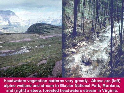
Vegetation is an important and highly variable element in the longitudinal as well as the lateral view. Floodplains are narrow or nonexistent in Zone 1 of the longitudinal profile; thus flood-dependent or tolerant plant communities tend to be limited in distribution, except where wetland plants may dominate at or near the stream's source. Upland plant communities, such as forests on moderate to steep slopes in the eastern or northwestern United States, might come close to bordering the stream and create a canopy that leaves little open sky visible from the channel. In other parts of the country, headwaters in flatter terrain may support plant communities dominated by grasses and broad-leaved herbs, shrubs, or planted vegetation.
Despite the variation in plant community type, many headwaters areas provide organic matter from vegetation along with the sediment they export to Zones 2 and 3 downstream. For example, logs and woody debris from headwaters forests are among the most ecologically important features supporting food chains and instream habitat structure in Pacific Northwest rivers from the mountains to the sea (Maser and Sedell 1994).
Zone 2 has a wider and more complex floodplain and larger channel than Zone 1. Plant communities associated with floodplains at different elevations might vary due to differences in soil type, flooding frequency, and soil moisture. Localized differences in erosion and deposition of sediment add complexity and diversity to the types of plant communities that become established.
The lower gradient, larger stream size, and less steep terrain commonly found in Zone 2 often attract more agricultural or residential development than in the headwaters zone. This phenomenon frequently counteracts the natural tendency to form broad and diverse stream corridor plant communities in the middle and lower reaches. This is especially true when land uses involve clearing the native vegetation and narrowing the vegetated corridor.
Often, a native plant community is replaced by a planted vegetation community such as agricultural crops or residential lawns. In such cases, stream processes involving flooding, erosion/deposition, import or export of organic matter and sediment, stream corridor habitat diversity, and water quality characteristics are usually significantly altered.
The lower gradient, increased sediment deposition, broader floodplains, and greater water volume in Zone 3 all set the stage for plant communities different from those found in either upstream zone. Large floodplain wetlands become prevalent because of the generally flatter terrain. Highly productive and diverse biological communities, such as bottomland hardwoods, establish themselves in the deep, rich alluvial soils of the floodplain. The slower flow in the channel also allows emergent marsh vegetation, rooted floating or free-floating plants, and submerged aquatic beds to thrive.
The changing sequence of plant communities along streams from source to mouth is an important source of biodiversity and resiliency to change. Although many, or perhaps most, of a stream corridor's plant communities might be fragmented, a continuous corridor of native plant communities is desirable. Restoring vegetative connectivity in even a portion of a stream will usually improve conditions and increase its beneficial functions.