Vegetation and Land-Use Patterns
Vegetational patterns
Upland vegetation structure varies spatially, following various biogeographical patterns based on climate, physiography, soils, disturbance regimes, and their interactions.
Vegetation communities are areas where a few species of plants dominate and establish a characteristic form or structure, within which a potentially large number of less abundant organisms also exist. Nationwide, there are hundreds of vegetation community types; the Society of American Foresters recognizes over 80 forest types alone (SAF, 1980). As a first step in analyzing vegetational patterns, it is easier to recognize a few generalized upland vegetation types based on their growth form, including:
- Forests (deciduous, evergreen and mixed)
- Shrublands
- Grasslands
- Forbs (broad-leaved herbs)
These categories are commonly found on land cover maps likely to be available in the GIS data for most watersheds, and can be consulted to give a general sense of vegetation patterns in the watershed.
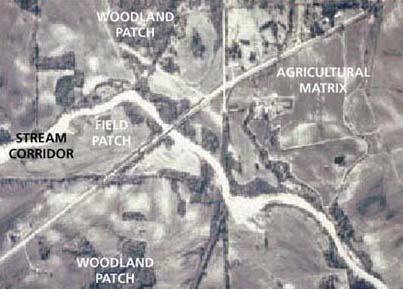
Human activity has carved up and fragmented many of the natural vegetation patterns that formerly covered our watersheds. Without human influence, however, vegetation patterns would not be uniform due to different vegetation communities arising from different environmental conditions (e.g. variations in moisture and temperature due to slope and aspect) and events (e.g., fire, pest outbreak). In the West, the "rain shadow" is a common, basic example of how vegetation varies with physical position. Sierra Nevada example
Land-use patterns
Increasingly, the landscape structure and pattern we see is the result of widespread human activity. In all fields of environmental management including watershed management, analysis of land use types, patterns, and trends is commonplace. Because multiple uses occur in many locations and some land uses are not in themselves a visible landscape feature, mappers often use term land cover to describe the delineation of landscape structure and pattern formed by the dominant land uses and remaining vegetation communities. Some common land cover categories (indicating land uses within the areas) include:
- urban land (residential, commercial, industrial, mixed)
- agriculture (row crops, field crops, pasture)
- transportation (roads, railroads, airports)
- rangelands
- silviculture
- mining/extractive areas
Like vegetation patterns, the land use patterns in a watershed can be studied through GIS data or maps. Human-dominated landscapes, just as natural landscapes, are shifting mosaics that often progress through a series of changes in what is dominant. Rural upstate New York example.