Slope
The slope of the water surface is a major determinant of river channel morphology, and of the related sediment, hydraulic, and biological functions. A longitudinal profile surveyed along a selected channel reach is recommended to be established for slope determinations. When integrated with previous stream classification data, the longitudinal profile survey can also provide slope facet information that can be related to depth and particle sizes for specific bed features. Sediment transport as well as designs for river restoration or fish habitat structures often require such individual slope facet data. With a sufficient array of longitudinal profile data, specific characteristics of riffles, runs, glides, and pools can be compared between each feature and between features of other stream types. It is desirable to describe riffles or pool dimensions in terms of ratios of average slope, depth, and particle size. The existing quality of the surveyed bed features can be related to their response potential by reference reach comparisons.
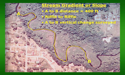
Water surface slope is determined along the longitudinal profile of the channel by measuring the difference in water surface elevation per unit stream length. Slope measurements should be taken through a channel reach that is a minimum of 20 channel widths in length or for a distance equal to two meander wavelengths. The water surface slope should be measured by taking the difference in elevation from the one bed feature to the same bed feature either upstream or downstream. For riffle/pool channels, it is generally best to measure from the top of one riffle to the top of another. It is important to measure the actual stream length rather than estimating the length or running a tape that does not follow the actual channel alignment to avoid overestimating slope. Instruments should be used for elevation change which are appropriate to accurately measure 0.1 feet change in 100 feet distance. The use of clinometers should be discouraged for measuring stream slope, except for very steep streams over 10 percent. On lower gradient reaches, clinometers tend to consistently over-estimate water surface slope. Laser levels are often preferred, as one person can accurately obtain all of the survey data needed for a stream reach inventory. Hand levels with zoom scopes, properly used in conjunction with survey rods, have given sufficiently accurate slope readings.