You are here:
INTEGRATING LAND USE, TRANSPORTATION, AND AIR QUALITY MODELING
Impact/Purpose:
The proposal focuses on one of the key research questions identified in the RFA: “How might models that project changes in land-use and activity locations be improved to better reflect and integrate lifestyle, economic production, and public policy factors that drive vehicle miles traveled?” Our proposal addresses this research topic by building on UrbanSim, an Open Source urban simulation system developed in the last several years at the Center for Urban Simulation and Policy Analysis (CUSPA) at the University of Washington. We propose to integrate into this platform an activity-based travel model component and a network assignment component, and tightly couple this system to air emissions models (Mobile6 and its successor, MOVES).
Description:
The following are highlights of the project, covering the full project period from September 16, 2004 to the completion of the project September 15, 2008:
- Made over 20 presentations at conferences and workshops on research from the research in this project, and prepared and submitted or published over 20 papers in peer-review journals from the research in this project over this period, with several technical working papers completed and in preparation for journal submisson.
- Significantly advanced the behavioral research agenda on the interactions between short-term travel behavior and longer-term household choices related to residence, workplace,a nd auto ownership.
- Significantly advanced the methodological tools and algorithms available to model interdependent choices, addressing a serious endogeneity problem endemic in the research literature in this domain.
- Developed a test-bed application for these advances, with a close partnership with the Puget Sound Regional Council.
- Implemented a parcel-level land use model system in the Puget Sound and integrated it with the currently available travel demand model system.
- Combined the land use and travel model system with the EPA Moves model and ran alternative scenarios from the combined model system.
- Added a cost-benefit analysis component to the model system to support project and scenario evaluation.
- Developed a second test-bed for integrating parcel-level land use modeling with an activity-based travel demand model, in the City of San Francisco, working in partnership with San Francisco County Transportation Authority and the Planning Department of the City and County of San Francisco In the remainder of this section, we summarize the integrated model system and its application within the Puget Sound, concluding with a brief summary of the results of scenario testing. More of these analyses will be done as part of the operational planning by the Puget Sound Regional Council, now that the integrated model system has been brought on-line as their operational model platform. We hope that the results and methods developed in this project will provide a valuable benchmark and foundation for future research to further integrate land use, transportation and emissions modeling and planning.
Integrated Model System Implementation at the Puget Sound Regional Council
The Puget Sound Regional Council (PSRC) has adopted much of the research developed within this project into their operational planning process, which was our hope at the beginning of this project. It demonstrates that the research is not only valuable from a perspective of advancing behavioral research and methods, but also that it is compelling for use in an actual decision-making setting here regional transportation plans and land use are being coordinated with air quality planning in the region. This section describes some of the key aspects of this application, which represents the culmination of several years of effort.
The PSRC has decided to make significant investment in advancing their modeling platforms, in order to be able to address a growing complexity of demands to evaluate alternative policies and outcomes. These include:
New Policies in VISION 2040 (the regional growth management plan)
- Environment
- Economy
- Development Patterns
- Public Services
- Transportation
- Housing
New Solutions in Destination 2030 (the regional transportation plan)
- Demand Management
- Operational Solutions
- Tolling/pricing
- Strategic Capacity Expansion
New Impacts to be Measured (regional indicators)
- Climate Change
- Freight
- Land Use impacts on Transportation
- Reliability
- Health
- Equity
The PSRC has begun a long-term program to create an integrated suite of models that incorporate many of the research findings and methods developed in this project. The first phase of this initiative included applying the UrbanSim model system developed by PI Waddell and collaborators, and calibrating it using local data. In this phase, the model system was connected to the four-step travel demand model system, and to the EPA MOVES model and a Benefit-Cost Analysis Model. How these models inter-relate in terms of the information they provide to the decision-making process is summarized in the figure below:

Figure 1: Integrated Model System and Decision Support at the Puget Sound Regional Council
The integration of the land use and transportation model system with the EPA MOVES model may be the first of its kind. We think that the MOVES model, when fully operational, will be able to perform important functions not available in previous generation emissions models.
Modeling Advancements in MOVES include
- Energy consumption, N2O and CH4 explicitly
- Modal emission rate approach
- Advanced technology vehicles
- Periods of extended idling
- Well-to-pump energy emission estimates to enable life-cycle analysis
Data and Software Improvements include
- Forecasts to the year 2050
- Total energy and emission inventories rather than simply calculating per-mile emission factors
- Second-by-second data to develop emission rates
- Graphical user interface (GUI)
- Relational database to store underlying data
The current application of the integrated model suite is depicted in Figure 2 below.

Figure 2: Application of the Integrated Models for Operational Planning by the PSRC
Finally, some preliminary results from the testing of alternatives scenarios are shown in Figure 3. The scenariois are not described in detail here as they are the subject of ongoing planning and deliberation, and are not finalized. The main point of presenting these preliminary results is to indicate that the application of the research from this project has now reached a state of maturity that it is finding its way into the operational planning processes of Metropolitan Planning Organizations such as the PSRC. Similar efforts are in place at the San Francisco County Transportation Authority.

Figure 3: Comparison of Expected Benefits from Alternative Scenarios by User Type
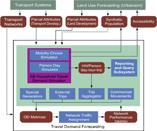
Figure 4: Design for Fully Integrated Activity-based Travel and Land Use Model System
Finally, the roadmap for continuing the development of this integrated modeling platform is now moving to the next stage, motivated by this project, but funded through other sources. It involves developing a fully integrated and operational land use and activity-based travel model system, to address the limitations of the current transportation model, and to incorporate behavioral and methodologicla results from this and related projects. The design for this integrated platform is depicted in Figure 4.
Budget:
Cumulative expenditures on this project between September 16, 2004 and September 15, 2008 totaled $700,000.
Quality Assurance:
Quality assurance in the development of the database used for the calibration of UrbanSim for the Puget Sound region was provided by engaging the staff of the Puget Sound Regional Council, and a Technical Advisory Committee consisting of local planners and other experts. Extensive model validation is underway on the UrbanSim application in the Puget Sound, and this will be used as a baseline for this EPA project.
URLs/Downloads:
2005 Progress ReportFinal Progress Report
2007 Progress Report
2006 Progress Report