
Grantee Research Project Results
Final Report: Harnessing the Hydrologic Disturbance Regime: Sustaining Multiple Benefits in Large River Floodplains in the Pacific Northwest
EPA Grant Number: X3832205Title: Harnessing the Hydrologic Disturbance Regime: Sustaining Multiple Benefits in Large River Floodplains in the Pacific Northwest
Investigators: Gregory, Stanley V. , Hulse, David , Haggerty, Roy
Institution: Oregon State University , University of Oregon
EPA Project Officer: Packard, Benjamin H
Project Period: May 1, 2005 through April 30, 2008
Project Amount: $287,999
RFA: Collaborative Science & Technology Network for Sustainability (2004) RFA Text | Recipients Lists
Research Category: Pollution Prevention/Sustainable Development , Sustainable and Healthy Communities
Objective:
Large river floodplains in the Pacific Northwest are the most ecologically and economically productive lands in the region. We have integrated a study of thermal patterns in the Willamette River (Fig. 1), development of a model of hyporheic influence on water temperature, creation of dynamic visualizations of technical concepts and research results. We have used this information and informatics tools to work with regional decision makers and state agencies to simultaneously derive water temperature reductions, terrestrial and aquatic habitat enhancements, increased recreation and improved non-structural flood storage in large river floodplains while meeting the requirements of the Clean Water Act Total Maximum Daily Load (TMDL) for elevated temperature as a water quality limiting factor and federal Endangered Species Act concerns for elevated stream temperature effects on listed salmonids and other native riverine species. We worked with municipalities, state and federal agencies, and NGOs to find solutions to comply with regulations while maximizing and sustaining the benefits to their constituencies. We developed empirical water temperature data, models of hyporheic exchange, tools for geographic prioritization to an iterative, and interaction with citizens and agencies to find socially plausible solutions. We worked with the Willamette Partnership to provide the technical foundation for developing a market-based thermal credit trading system in the Willamette River mainstem. We also worked with the Oregon Watershed Enhancement Board to use our research findings about thermal refuges to prioritize their Special Investments Program which has dedicated $6 million over the next biennium for restoring the mainstem of the Willamette River. OWEB anticipates that it will dedicate similar levels of funding in future biennia until 2014, when the future of the funding source will be decided by voters.
Our research successfully addressed three fundamental questions:
- What scientific evidence is necessary to understand the mechanisms by which the water temperature reductions occur?
- We developed empirical temperature data from the Willamette River to identify geomorphic and vegetation features of the river and floodplain locations that are related to cold water habitats.
- We installed a network of wells around three typical cold water habitats to provide information required to model the mechanisms responsible for cold water habitats.
- We developed models of three cold water habitats to explore the influence of solar radiation, shade, subsurface temperature, and subsurface flow.
- What riverine features hold the most promise for such temperature reductions?
- Alcoves that extend for the active channel of the river back into the floodplain provided the coldest habitats and some of the largest habitats.
- 37% of the locations sampled in floodplain alcoves met the Oregon temperature standard for a cold water refuge (2˚C colder than mainstem).
- Some floodplain alcoves were as much as 9˚C colder than the mainstem river.
- 15% of the locations sampled in alcoves on gravel bars within the active channel met the Oregon temperature standard for a cold water refuge
- What types of regulator and local citizen mechanisms can increase the likelihood of achieving multiple environmental benefits from efforts to meet regulatory requirements?
- A group of regional experts convened by our research team identified the technical questions that needed to be answered to provide an adequate foundation for regulatory actions related to the temperature standard and cold water refuges.
- Cold water refuges can be restored by restoring dynamic floodplains and channels, removing bank hardening structures (e.g., riprap, dykes, barbs, deflectors, weirs, vanes), maintaining natural flow regimes, and restoring riparian and floodplain vegetation.
- National Pollution Discharge Permits can allow permittees to use floodplain restoration and riparian forest restoration as mechanisms for meeting their thermal load requirements. Permittees can invest in restoration with public and private land owners and managers to meet the requirements of the Clean water Act and provide multiple ecosystem services to the public.
- Thermal credit trading is an emerging tool for addressing temperature TMDLs. Thermal credit trading requires a combination of regulatory requirements (which create the demand for alternative practices and their value) and economic options such as conservation easements, riprap and dyke removal, and riparian vegetation planting (which respond to the need created by regulatory actions).
- The state of Oregon is using the results of the research on cold water refuges to design their restoration program for the Willamette River. The Oregon Watershed Enhancement Board created a Special Investments Program to restore the floodplain, forests, and river channels in the mainstem Willamette River, investing $6 million for each biennium between now and 2014. OWEB asked our research team to provide the spatial framework for prioritizing restoration actions and to serve on their technical advisory committee.
Contacts for Confirmation of Applications of Research Products
Oregon Department of Environmental Quality
DEQ Headquarters:
811 SW 6th Avenue
Portland 97204-1390Neal Mullane
Water Quality Division
Director
neil.mullane@state.or.us
(503) 229-5327
Sonja Biorn-Hansen
Water Quality Division
Environmental Engineer
sonja.biorn-hansen@state.or.us
(503) 229-5257
Oregon Watershed Enhancement Board
Watershed Enhancement Board
775 Summer St NE, Suite 360
Salem, OR 97301-1290
Fax: (503) 986-0199
Web site: www.oweb.state.or.usKen Bierly
Deputy Director
(503) 986-0182
Greg Sieglitz
Monitoring and Reporting Program Manager
(503) 986-0194
Rachel Schwindt
SIP Project Specialist503-986-0185
Oregon Department of Fish & Wildlife
Fish Division
3406 Cherry Ave NE
Salem, OR97303
Fax: (503) 947-6202
Web site: www.oregon.gov/odfwBruce McIntosh
Assistant Conservation & Recovery Program Manager
(541)757-4263 x230
Jeff Ziller
jeffrey.s.ziller@state.or.us
(541) 726-3515 x 26
Kirk Schreoder
kirk.m.schroeder@state.or.us
(541) 757-4263 x 251
U.S. Environmental Protection Agency, Region X
Derek Poon
206-553-4497
Metropolitan wastewater Commission in cooperation with the city of Eugene, Oregon
Peter Ruffier
Peter.J.RUFFIER@ci.eugene.or.us
McKenzie River Trust
Joe Moll
(541) 345-2799
Summary/Accomplishments (Outputs/Outcomes):
Technical aspects of the project
Studies in the Pacific Northwest have indicated that salmonids gather in coldwater microhabitats and may use coldwater habitats as stepping stones to move through reaches that exceed their thermal tolerances (Altman et. al., 1995; Friesen and Ward, 1996; Waite and Carpenter, 1999; Gregory et. al., 2002; Van Sickle et. al., 2004, Lestelle et. al., 2005, McConnaha et. al., 2006). The concerns outlined above regarding elevated water temperature in the streams and rivers of Oregon have led to questions about using floodplain restoration to provide cold water refuges for native biota, particularly where refuges could provide multiple ecosystem and social benefits.
A three-part structure was used in this effort to respond to these questions and concerns.
- First, systematic bottom-of-river water temperature observations were taken in designated locations within the study area between July and October of 2005 and 2006. This period of time is the warm water time of year when native aquatic species are most stressed by elevated water temperatures.
- Second, to map river temperatures for the entire study reach of the mainstem river, we used these observed temperature samples together with a process that predicted expected temperatures in areas not sampled, based on relationships between geomorphic features of the river and the observed water temperatures from the 2005/2006 samples. Using both expected and observed cold water areas and other key biophysical and sociocultural criteria, we then mapped these 2005/2006 cold water areas and compared their spacing to the estimated effective travel distances of both adult cutthroat trout and adult steelhead. This allowed us to identify those locations where distances between cold water refuges exceed effective travel distances of these two fish species. These locations have significant potential for future floodplain restoration where providing cold water refuges for native aquatic species is a primary objective.
- Third, once it was clear where the limits of current knowledge are regarding the effects of water temperature on native fish use of the river, we assembled a group of experts to identify the highest priority scientific questions that need to be answered to move forward with floodplain restoration as a viable strategy for NPDES permit compliance. These questions take the form of a Research Prospectus. As part of this effort we have included in the Prospectus cost estimates for key one-time and recurring data needs.
Summary description of temperature sampling, effective fish travel distance and findings
Salmonid Use of Cold Water Habitat
Research has demonstrated that cold water habitats provide critical refuges for native salmonids, but responses have varied for different locations and species. Chinook salmon in the Yakima River exhibited core body temperatures 2.5˚C lower than the ambient river temperature (Bermann and Quinn 1991). The study concluded that “. . . cool-water areas need to be abundant and available to the fish. The availability of suitable thermal refuges and appropriate holding habitat within mainstem rivers may affect long-term population survival.” In streams of eastern Oregon, several researchers have observed that steelhead trout and Chinook salmon were found primarily in deeper pools or tributary junctions with cooler temperatures (Torgerson et al 2003, Ebersole et al. 2001, Ebersole et al. 2003, Ebersole et al. 2005). Studies in the John Day River system detected little hyporheic exchange, thus cooler temperatures may be source-related and not exchange-related in some streams (Wright et al. 2005). Recent studies of coho salmon in the Smith River demonstrated that coho juveniles avoid warmer mainstem river habitats (up to 25˚C) and aggregated in cold water habitats (Raskauskas 2005). Fifteen cold water refuges identified in 15 km of stream contained the majority of coho salmon. Similarly, Madej et al. (2006) found that coho salmon were restricted to the lower 20 km of Redwood Creek, though historically they occurred throughout the 90-km length of the mainstem. These researchers demonstrated that increased water temperatures in the middle portion of the basin are responsible for the reduced distribution of coho salmon.
Potential Movement Distances of Salmonids in the Mainstem Willamette River
The second major task in developing a spatial framework for cold water refuges in the upper Willamette River was assessment of the potential movement distances of cold water species, such as cutthroat trout and other salmonids. The four major salmonids that occupy the mainstem Willamette River for all or a portion of the year are coastal cutthroat trout (Oncorhynchus clarki), steelhead trout or rainbow trout (O. mykiss), Chinook salmon (O. tschawytscha), and coho salmon (O. kisutch). Only cutthroat trout and Chinook salmon are native to the upper mainstem Willamette River above the Santiam River confluence, and only cutthroat trout occur in the mainstem river in late summer, thus we used cutthroat trout as the reference species for developing an analysis of movement and use of cold water habitats. Data from related salmonids also were used because of the lack of specific movement information for coastal cutthroat trout.
We reviewed more than 50 published studies of salmonid movement in streams of the Pacific Northwest. Most of the literature is based on migratory movements of anadromous salmonids, and likely overestimates the potential travel distances of cutthroat trout in the Willamette River. A study of steelhead in the Rogue River provided one of the most relevant and comparable studies (Everest 1973). Steelhead trout in the Rogue River include large adult steelhead (> 16 inches) and smaller, younger steelhead (12 to 16 inches), which are similar in size to large cutthroat trout in the Willamette River. The smaller steelhead, known as half-pounders, first migrate to the ocean in late winter and return three months later from June to September for their first upstream migration. These half pounders migrate 100 to 160 miles upstream during the spawning migration. Everest (1973) observed that adult steelhead moved an average of 0.9 to 1.1 miles per day and smaller half-pounders moved an average of 0.6 to 0.9 miles per day (increasing from July to September). Warm water temperatures in the Rogue River decreased movement rates, in some cases stopping upstream migration completely (> 69ºF or 20ºC). A study of radio-tagged cutthroat trout in Beaver Creek, Idaho found that diel movement distance ranged from 0 to 259 m per day with a median movement distance of 39 m (Hilderbrand and Kershner 2000). Most fish moved at dawn and dusk.
Several studies have measured seasonal movement distances in tagged fish. While these studies do not provide estimates of daily movement rates, they document the cumulative movement distances over a season. In northern California, coastal cutthroat trout in the Smith River in August moved an average of 100 m upstream and 285 m downstream. Maximum movement distances were 490 m upstream and 1,525 m downstream. Adult Colorado River cutthroat trout (O. clarki pleuriticus) in the North Fork of the Little Snake River in Wyoming exhibited movements of 0 to 2,443 m from June through August with a median movement distance of 332 m (Young 1996). After July 1, movement was reduced and the median movement distance in August was 125 m.
Based on these studies, we conclude that large cutthroat trout (e.g., 30 to 40 cm; 12 to 16 inches) in the Willamette River potentially move less than 1 km per day. Because of warmer temperatures and thermal stress, movement distances are probably lower than this. Overall, potential movement distances of less than 250 m per day are likely for large coastal cutthroat trout, and movement distances of more than 1 km per day are possible but less likely.
Field Measurement of Thermal Patterns
We mapped thermal patterns in the Willamette River between Albany and Eugene from July to October in 2005 and 2006. This provided direct measures of approximately 60% of this geomorphically complex reach of the river. Based on the thermal characteristics of the major channel types, we developed a map of the observed temperatures based on field measurements and projected temperatures based on statistical probability. The combined map provides a spatial framework for cold water habitats in the Willamette River as a basis for designing a linked network of floodplain and river restoration actions to create cold water habitats.
Geomorphic Typology
We mapped the spatial distribution (both longitudinal and lateral) of cold water habitats in the upper Willamette River between Albany and Eugene, Oregon. We used our maps of channel and floodplain complexity in the Willamette River in 1850, 1895, 1932, and 1995 to develop a typology of thermal reach types based on associations of thermal characteristics and channel morphology and floodplain vegetation. We have identified six geomorphic types: 1) mainstem, 2) alcoves on floodplains (Fig. 2), 3) alcoves on gravel bars (Fig. 3), 4) side channels (Fig. 4), 5) gravel bars without alcoves, and 6) embayments. Based on these typologies, we analyzed the observed temperature distributions for 2005 and 2006 and used those statistical distributions to project potential habitat thermal patterns for portions of the river that were not sampled. Based on these projections, we developed spatially explicit representations of the likely thermal patterns of the Willamette River as a basis for estimating reaches of adequate cold water refuges and reaches with no cold water refuges, which may create barriers for the movement and survival of cold water species.
Data Logger Calibration and Deployment
We used three types of temperature data loggers in our field surveys—iButtons, Stowaway, and Optic Stowaway data loggers. iButton Temperature Data loggers (Dallas Semiconductor) are 1.7 x 0.6 cm and record temperature from -5°C to 26°C. Reported measurement accuracy is ±1°C and temperature resolution is 0.125°C. Stowaway TidbiT Temperature Data loggers are 3.0 x 4.1 x 1.7 cm and record temperature from -4°C to 37°C. Reported measurement accuracy is ±0.2°C and temperature resolution is 0.16°C. Optic StowAway Temperature Data loggers are 13.0 x 2.3 x 2.0 cm and have the same measurement specifications as the Stowaway TidbiT data loggers.
We screened all data loggers for accuracy prior to deployment. We rejected data loggers that exceeded ±0.5°C of the temperature measured by a National Institute of Standards and Technology thermometer. Accuracy tests were conducted at 11.5°C and 20.3°C and verified with a National Institute of Standards and Technology thermometer. This calibration process followed the recommended protocol of the Oregon Water Quality Monitoring Guidebook (Stream Temperature Protocols Version 2.0).
Individual iButton data loggers were double sealed inside two small waterproof plastic bags and sealed in galvanized pipe housings (100 mm x 25 mm). Optic StowAway and Stowaway TidbiT data loggers are waterproof and were placed in PVC plastic pipe housings (150 mm x 50 mm). Sealed data loggers were attached to a line and brick anchor so that they rested on the river bottom at each measurement location. Data loggers were deployed either by foot along the shorelines or by boat in deeper sections of the river (>1.0 m). Data loggers were placed on the river bottom at each location (0.25 to 2.35 m depth). Location of each data logger was recorded on maps produced by U.S. Army Corps of Engineers, Portland District (Sheets prepared at 1” = 1000’ from aerial photography flown July, 1999 at a scale of 1:48,000). Each data logger location also was documented with a hand-held GPS unit (Garmin GPS 72).
In summers of 2005 and 2006, we established a longitudinal transect for mainstem river temperature and 10 reach surveys for temperature spatial distribution. Reach survey deployment locations were chosen based on prior field experience of the river and likely cold water areas. Temperature data loggers were placed at intervals of 5 river miles from the confluence of the Willamette and McKenzie Rivers (RM 174.6) downstream to city of Corvallis (RM 130.0). Temperature records were taken at 30 minute intervals from May 15 to Oct. 12 in 2005 and from May 11 to Nov. 7 in 2006. Detailed patterns of water temperature were measured in 10 reach surveys. Approximately 75 to 150 data loggers were distributed throughout reaches that ranged from 2.7 to 12.2 km in length. All lateral habitats (floodplain alcoves, bar alcoves, side channels) were sampled and multiple data loggers were placed in each habitat type. Vertical temperature profiles were determined at representative examples of each of the nine geomorphic river types using a Cole-Palmer Thermistor Thermometer (Model 08402-00) with an YSI 400-Series NIST Traceable Thermister Probe. Temperatures were recorded from the surface to the bottom at 0.25 m intervals.
Figure 5 shows mainstem river water temperatures for two locations (the more northerly, downriver River Mile 130 and the more southerly, upriver River Mile 174.6) between July 15 and October 3, 2005. Note the mainstem river is warmest in early July and that the downriver location (River Mile 130) is consistently warmer than the upriver location (River Mile 174.6). Figure 6 illustrates an example floodplain alcove. It shows water temperatures for Norwood Island Slough and the adjacent mainstem river over a ten day period in August 2005. Note the daily fluctuations and that differing locations within the same alcove can have widely varying temperature profiles.
Development of Cumulative Frequency Distributions for Geomorphic Types
We synthesized thermal data from 853 data loggers deployed in 10 reach surveys in 2005 and 2006. Each individual temperature data logger recorded water temperatures every 30 minutes for 7 to 10 days. We estimated the thermal difference between each location and the mainstem river by subtracting the maximum observed temperature over the 7 to 10-day period for a location from the average maximum mainstem temperature for that study reach. We then ranked all thermal differences for a specific geomorphic type and developed a cumulative frequency distribution for that geomorphic type based on the combined data for 2005 and 2006. Most of the floodplain alcoves were substantially colder than the mainstem river; 39 percent of these habitats were more than 2˚C colder than the mainstem river and 48% were more than 1˚C colder than the mainstem (Fig. 7). Bar alcoves contained cold water refuges but proportionately less than floodplain alcoves; 13% were more than 2˚C colder than the mainstem river and 15% were more than 1˚C colder than the mainstem (Fig. 8). Side channels and embayments exhibited temperatures that were similar to the mainstem river; 1% of side channels were more than 1˚C colder than the mainstem and 4% of embayments were more than 2˚C colder than the mainstem (Fig. 9). Gravel bars without alcoves did not exhibit significant numbers of cold water habitats.
Summary Description of Stepping Stones Analysis and Findings
The stepping stones analysis built on previous peer-reviewed research (Hulse et. al.,
2002, Hulse and Gregory 2004) in which one kilometer floodplain slices were prioritized for
floodplain restoration using human and biophysical factors. Each slice represents a 1 kilometer section of the historical Willamette River floodplain mapped at right angles to the center of the floodplain axis. We used 2005/ 2006 field collected water temperature data to add two additional biophysical factors: 1) percent wetted area 2°C below the mainstem average maximum per slice and 2) number of sites colder than 2°C below the mainstem average maximum per slice. The prioritization was re-calculated using the original social factors and the new set of biophysical factors to create a map with four slice classes: 1) high biophysical potential and low social constraint, 2) high biophysical potential and high social constraint, 3) low biophysical potential and low social constraint and 4) low biophysical potential and low social constraint. Because the field collected temperature data were limited to the area between Corvallis and Eugene, the stepping stones project included only a sub-set of the total Willamette River floodplain slices (Figures 10-13).
We have attempted to develop a prioritization framework for conservation and restoration of cold water refuges and multiple ecological functions of the Willamette River floodplain while considering social and economic characteristics of the floodplain. Conservation focuses on maintaining or conserving existing resources and ecological functions, while restoration focuses on recovery of lost or lacking ecological function and resources. Priorities for future actions can be based on several approaches, which are not necessarily mutually exclusive but could be applied in a sequential or hierarchical process.
The first framework for the “stepping stone” analysis would be an assessment of the potential for restoration of multiple floodplain functions around areas of existing cold water refuges. This approach basically strengthens the existing “stepping stones” for cold water species while restoring additional floodplain functions and resources (Strengthening Stepping Stones Approach). A second framework would be an assessment of the potential for restoring multiple floodplain functions in areas that lack cold water refuges. This approach basically creates new or lost “stepping stones” for cold water species and restores additional floodplain functions and resources to reestablish connectivity along the river (Rebuilding Stepping Stones Approach). A third approach could be more directed at assessing the potential for conservation of existing floodplain functions and cold water refuges. This approach would identify floodplain areas with high ecological condition and the presence of cold water refuges (Floodplain Conservation Approach). In this case, efforts would attempt to maintain areas with high floodplain function and cold water refuges. We then can integrate the biophysical restoration or conservation potential from any of the three approaches with the existing socio-economic characteristics of the floodplain.
For illustration, we have developed an example of the Strengthening Stepping Stones Approach for the reach of the upper Willamette River from Albany to Eugene. We quantified the potential for restoration based on the abundance of thermal refuges in combination with the potential to improve other ecological conditions (based on the observed changes between 1995 and 1850). Restoration potential focuses on the ability to substantial improve the ecological condition of a site. An area of high ecological value may offer little value for restoration if it largely reflects historical conditions and is not likely to substantially increase in the future. It would have high conservation value but low restoration value. From a thermal perspective, substantial ecological restoration could be achieved in an area that contains thermal refuges but has been greatly altered in terms of floodplain and channel complexity, floodplain vegetation and shade, and geomorphic constraint (e.g., riprap, levees, barbs and groins
Based on these principles we have developed an evaluation of the potential for thermal refuge and floodplain function. We assessed the existing thermal refuges and the relative historical changes for each slice in the Willamette River from Albany to Eugene. The biophysical restoration index ranges from 0 to 1 based on the additive and weighted values for:
- Percent of slice wetted area less than 2ºC below the average mainstem maximum temperature (weighting = 30%)
- Number of sites per slice wetted area less than 2ºC below the average mainstem maximum temperature (weighting = 30%)
- Change in length of forest per slice from 1850 to 1990 (weighting = 15%)
- Change in length of channel per slice from 1850 to 1990 (weighting = 15%)
- Length of revetment per slice (weighting = 10%)
The index of social and economic characteristics of the floodplain was based on the following measures for each floodplain slice:
- 1990 population density per slice (weighting = 11%)
- 1990 rural structure density per slice (weighting = 11%)
- 1990 road density per slice (weighting = 22%)
- 1990 area of publicaly owned land per slice (weighting = 22%)
- 1990 area of slice worth more than $2,500 per acre (weighting = 34%)
The indices for potential for biophysical restoration and the indices of socioeconomic constraints were ranked and divided into quadrants. Each index was divided into upper and lower 50 percentiles and illustrated in an x-y plot. The four resulting quadrants represent different categories for prioritization of restoration actions:
- High priority—High restoration potential and low socioeconomic constraints
- Ecologically intermediate priority—High restoration potential but high socioeconomic constraints
- Socially intermediate priority—Low restoration potential but low socioeconomic constraints
- Low priority—Low restoration potential and high socioeconomic constraints
Investments in restoring floodplains and in-river habitats in the high priority sites is likely to provide substantial ecological benefit at lower cost. In the ecologically intermediate priority sites, investments could be coupled with socio-economic incentives and other regional policies to restore floodplain habitats while reducing social obstacles. Investments in the socially intermediate priority sites would not be the highest priorities because of their lower relative increase in ecological value, but they would provide acceptable options when other opportunities are not available. They still provide restoration potential with few social obstacles, and they may be transformed to higher ecological value in the future through river and floodplain dynamics. The low priority sites would face major social obstacles but provide lower ecological value. The ecologically intermediate and low priority sites would be important locations for restoration projects that would serve as demonstration projects for educating the public in areas of high population density.
After assessing alternative approaches for restoration, a biophysically focused framework for cold water refuges could be developed by directly comparing the abundance of coldwater habitats (extstence of “stepping stones”) with the relative change from historical conditions to present ecological conditions (potential for floodplain restoration):
Cold water refuge abundance
- Percent of slice wetted area less than 2ºC below the average mainstem maximum temperature (weighting = 50%)
- Number of sites per slice wetted area less than 2ºC below the average mainstem maximum temperature (weighting = 50%)
- Change in length of forest per slice from 1850 to 1990 (weighting = 40%)
- Change in length of channel per slice from 1850 to 1990 (weighting = 40%)
- Length of revetment per slice (weighting = 20%)
In this example, it is possible to identify high priority areas that lack cold water refuge but have high potential for floodplain restoration. Efforts to restore floodplain functions in these areas have higher potential to create “stepping stones” through restoration efforts and also attain additional ecosystem benefits. In contrast, areas that have existing cold water refuges but do not have high potential to further improve floodplain conditions would not be a high priority because they offer little additional benefit from restoration efforts. Areas with low abundance of cold water refuge but low potential for additional floodplain restoration could be closely inspected to see if slam scale features within the area would still offer the opportunity for creating “stepping stones”.
One final consideration in prioritization is analysis of proximity. After prioritization maps have been developed, an important consideration in restoration priorities is proximity of areas. Restoration of severely degraded sites has been criticized as “rat hole restoration” because the cost of restoration is high and the potential to regain function is low or at least very slow. These critics have suggested that restoring slightly degraded sites or sites immediately adjacent to high quality sites have greater potential for rapid restoration of ecological functions. From this perspective, the floodplain slices adjacent to reaches with abundant cold water refuges, complex channels, and intact floodplain forests would be likely to respond rapidly to restoration and expand the extent of high quality habitats. We suggest that this analysis of proximity would be useful as a second-tier analysis after identifying areas that currently lack cold water habitats but could be restored to restore connectivity along the river.
Temperature Data
Some floodplain kilometer slices in the study area are represented by the 2005/ 2006 field collected temperature data and some are not (Figures 13). For the slices with field collected temperature data, a GIS-based spatial interpolation between points was used to create a mapped representation of temperature. For slices without field collected data, geomorphic river features were identified and matched to temperature distributions from the 2005/ 2006 field collected data (Figure 14).
Percent wetted area 2°C below the mainstem average maximum per slice
For each floodplain kilometer slice, the percent wetted area 2°C below the mainstem average maximum was calculated as the area determined to be 2°C below the mainstem average maximum divided by the total wetted area (Figure 15). The total wetted area was determined from a representation of the active channel circa 2000 as any wetted location with a connection to the mainstem of the Willamette River.
Number of cold sites 2°C below the mainstem average maximum per slice
The number of cold sites per slice was determined using the patches identified as being 2°C below the mainstem average maximum. Each cold patch was located on a map and its point of insertion with the mainstem Willamette River identified the location of a cold site. This means that it is possible for a slice to have a positive percent area that is 2°C below the mainstem average maximum and a zero value for cold site (i.e. its insertion point may be located in an adjacent slice).
Colder water zones’ spatial relationships
Of the 67 floodplain slices analyzed, 31 have non-zero wetted area that is two or more degrees Celsius colder than the mainstem average temperature during the warmest parts of two measurement years. Twenty-seven of the 67 have cold water insertion points, that is, places where cold water from tributaries, side channels, or alcoves flows into the mainstem.
Figure 16 shows that the upriver southerly half of the study area contains more cold water area and shorter average distances between cold water sites than the downriver northerly half. Both of the longest contiguous reaches lacking a cold water slice are downriver of the study area midpoint. By this treatment of the data, no slice in the study area has as much as one fourth of its area colder than the temperature threshold used (2 degrees C colder than the adjacent mainstem average maximum).
Slice colors on Figure 12 depict the four combinations of high and low constraints against ecological restoration, and high and low ecological restoration opportunity. Constraint and Opportunity are indexes each of which are composed of multiple measured physical properties and are expressed via weighted, normalized, and commensurate scales. Slices are colored green if they have both high opportunity and low constraint. Opportunity is defined as low ecological quality now at a location that has high potential for increase in ecological value. Hence, slices that show a higher current fraction of colder wetted area are not necessarily locations at which both restoration potential is high and constraints against restoration are low. This is why some of the slices with larger cold water areas are not colored green in the map.
Due to sinuosity of the river channel, the mainstem travel distance within a slice is typically greater than one kilometer. Thus, fish may often travel more than a kilometer to move from one slice to the next. The one kilometer length of the spatial analytic units is two to four times the estimated distances Cutthroat trout can travel between sites of cold water (Figure 16). Hence the depiction in the attached chart of contiguous cold slices does not demonstrate continuity of cold water.
Based on these results in the area and time period studied, there are three contiguous river reaches (slices 157-164 – 8 kilometers minimum, slices 177-180 – 4 kilometers minimum, and slices 187-193 - 7 kilometers minimum) that lack any observed or expected cold water refuge over a distance far exceeding even the most generous estimate of adult Cutthroat trout and adult Steelhead effective travel distance (Figure 16). Figure 16 focuses on the Green Island portion of the floodplain near the confluence of the McKenzie and Willamette Rivers to illustrate the effect of cold water spacing on effective fish travel distance.
Modeling hyporheic exchange and cold water refuges
We used CE-QUAL-W2 to model the processes that might account for the creation of cold water habitats in alcoves and gravel bars in the Willamette River (Breyenton 2007). CE-QUAL-W2 (Coles and Wells, 2006) is a deterministic, 2D, longitudinal/vertical model that uses the finite difference method to solve the hydrodynamic (conservation of mass and momentum) and water quality (advection dispersion) equations. W2 has been used by the Oregon Department of Environmental Quality to model temperature in their TMDL analysis.
W2 predicts temperature by performing a dynamic energy balance on the stream to account for all sources and sinks of heat, and based on the solutions of the heat transport equation, (Sinokrot and Stefan, 1993; 1994):
(1)
A = cross-sectional area of alcove, m2; cw = specific heat of water, J/(kg˚C); D = dispersion coefficient of alcove, m2/s (Appendix A); Hb = heat flux into or out of alcove bed, W/m2; Hw = heat flux into or out of alcove water surface,W/m2; ql = inflow per unit alcove length - hyporheic water, precip, anthropogenic inputs, m3/(s*m); Q = alcove flux, m3/s; Tw = alcove water temperature, ˚C; Tl = temperature of lateral inputs - hyporheic water, precip., anthropogenic inputs, ˚C; p = wetted perimeter, m; w = width of stream, m; x, t = space & time coordinates, m, s; ρw = density of water, kg/m3. The heat transport equation describes heat transport with advection-dispersion processes. Two variables in equation 1, Hb and Hw, each have separate equations dependent upon temperature and are used in energy budget calculations. Due to its complexity and nonlinearity the heat transport equation is solved numerically by W2.
Heat sources and sinks in each alcove were calculated deterministically, which required substantial data inputs (Figure 17). Data required for performing an energy balance at the alcove water surface were: incoming solar radiation, air temperature, dew point temperature, wind speed and direction, and cloud cover. To calculate the energy balance at the alcove’s water surface the following equation can be used (Coles and Wells, 2006):
(2)
where Hw = heat flux into or out of alcove water surface, W/m2; Hs = incident shortwave solar radiation, W/m2; Ha = incident long wave radiation, W/m2; He = evaporative heat loss, W/m2; Hc = heat conduction, W/m2; Hsr = reflected short wave solar radiation, W/m2; Har = reflected long wave radiation, W/m2; Hbr = back radiation from alcove water surface, W/m2. Hbr, He, and Hc require additional equations to compute and are referenced in the W2 manual (Coles and Wells, 2006; Cox and Bolte, 2007).
The energy balance at the alcove bed is given by the first order approximation, Newton’s law of cooling (Coles and Wells, 2006):
(3)
where Hb = heat flux into or out of alcove at bed surface, W/m2; Ksw = coefficient of sediment/water heat exchange, W/(m2 ⁰C); Tw = water temperature, ⁰C; Ts = sediment temperature, ⁰C.
Dynamic shading accounted for vegetative and topographic shading of the alcove’s water surface, with respect to daily and seasonal location of the sun and foliage.
Alcove Size and Residence Time
The models exhibited temperatures and thermal patterns that were relatively similar to field observations at the three sites (Figure 18). We found that size and hydraulic residence time of an alcove are important factors in determining the main drivers of alcove temperature. A large alcove often has a long hydraulic residence time and behaves more like a lentic system, meaning meteorological conditions drive alcove temperature. Shade, can significantly reduce the solar radiation reaching the alcove and has greater impact on large alcoves. Hydraulic residence time of an alcove determines the effect of shade more than the alcove size. Small alcoves with short hydraulic residence times have temperatures dominated by the temperature and flux of subsurface water emerging into the alcove. Advection dominates the thermal regime of small alcoves.
Alcove Flux
Alcove flux, along with alcove size, determines residence time which strongly influences meteorological impact. Alcove flux is controlled by the hydraulic gradient and hydraulic conductivity of the gravel bar as described by Darcy’s Law (Todd and Davis, 2005).
Increasing either the gradient or the hydraulic conductivity (K) increases discharge of water into the alcove. More subsurface flow, and therefore a higher alcove flux, creates a stable temperature regime by reducing residence time and buffering it from diurnal meteorological conditions (Loheide and Gorelick, 2006; Poole and Berman, 2001). Alcoves became less affected by the meteorological conditions and more by the temperature of the incoming water as alcove flux increased in the model.
Hyporheic Residence TIme
Based on our modeling, we identified three different thermal zones that describe the fluctuations of subsurface temperature (Figure 19). The diurnal zone contains water with residence times less than several days and has fluctuations in temperature dominated by daily changes in air temperature. This type of hyporheic flow typically is limited to 0-2 m below the surface and along short hyporheic flow paths.
The seasonal zone contains water with residence times of months, and has seasonal fluctuations but not diurnal (Silliman and Booth, 1993). The seasonal zone typically occurs 2-10 m below the surface and along intermediate-length hyporheic flow paths. The average temperature in the seasonal zone is approximately equal to the average seasonal temperature of surface water (Malard et al., 2001; Peterson and Sickbert, 2006; Taniguchi, 1993).
The steady-state zone contains water with residence times of months to years, and has very little temperature fluctuation and can be considered constant for the purposes of this study (Anderson, 2005). The steady state zone is found in flows that emerge from 10-20 m below the surface (Taniguchi, 1993) and along long hyporheic or groundwater flow paths. Water temperatures in the steady-state zone are approximately the same temperature as the mean annual air temperature (Domenico and Schwartz, 1990).
The temperature of hyporheic water is determined by the subsurface residence time or “lag time.” The length of lag time determines the temperature at which the hyporheic water will emerge into the alcove. Hyporheic water is moving slower than the mainstem, with subsurface residence times of 0.2 to 30 hours for major flow paths in the main channel on the Willamette River (Fernald et al., 2001). However, lag times can vary between hours and years (particularly for groundwater), and the longer lag times reduce temperature fluctuations due to dispersion (Figure 19) (Stallman, 1965).
Hydraulic residence times are affected by the hydraulic conductivity, size, and hydraulic gradient of the gravel bar. In our field research, thermistors located near the diurnal zone exhibited temperature signals with varying degrees of diurnal and seasonal fluctuation indicating a wide range of lag times .
Lag Time: Hour to Days
Hyporheic flow with a subsurface lag time of hours to days still retains most of its diurnal temperature signal when it emerges into the alcove. At hourly to daily lag times the average temperature of the hyporheic flow emerging into the alcove will not be colder than the average temperature of the mainstem, if there are no other influences on the hyporheic water. Simply, the emerging hyporheic flow is out of phase with the surface water, causing destructive interference with the temperature of the alcove.
Lag Time: Tens of Days to Seasonal
Hyporheic flow with a subsurface lag time of tens of days has no diurnal temperature signal, and is approximately the same average temperature as the mainstem. These lag times are beneficial in regulating the alcove water temperature because of the buffering effect of a constant source of stable water temperature (Poole and Berman, 2001). Hyporheic flow with a subsurface lag time spanning a season will have a different average temperature than that of the mainstem.
Hyporheic flow with a subsurface lag time of years disperses its seasonal temperature signal, thereby moving into equilibrium with the mean annual air temperature. This is the coldest temperature that subsurface water can achieve and therefore the most beneficial to alcove temperature with respect to mitigating maximum daily temperatures in the late summer. We observed cold water upwellings in the Willamette River, indicating lag times of years in come locations. In these locations, subsurface water has reached the same temperature as the groundwater, yet if it originated in the mainstem it is still classified as hyporheic water (Bencala, 2005). However, without performing isotopic analyses it is difficult to distinguish hyporheic water from groundwater at extended time lags.
Implications of field data and modeling for water temperature and floodplain restoration
Exchange between surface and subsurface water can create cold water habitats along streams and rivers, which can serve as important refuges from cold water species. In the face of warming cased by anthropogenic inputs, land use practices, or climate warming, these cold water refuges may be essential for the survival of native aquatic organisms and may limit the impacts of warm water invasive species. Hyporheic exchange is a function of floodplain structure and composition, channel sinuosity, hydraulic gradients, hydraulic conductivity, the heterogeneity of the channel, and bed forms (Boano et al., 2006; Cardenas et al., 2004; Kasahara and Wondzell, 2003). Channel movement during high flows create these important features in streams and rivers, thus maintaining natural flow regimes and dynamic floodplains is essential for protecting and restoring cold water habitats. Floodplain restoration such as removal of bank hardening structures and reconnection of side channels will allow the river to access its new sediment sources, increase habitat heterogeneity, and create new bed forms conducive to high hyporheic flow rates (Fernald et al., 2001; Fernald et al., 2006; Poff et al., 1997; Poole and Berman, 2001).
Social mechanisms for addressing thermal pollution and providing multiple ecosystem benefits
In western Oregon’s Willamette River Basin (Figure 1), efforts are underway to create an ecosystem marketplace exchange (WillamEx) by which people wishing to buy or sell a wide array of ecosystem service credits could conduct transactions (Vickerman 2006). For its initial credit trades, WillamEx is working with water quality regulators and entities that discharge heated effluent into the river from point sources (such as municipal sewage treatment facilities) to fund the removal of river blockages (such as revetments and levees), as well as the retirement of lands in the floodplain, to allow the river to spread onto those lands and flow through gravels below and at the margins of the river—an area referred to as the hyporheic zone. Hyporheic flow, in which river water enters the channel bed and banks to reemerge downstream, promotes biochemical processes that are important for water quality and aquatic habitat. When passing through hyporheic gravels, the water cools considerably and other favorable chemical changes take place. Floodplain restoration through revegetation of riparian areas, creating islands and off-channel habitats, and augmented water flows also provide additional thermal effects and are alternative ways to provide desired ecosystem services in initial trades.
In the past decade ecosystem service provision has emerged as a motivating purpose for environmental management at multiple temporal and spatial extents (Millennium Ecosystem Assessment 2005, Heinz Center 2002, National Research Council 2000). This emergence has come, in part, from a growing awareness of the pervasive effects of human activities on ecosystem processes (Vitousek et al. 1997, Naiman et al. 1995, Meyer and Turner 1994, Gregory et al. 1991).
In exchange for arranging and paying for these non-point sources of temperature “over control,” the point-source entities will receive credits in a trading scheme that will be used to offset their thermal discharges and allow them to comply with temperature wasteload allocations imposed through the Clean Water Act’s total maximum daily load (TMDL) process and incorporated into National Pollution Discharge Elimination System (NPDES) permit conditions (Figure 20). Arguably, the cost to these entities to pay for removal of river blockages, retirement of lands adjacent to the river (through fee title acquisition, conservation easements, or other means), and revegetation activities, will be considerably less than the cost to construct and operate additional on-site temperature control technologies.
In addition to improving the water quality of the river at a reduced cost, this approach to temperature control would have the ancillary benefits of restoring off-channel habitats and creating other conditions favorable to riparian-dependent wildlife while potentially increasing non-structural storage and slowed release of floodwaters, thus reducing downstream risk to flooding. These multiple ancillary benefits are also compelling advantages to the NPDES permit holders and their constituencies.
The U.S. EPA policy authorizing this approach also recognizes that trading schemes have the potential to achieve greater environmental benefits than traditional command-and-control regulatory approaches. Most relevant to this effort is the EPA policy’s encouragement of “the creation of water quality trading credits in ways that achieve ancillary environmental benefits beyond the required reductions in specific pollutant loads, such as the creation and restoration of wetlands, floodplains and wildlife and/or waterfowl habitat”(US EPA 2003). Likewise, the policy encourages water quality trading that “combines ecological services to achieve multiple environmental and economic benefits, such as wetland restoration or the implementation of management practices that improve water quality and habitat.”
WillamEx has several goals: to create financial incentives for voluntary restoration; to make ecosystem benefits bankable, tradable, with market-driven monetary values; to facilitate efficient exchanges with pre-approved credit verification and certification procedures; and to help educate the public about restoration needs and opportunities for beneficial action (Vickerman 2006). WillamEx is a highly innovative departure from conventional command-and-control regulatory approaches to environmental improvement. Much remains to be done in pursuit of these goals, and given the innovative newness of the endeavor, the filling of knowledge gaps about how and where key ecosystem processes operate is a central determinant in its progress.
Identification of technical needs for
A series of three expert meetings were convened in January and February 2007. Attendees were from academic (OSU, UO) and federal research (EPA, USFS) institutions as well as regulatory (ODEQ, ACOE) and regulated (Clean Water Services) agencies. These meetings were held Jan. 29, Feb. 8 and Feb. 13, 2007. What emerged may be considered a prototype approach for addressing any ecosystem service processes where the science is insufficiently understood to allow credit trades to proceed. In such situations, there are five general questions that need to be answered at a satisfying level of scientific detail to allow credit-trading efforts to move ahead:
- How do ecosystem processes that are relevant to credit trading work?
- Where do these processes occur?
- How much of the tradable service exists now?
- How much of the tradable service could be restored and by when?
- What other benefits are likely to result from restoration actions?
Within each of these five general questions, the Research Prospectus lists more detailed questions focused on floodplain restoration’s effects on native aquatic life near the Willamette River mainstem as a viable way to comply with Clean Water Act temperature requirements. It proposes a focus on hydrogeomorphic processes that influence interactions of surface and hyporheic waters and on native fish use of the cold water refuges such interactions create. While the state of science today generally acknowledges that the presence of cold water alone is not sufficient to attract fish to a given river reach, food availability, protection from predators, reduced energy demands to fight river currents are recognized as other important factors. The Research Prospectus acknowledges that little is known about the relative importance each of these factors plays in determining native fish use of these cold water refuges, and seeks to fill this knowledge gap. Finally, it emphasizes actions that people and organizations can take on the ground to benefit aquatic life use through floodplain restoration. It places special emphasis on geographically prioritizing locations best suited for such restoration actions. The full Research Prospectus is attached as Appendix C.
Solutions for environmental problems or is otherwise of benefit to the environment and human health.
Large river floodplains in the Pacific Northwest are the most ecologically and economically productive lands in the region. We have integrated a study of thermal patterns in the Willamette River, development of a model of hyporheic influence on water temperature, creation of dynamic visualizations of technical concepts and research results. We have used this information and informatics tools to work with regional decision makers and state agencies to simultaneously derive water temperature reductions, terrestrial and aquatic habitat enhancements, increased recreation and improved non-structural flood storage in large river floodplains while meeting the requirements of the Clean Water Act Total Maximum Daily Load (TMDL) for elevated temperature as a water quality limiting factor and federal Endangered Species Act concerns for elevated stream temperature effects on listed salmonids and other native riverine species. We have worked with municipalities, state and federal agencies, and NGOs to find solutions to comply with regulations while maximizing and sustaining the benefits to their constituencies. We have developed empirical water temperature data, models of hyporheic exchange, tools for geographic prioritization to an iterative, and interaction with citizens and agencies to find socially plausible solutions. We are working with the Willamette Partnership to provide the technical foundation for developing a market-based thermal credit trading system in the Willamette River mainstem. We also are currently working with the Oregon Watershed Enhancement Board to use our research findings about thermal refuges to prioritize their Special Investments Program which has dedicated $6 million over the next biennium for restoring the mainstem of the Willamette River. OWEB anticipates that it will dedicate similar levels of funding in future biennia until 2014, when the future of the funding source will be decided by voters.

Figure 1. Western Oregon’s Willamette River Basin and the project study area along the floodplain of the Willamette River between the metropolitan areas of Eugene and Corvallis, Oregon.
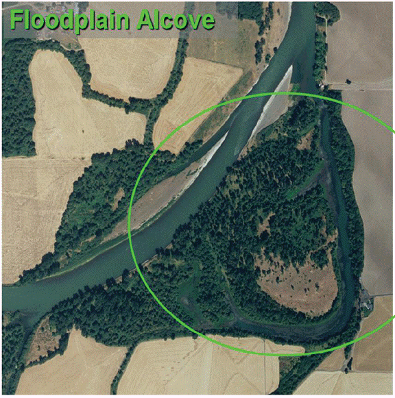
Figure 2. Illustration of an alcove located on a floodplain of the Willamette River.

Figure 3. Illustration of an alcove located on a gravel bar of the Willamette River.
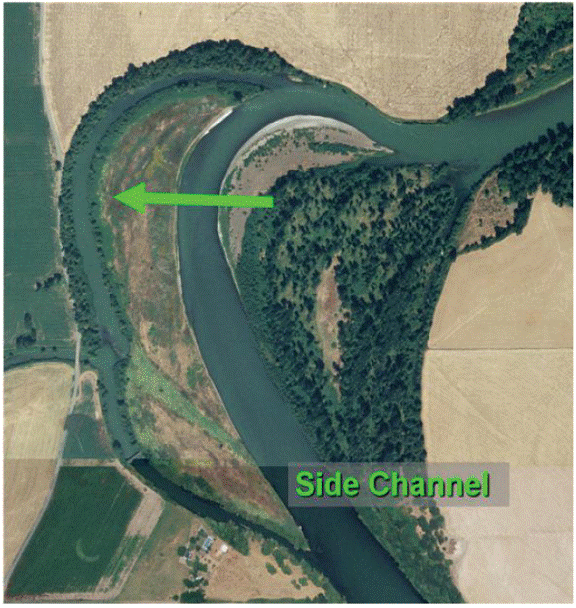
Figure 4. Illustration of a side channel of the Willamette River.
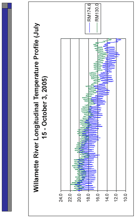
Figure 5. Willamette River temperature profile July 15 – October 3, 2005.
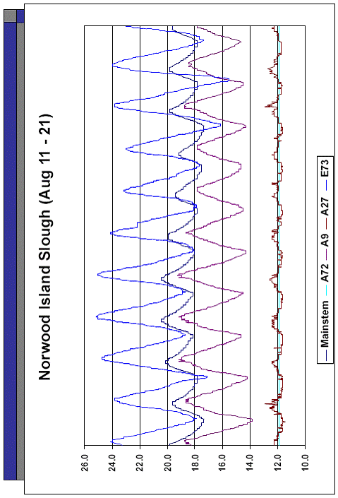
Figure 6. Norwood Island and adjacent mainstem temperatures August 11-21, 2005.
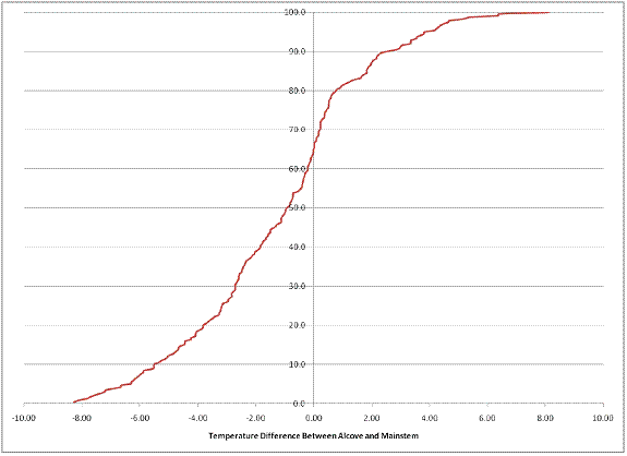
Figure 7. Cumulative frequency distribution of difference between maximum temperature observed in floodplain alcoves and the average maximum temperature for the mainstem section of the same reach.
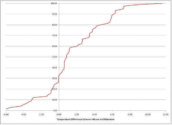
Figure 8. Cumulative frequency distribution of difference between maximum temperature observed in bar alcoves and the average maximum temperature for the mainstem section of the same reach.

Figure 9. Cumulative frequency distribution of difference between maximum temperature observed in side channels and the average maximum temperature for the mainstem section of the same reach.

Figure 10. Map of study area with 1-km slices of historical Willamette River floodplain.
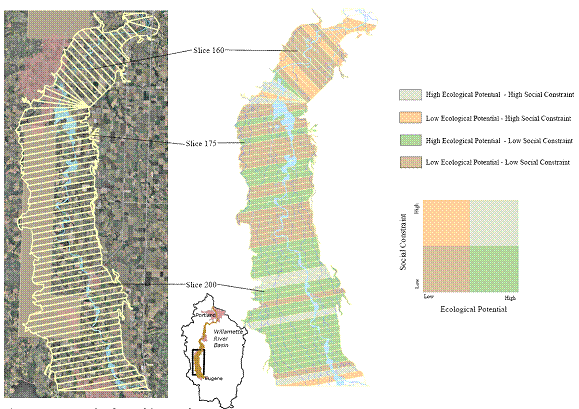
Figure 11. Conceptual and spatial framework of social constraints and ecological potential.

Figure 12. Biophysical and human factors used in prioritizing floodplain slices for cold water stepping stones.

Figure 13. Slices containing observed versus expected temperatures.

Figure 14. Fraction of slice wetted area two or more degrees Celsius below mainstem average maximum temperature.
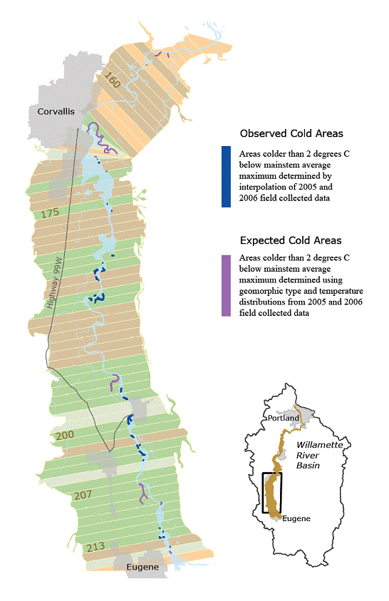
Figure 15. Map of known cold water refuges and projected or expected areas.
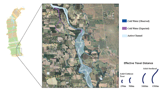
Figure 16. Effective fish travel distance at Green Island.

Figure 17. Green Island site on the Willamette River, RM 171.

Figure 18. Comparison of modeled vs. observed temperature at head of alcove.
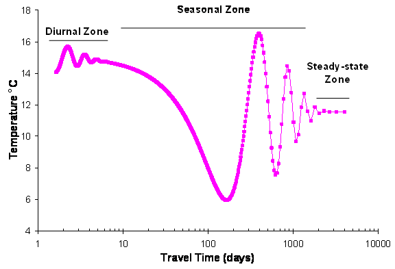
Figure 19. Theoretical temperature dispersion due to lag time of subsurface flow.
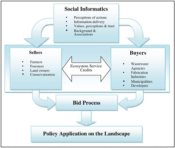
Figure 20. Representation of an Ecosystem Service Marketplace trading process.
References:
Journal Articles:
No journal articles submitted with this report: View all 6 publications for this projectSupplemental Keywords:
River, floodplain, ecosystem, ecosystem services, thermal habitat, thermal refuge, fish communities, land use planning, credit trading,, Sustainable Industry/Business, RFA, Scientific Discipline, TREATMENT/CONTROL, Technology for Sustainable Environment, Water Pollution Control, Sustainable Environment, Urban and Regional Planning, cleaner production/pollution prevention, Environmental Engineering, water conservation, pollution prevention, credit trading, aqueous discharge streams, environmental sustainability, revegetation, collaborative urban planning, water evaluation and urban planning tool, land useProgress and Final Reports:
Original AbstractThe perspectives, information and conclusions conveyed in research project abstracts, progress reports, final reports, journal abstracts and journal publications convey the viewpoints of the principal investigator and may not represent the views and policies of ORD and EPA. Conclusions drawn by the principal investigators have not been reviewed by the Agency.