Classification of High Spatial Resolution, Hyperspectral Remote Sensing Imagery of the Little Miami River Watershed In Southwest Ohio, USA (Final)
EPA announced the availability of the final report,. This report and associated land use/land cover (LULC) coverage is the result of a collaborative effort among an interdisciplinary team of scientists with the U.S. Environmental Protection Agency's (U.S. EPA's) Office of Research and Development in Cincinnati, Ohio.
This work supports the U.S. EPA's watershed (or geographic) approach for protecting designated uses of America's rivers and streams. A primary goal of this project is to enhance the use of geography and spatial analytic tools in risk assessment, and to improve the scientific basis for risk management decisions affecting drinking water and water quality.
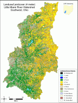
The land use/land cover classification is derived from 82 flight lines of Compact Airborne Spectrographic Imager (CASI) hyperspectral imagery acquired from July 24 through August 9, 2002 via fixed-wing aircraft. Categories within this classification include: water (both lentic and lotic), forest, corn, soybeans, wheat, dry herbaceous vegetation, grass, urban barren, rural barren, and urban/built. These categories may be combined and compared to historical and coarser spatial resolution LULC datasets available for this same geographic area (e.g., the National Land Cover Dataset or NLCD circa 1990s, and the State of Ohio Land Cover 1994).
This work supports the U.S. EPA's watershed (or geographic) approach for protecting designated uses of America's rivers and streams. A primary goal of this project is to enhance the use of geography and spatial analytic tools in risk assessment, and to improve the scientific basis for risk management decisions affecting drinking water and water quality.
The land use/land cover classification is derived from 82 flight lines of Compact Airborne Spectrographic Imager (CASI) hyperspectral imagery acquired from July 24 through August 9, 2002 via fixed-wing aircraft. Categories within this classification include: water (both lentic and lotic), forest, corn, soybeans, wheat, dry herbaceous vegetation, grass, urban barren, rural barren, and urban/built. These categories may be combined and compared to historical and coarser spatial resolution LULC datasets available for this same geographic area (e.g., the National Land Cover Dataset or NLCD circa 1990s, and the State of Ohio Land Cover 1994).
Impact/Purpose
A primary goal of this project is to enhance the use of geography and spatial analytic tools in risk assessment, and to improve the scientific basis for risk management decisions affecting drinking water and water quality. The land use/land cover classification is derived from 82 flight lines of Compact Airborne Spectrographic Imager (CASI) hyperspectral imagery acquired from July 24 through August 9, 2002 via fixed-wing aircraft.
Status
This final document provides technical details about the project, how the LULC product was derived, and metadata compliant with Federal Executive Order 12906. The final products reflect consideration of all comments received from external reviewers dated November 7, 2005.
Citation
TROYER, M. E., J. HEO, AND H. RIPLEY. Classification of High Spatial Resolution, Hyperspectral Remote Sensing Imagery of the Little Miami River Watershed In Southwest Ohio, USA (Final). U.S. Environmental Protection Agency, Washington, DC, EPA/600/R-06/107, 2006.
History/Chronology
| Date | Description |
|---|---|
| Aug 2005 | Internal peer review. |
| Sep 2005 | Internal peer review comments addressed. |
| Oct 2005 | Released for external peer review. |
| Nov 2005 | External peer review comments received. |
| Feb 2006 | External peer review complete and comments addressed. |
| Apr 2006 | Final products cleared and released. |
Additional Information
The resulting LULC product is compatible for import into most Geographic Information Systems (GIS) and includes classification results for the entire Little Miami River Watershed at a spatial resolution of 4m x 4m (KHAT statistic = 0.82). This download product is a Geotiff version of the original smoothed (noise-removal) file described in Troyer, et al. 2006. The Geotiff was converted from the original ERDAS Imagine (.img) file format in ArcGIS 9.0 with the same Albers Conical Equal Area NAD 1983 projection system. Additional metadata for this classification is included in the last section of Troyer, et al. 2006. Please note that a different color scheme was developed for the downloadable Geotiff and includes the following colors and landuse/cover class codes:

This document has been reviewed in accordance with U.S. Environmental Protection Agency policy and approved for publication. Mention of trade names or commercial products does not constitute endorsement or recommendation for use.
- Classification of High Spatial Resolution, Hyperspectral Remote Sensing Imagery of the Little Miami River Watershed in Southwest Ohio, USA (PDF) (66 pp, 2 MB, about PDF)
- LANDUSE/LANDCOVER (LULC) GEOTIFF PRODUCT (ZIP) (49 MB, about ZIP)
- View an image of landuse/land cover product (this is not the downloadable zipped data for analysis)
Related Link(s)
-
1. Daniel, F. Bernard. Influences of Spatial Scale and Soil Permeability on Relationships Between Land Cover and Baseflow Stream Nutrient Concentrations. Environmental Management 45:336–350. 2010.

-
2. Griffith, Michael, et al. Linking Excess Nutrients, Light, and Fine Bedded Sediments to Impacts on Faunal Assemblages in Headwater Agricultural Streams. JAWRA 45(6):1475–1492. 2009.
-
3. Shuster, W.D., et al. Characterizing Storm Hydrograph Rise and Fall Dynamics With Stream Stage Data, JAWRA, 44(6):1431-1440.2008
-
4. Troyer, Michael E. A SPATIAL APPROACH FOR INTEGRATING AND ANALYZING INDICATORS OF ECOLOGICAL AND HUMAN CONDITION. ECOLOGICAL INDICATORS 2: 211-220.
-
LITTLE MIAMI RIVER PARTNERSHIP
- EPA WATERSHEDS WEBSITE
- EPA SURF YOUR WATERSHED WEBSITE - LITTLE MIAMI WATERSHED PROFILE