Low-Density Development
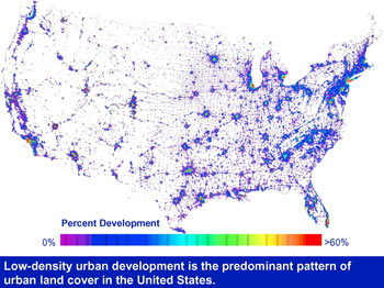
This composite satellite image from space shows that low-density urban development is the predominant pattern of urban land cover in the nation today. The blue areas indicate that low-density urban land cover is much more widespread than the highly urban centers and is closely associated with the national highway network. This diffuse urban expansion is popularly termed sprawl.
Prevailing patterns of development in these areas include separate zoning for residential and commercial uses. Because there are not always other transportation options for everyday activities such as shopping, going to work, entertaining and running errands, this dispersed development pattern results in greater automobile dependency and more vehicle miles traveled.